MyTopo
Nevada GMU 041 South Map
Couldn't load pickup availability
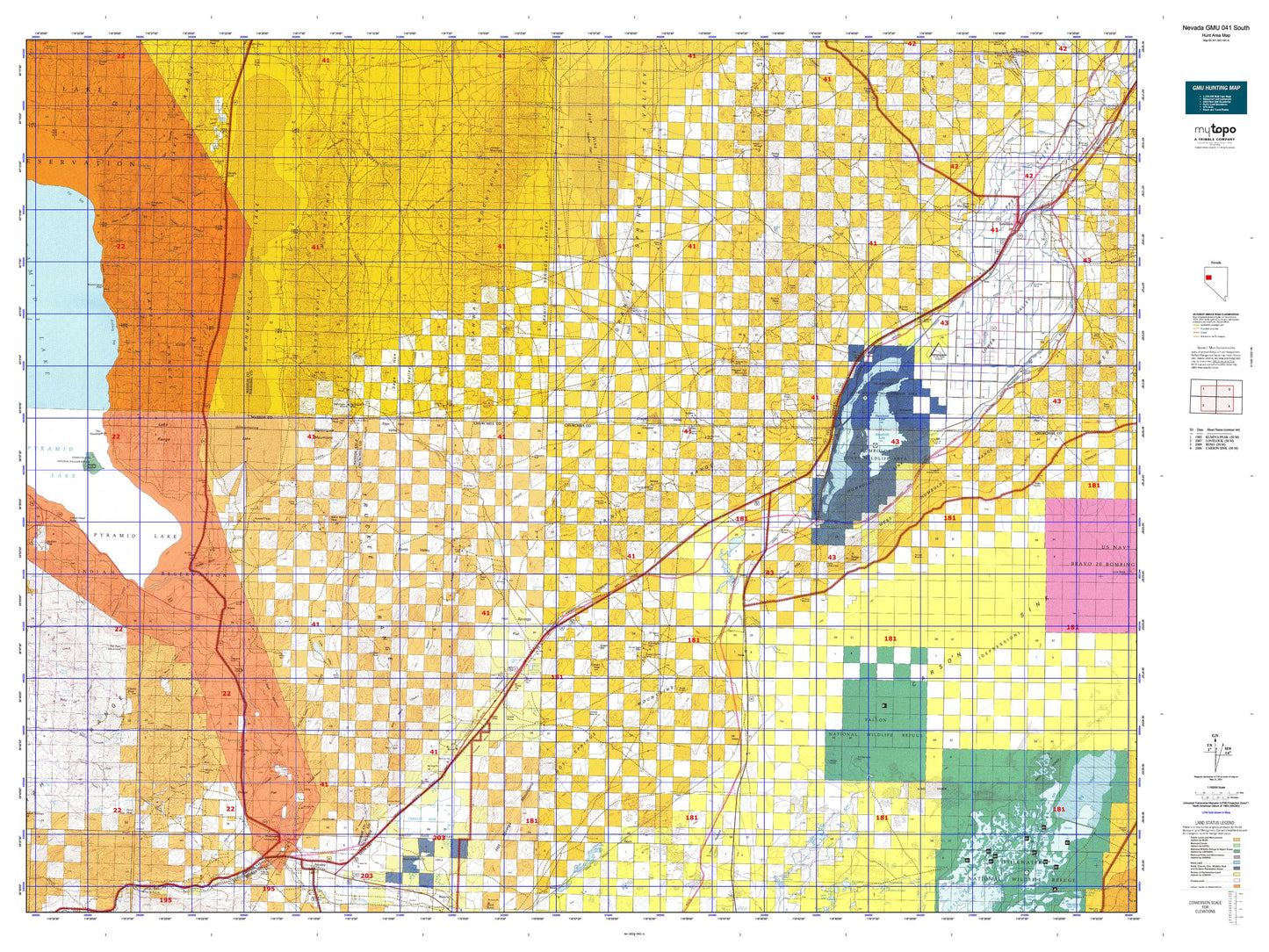
Hunting unit map of Nevada Game Management Unit 041-S with topographic lines and unit boundaries. This topo map features UTM / MGRS and Latitude/Longitude grids, plus public land ownership. It comes folded on waterproof paper. Be fully prepared for your hunt with a MyTopo GMU map!.
This map contains the following named places: 89424,89442,Alexander Mine,Allen Hill,Anaho Island,Anaho Island National Wildlife Refuge,Army Drain,Arobio Ranch,Artillery Bay,Battle Lakes,Battleground Point,Bell Telephone Relay Station,Belle Claims,Big Basin,Big Five Reservoir,Big Meadow Ranch,Big Mouth Creek,Big Slough,Black Mountain,Black Warrior Peak,Blizzard Camp Point,Blue Wing,Blue Wing Cow Camp,Botulism Bay,Bradys Hot Springs,Branch Big Mouth Creek,Browns Station,CAA Station,California Emigrant Trail,Carson River,Carson Sink Division,Central Jessup District Mining Area,Cinnabar Hill,Circle L Ranch,City of Lovelock,Coal Creek,Cooks,Coon Can Mines,Copper Queen Mine,Copper Valley,Cottonwood Ranch,Cressid,Dead Ox Wash,Desert,Desert Mining District,Desert Peak,Desert Quartz Mill,Desert Queen Mine,Desert Siding,Dodge,Dondero Mill,Dove Creek,Duck Lake,Eagle Salt Works,Fairview Slough,Fairview Stage Station,Falais Siding,Fallon Eagle Mine,Fallon National Wildlife Refuge,Fanning,Fernley Sink,Fernley Wildlife Management Area,Fillmore,Fort Defiance Creek,Fox Bay,Fox Beach,Gibson,Gold Butte Mining District,Gold Ore Claims,Granite Point,Granite Springs Valley,Graveyard Drain,Green Hill,Hard to Find Mine,Herstin,Heslip,Hills,Hot Springs Relay Station,Humboldt Lake,Humboldt River,Humboldt Sink,Humboldt State Wildlife Management Area,Huxley,Irish-American Canal,Jackass Peak,James Ranch,Jessup,Johnson Drain,Jones Canyon Ranch,Jones Creek,Juniper Mountain,Juniper Peak,Juniper Range Mining District,K2B Canal,Kits Peak,Lake Mining District,Lakeshore Ditch,Lead Bypass Canal,Lead Lake,Lead Lake Canal,Leete,Leete Mining District,Leete Station,Leter Ranch,Leter Reservoir,Libby,Limbo,Little Valley,Lone Mountain,Lovelock,Lovelock Division,Lovelock Drain,Lovelock Indian Colony,Lower Humboldt Drain,Lower Taylor Ditch,Lucky Lager Ranch,Marble Bluff Fish Research and Control Station,Massie Slough,McClellans Creek,McLane Peak,Millens Channel,Millens Landing,Millers Creek,Mirage,Miriam,Monte Cristo Ranch,Mopung Hills,Moses Rock,Mud Lake Slough,Mule Train Mine,Mullen Creek,Munk Ranch,Muriel,Murphys Station,Nache Peak,Narrow Landing,Nightingale,Nightingale Mining District,Nixon,North Lead Lake,North Valley,Nugent Hole,Numana,Ocala,Old California Trail,Old California Trail East Road,Old Channel Canal,Olinghouse,Olinghouse Junction,Olinghouse Mill,Olinghouse Mining District,Oneida Mill,Ora,Pah Rah Mountain,Paiute Creek,Pallens Wells,Parran,Peers Landing,Pelican Island,Pershing Mine,Perth,Piute Indian Agency,Pond Peak,Pyramid Lake,Pyramid Lake Division,Pyramid Lake Fishway,Pyramid Lake Paiute Reservation,Quail Canyon Ranch,Ragged Top Mining District,Ragged Top Mountain,Red White and Blue Mountain,Reed Ditch,Reids Camp,Rodero Creek,Rodgers Ditch,Romolo,Russell Peak,Sage,Sage Hen Valley,Sage Hen Wash,Secret Creek,Seventeen Ditch,Slip Mill,Sommers Ditch,South Lead Lake Landing,South Swan Landing,Spanish Springs Peak,Stillwater National Wildlife Refuge,Stillwater Wildlife Management Area,Stone Corral,Sugar Loaf,Superior Mining Claim,Swan Lake,Tamarack Bay,Taylor Canal,The Pyramid,Thomas Ranch,Timber Lake,Tohakum Peak,Topog Peak,Toulon,Toulon Drain,Toulon Lake,Toulon Peak,Toy,Toy Mill,Toy Mining District,Trinity,Trinity Peak,Truckee Mining District,Truckee River,Truckee River Outlet,Tule Lake,Tule Lake Landing,Two Tips,Union Canal,Union Rodgers Canal,Upsal Siding,Velvet,Velvet Mining District,Virginia Peak,Wadsworth,Wadsworth Township,West Fork of Old River,West Marsh,White Canyon,White Hill,White Plains,White Plains Flat Mining District,Wilcox Ranch,Wildcat Peak,Willow Lake,Willow Slough,Winnemucca Lake,Winnemucca National Wildlife Refuge