MyTopo
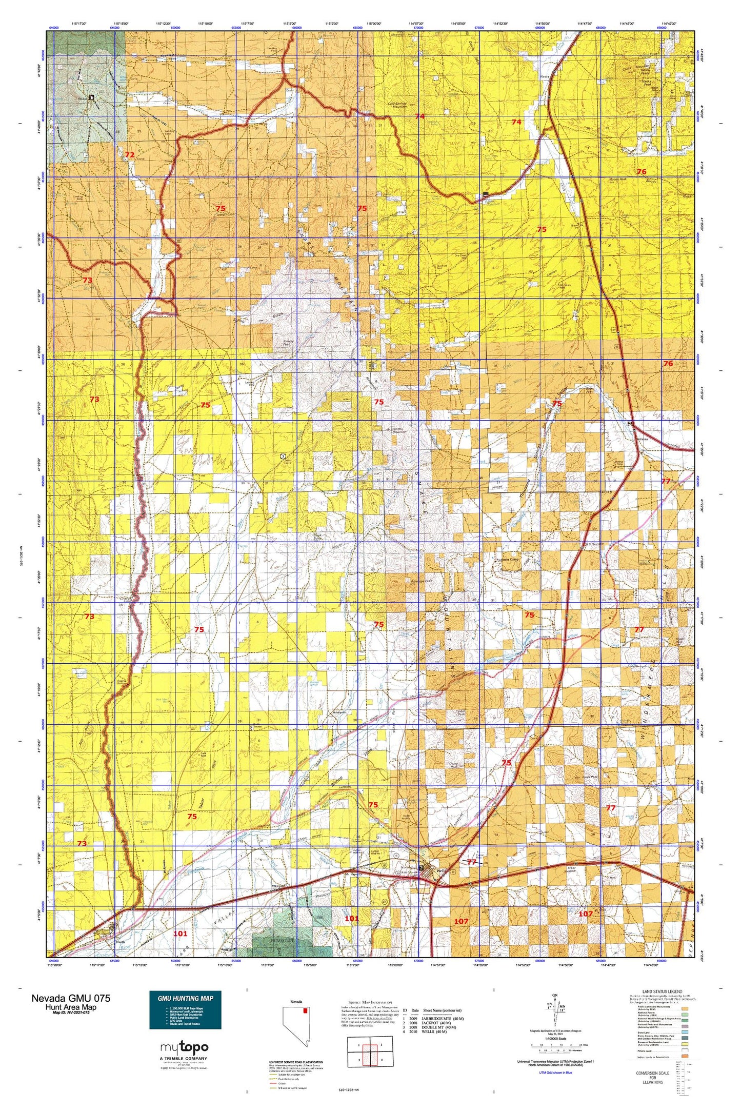
Nevada GMU 075 Map
Couldn't load pickup availability
Hunting unit map of Nevada Game Management Unit 075 with topographic lines and unit boundaries. This topo map features UTM / MGRS and Latitude/Longitude grids, plus public land ownership. It comes folded on waterproof paper. Be fully prepared for your hunt with a MyTopo GMU map!.
This map contains the following named places: Afton,Afton Post Office,Alazon,Allen Creek,Anderson Homestead,Anderson Well,Antelope Peak,Antelope Spring,Antelope Springs,Anthony,Badger Creek,Balsac Basin,Barren Dam,Bathtub Spring,Bishop Creek,Bishop Creek Canyon,Bishop Creek Dam,Bishop Creek Reservoir,Bishop Flat Spring Number Forty,Bishop Flat Well,Bishop Flats,Bishop Spring,Bishops,Black Butte,Boies Reservoir,Brush Creek Well,Buena Vista Ranch,Buffalo Spring,Bull Camp,Bull Camp Creek,Burnt Creek,Camp Creek,Can Creek,CD Ranch,Cedar,Cedar Pass,Cedar Peak,Chalk Spring,Chicken Seep Spring,Chicken Spring,China Mountain,Cold Spring,Cold Springs Creek,Cold Springs Mountain,Corner Reservoir,Corral Spring,Cottonwood Canon,Cottonwood Spring,Cricket Creek,Cricket Spring,Currant Creek,Dahl Well,Dead Bull Creek,Dead Bull Spring,Deer Creek,Dixons Marys River Ranch,Draw Creek,Dry Basin Well,Dry Creek,Dry Creek Ranch,Dry Creek Well,Dry Fork Jakes Creek,Dynamite Spring,Eagle Flat,East Fork Deer Creek,Fawn Basin,Finks Canyon,Forleen Butte,Gibbs Ranch,Gilmer Ranch,Grock Ranch,H D Summit,Hanks Creek,Hanks Creek Dam Site,Harris Canyon,Harris Canyon Dam,Henry,Herrell,Hopkins Ranch,Hot Creek,Hot Creek Springs,Hot Spring,Hot Springs,Hot Springs Creek,Hubbard,Hubbard Basin,Hubbard Ranch,Hubbard Well,Humboldt Wells,Hylton Well Number One,Hylton Well Number Two,Independence Springs,Independence Station,Indian Hollow,Jakes Creek Dam,Johnson Creek,Jude,Knoll Creek,Knudson Ranch,Ledge Spring,Loomis Creek,Loomis Mountain,Loomis Pasture,Lower Bishop Creek,Lower Hubbard Basin,Lower Marys River Dam Site,Mala Vista Ranch,Marys River Cabin,Marys River Ranch Airport,Marys River Well Number 1,Melandco,Metropolis,Metropolis Cemetery,Metropolis Post Office,Metropolis Volunteer Fire Department,Middle Fork Deer Creek,Middle Fork Jakes Creek,Moor,Morlan,Morton,Morton Post Office,Mud Spring,Mud Springs,North Fork Burnt Creek,North Fork Jakes Creek,North Fork Willow Creek,O'Neil Basin,O'Neil Elementary School,Oxley Peak,Pole Creek,Quilici Spring,Rabbit Creek Reservoir,Ralphs Well,Red Point,Red Spring,Rocky Peak,Sagehen Spring,Schoer Place,Shores,Single Tree Ranch,Skinners Point,Snake Mountains,South Fork Currant Creek,South Fork Jakes Creek,South Fork Willow Creek,Spratling Well,Spring Creek,Spring Gulch,Starr,Stormy Canyon,Stormy Creek,Stormy Peak,Summer Camp,Summer Camp Ridge,Summit Springs,Sun Creek,T Creek,Tabor Flats,Threemile Spring,Thurston Ranch,Town Creek,Town Creek Flat,Town Creek Spring,Town Creek Well,Trough Canyon Spring,Trout Creek,Tulasco,Tulasco Section House,Twelvemile Spring,Twin Ledge Spring,Uhlig Ranch,Urresti Ranch,Vineyard Ranch,Weeks Well,Wells City Cemetery,Wells Colony,Wells Peak,West Antelope Spring,West Fork Deer Creek,West Tabor Well,Wild Horse Creek,Wildcat Creek,Wildcat Spring,Wilkins,Wilkins Post Office,Willow Creek,Willow Spring,Willow Springs,Wilson Spring,Winchell Spring,Wood Ranch Well Number Fifty Three,Wrights Well