MyTopo
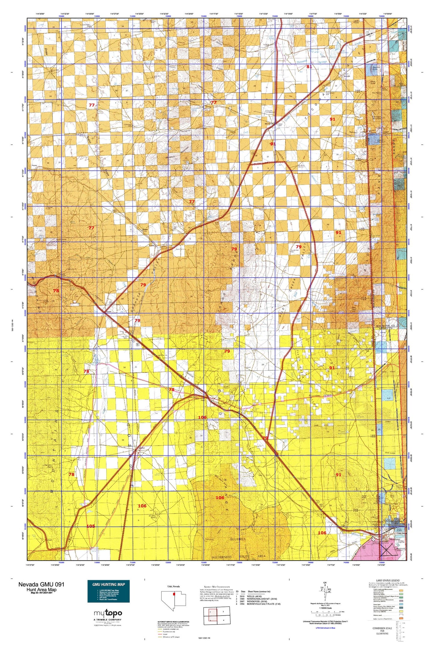
Nevada GMU 091 Map
Couldn't load pickup availability
Hunting unit map of Nevada Game Management Unit 091 with topographic lines and unit boundaries. This topo map features UTM / MGRS and Latitude/Longitude grids, plus public land ownership. It comes folded on waterproof paper. Be fully prepared for your hunt with a MyTopo GMU map!.
This map contains the following named places: 89830,89883,Adele Spring,Akbar,Arnold,Baker Mine,Baker Spring,Bald Eagle Canyon,Bar O Ranch,Bauvard,Bauvard Post Office,Big Springs,Big Springs Ranch,Black Butte,Box Canyon,Boyd Spring,Buckhorn Creek,Buel Post Office,Buell,Castle Park Well,Charley Canyon,Charley Creek,Cliffside Well,Clifside,Cobre,Cobre Post Office,Cobre Well,Cobrecite Mine,Collar and Elbow Basin,Collar and Elbow Dam,Collar and Elbow Spring,Cook Canyon,Cottonwood Springs,Cove Springs,Cummings Ranch,Dake Reservoir,Dake Reservoir Dam,Debbs Canyon,Debbs Creek,East Canyon,East Squaw Creek,Eightyfoot Well,Fat Woman Canyon,Gamble Canyon,Gamble Creek,Gamble Ranch,Gamble Ranch Landing Strip,Gamble Spring,Gamble Well,Gath,Granite Springs,Gravel Pit Spur,Grouse,Hardy Creek,Highway Well Number Seventy-eight,Hogans Alley,Hoppie Basin,Hoppie Basin Spring,Hoppie Basin Well,Hoppie Canyon,Hoppie Creek,Horse Canyon,Icarus,Immigrant Canyon,Immigrant Creek,Iron J Mine,Ives Pass,Jackson Dam,Jackson Siding,Jim Thomas Well,Jog Well,Johnson Well,Juniper Airport,Killian Springs,KYOU-FM (Wendover),Leach Ranch,Leach Range,Leppy Hills,Leppy Peak,Leppy Reservoir,Lewis Spring,Little Salt Spring,Long Canyon,Long Canyon Spring,Loray,Loray Campground,Loray Draw,Loray Mining District,Loray Reservoir,Loray Wash,Lost Hope Mine,Lucin Mining District,Luke,Mahogany Canyon,Mahogany Spring,McCuistion Springs,McDonald Creek,Medicine Creek,Milk House Spring,Miners Canyon,Miners Spring,Montello,Montello Canyon,Montello Census Designated Place,Montello Creek,Montello Division,Montello Elementary School,Montello Landing Strip,Montello Post Office,Montello Springs,Montello Well Number One,Montello Well Number Two,Murdock Mountain,Murdock Springs,Nanny Creek,Nick Del Duke Mine,Noble,Noble Well,North Fork East Squaw Creek,North Fork Squaw Creek,North Pass,North Spring,Oasis,Oasis Census Designated Place,Omar,Parson Springs,Patterson Gulch,Pearson Ranch,Pequop Maintenance Station,Pequop Summit,Pierces Creek,Pilot,Pilot Creek Ranches Airport,Pilot Creek Valley,Pilot Mountain Ranch,Pilot Peak,Pilot Peak Historical Marker,Pilot Peak Mining District,Pilot Range,Pilot Well,Proctor,Proctor Mining District,Quartzite Canyon,Railroad Well,Regulator Canyon,Ridge Well,Salt Spring,Shafter,Shafter Post Office,Shafter Well Number One,Sheep Spring,Silver Hoard Mine,Silver Zone,Silver Zone Basin,Silver Zone Pass,Silver Zone Post Office,Silver Zone Well,Six Shooter Canyon,Sixmile Creek,Small Spring,South Fork East Squaw Creek,South Spring,South Well,South Well Number 3,Spud Canyon,Squaw Creek Ranch,Squaw Flat Well,Stockberger Well,Stockland Reservoir,Summit Spring,Tecoma,Tecoma Post Office,Tecoma Township,Tecoma Township Volunteer Fire Department,The Loop,Tioga,Toano,Toano Number Thirteen Spring,Toano Post Office,Toano Range,Toano Well Number Two,Toilet Well Number One,Toilet Well Number Two,Tunnel Spring,Tuttle,Ullin,Valley Pass,Valley Well,Wally Spring,Warm Springs,West Morris Basin,Willow Canyon,Willow Spring,Window Rock