MyTopo
Nevada GMU 121 South Map
Couldn't load pickup availability
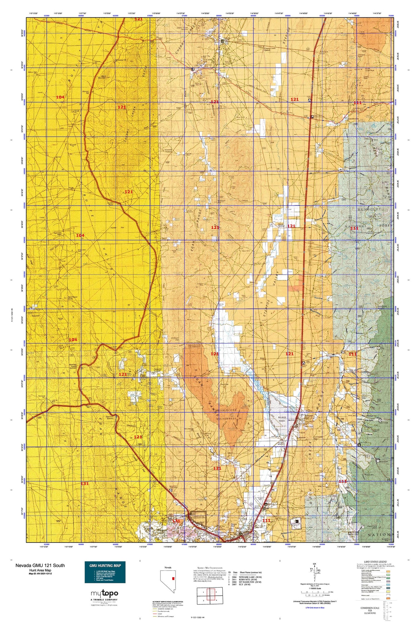
Hunting unit map of Nevada Game Management Unit 121-S with topographic lines and unit boundaries. This topo map features UTM / MGRS and Latitude/Longitude grids, plus public land ownership. It comes folded on waterproof paper. Be fully prepared for your hunt with a MyTopo GMU map!.
This map contains the following named places: 171 Ac Pond-McGill Dam,78 Ac Pond-McGill Dam,89301,89318,Adverse,Akron Spring,Antone Canyon,Antone Creek,Antone Pass,Archie Spring,Axehandle Pass,Band Spring,Basset Lake Dam,Bassett Lake,Bennett Spring,Berry Creek,Berry Creek Forest Service Station,Berry Creek Grove,Big Indian Creek,Big Rock,Bird Creek,Bird Creek Campground,Black Canyon,Black Diamond Mines,Black Mountain,Black Sheep Mine,Blaine,Bone Yard Canyon,Boneyard Canyon,Borchert Ranch,Bothwick Creek,Bradley Canyon,Bradley Spring,Brennen Mine,Brewers Flat,Bristlecone Wilderness,Bull Canyon,Bull Hill,Bull Hill Mine,Butte Gulch,Butte Valley,Campbell Ranch,Camptender Spring,Cedar Spring,Cherry Creek,Cherry Creek Canyon,Cherry Creek Station,Chicken Knoll,Clark Spring,Clock Spring,Clonch Canyon,Cocomongo Mountain,Combs Creek,Cooleys Cabin,Copper Flat,Costello Place,Cottonwood Canyon,Cottonwood Springs,Cow Camp,Cuba Mine,Dry Canyon,Duck Creek Dam,Duck Creek Fish Hatchery,Duck Creek Mining District,Duck Creek Overflow Canal,Duck Creek Range,Duck Creek Reservoir,Duck Creek Valley,Dunham McGill Ditch,East Creek,Egan,Egan Basin,Egan Canyon,Egan Creek,Egan Peak,Egan Range,Eightmile Point,Ely Gibralter Mine,First Creek,Fitzhugh Creek,Fort Pierce Graveyard Station,Fortymile Knoll,Frenchy Meadows,Gallagher Gap,Gallagher Mine,Georgetta Cabin,Giles Place,Gilford Creek,Gilford Meadows,Gilligan Shaft,Gleason Spring One,Gleason Spring Two,Glenn,Goat Spring,Gold Canyon,Granite Mining District,Grass Springs,Grassy Spring,Hercules Gap,Hercules Mining District,Heusser Mountain,Hornbek Ranch,Hunter,Hunter Flat,Hunter Mine,Hunter Mining District,Hunter Point,Hunter Tank,Jamestown Spring,Jenny Lind Mine,Joanna Mine,John Magnuson Ditch,Johnson Ranch,Jones Canyon,Jonny Mine,Kent,Kerr Ranch,Kid Spring,Kinsey Canyon,Kogan Place,Lambert Ranch,Lavon,Lead King Mine,Little Creek,Little Indian Creek,Locket Spring,Log Canyon,Long Gulch,Lovell Peak,Lusetti Canyon,Lusetti Ranch,Madellina Ranch,Magnuson Ranch,Manger Hill,Marking Corral Summit,Mattier Creek,Mattier Ranch,Mayflower Mine,McDonald Creek,McGill,McGill Census Designated Place,McGill Concentrator Dam,McGill Division,McGill Junction,McIntosh Place,McManus Spring,McMaughn Canyon,Melvin,Middle Creek,Miller Creek,Miller Gulch,Miller Ranch,Molleson Canyon,Molleson Gap,Mustang Hill,New York Spring,Niagara Spring,Nichols and Mackleys Ranch,Ninemile Basin,Ninemile Point,Ninemile Summit,North Creek,Old Barchert Mine,Olympia Mine,Overland Summit,Paine Gulch,Pescio Ranch,Petes Spring,Piscevich Summit,Pluto Canyon,Quakies Sheep Camp,Rabbit Canyon,Rabbit Creek,Raiff,Rattlesnake Canyon,Rattlesnake Spring,Ray,Red Pepper Butte,Robinson Summit,Robison Ranch,Rock Spring Canyon,Romeo Ranch,Ruth Division,Sage Hen Canyon,Salvi Ranch,San Francisco Mining District,San Jose Mill,San Jose Tunnel,Schell Creek,Schell Creek Station,Schellbourne,Schellbourne Maintenance Station,Schellbourne Station,Second Creek,Silver Tank,Smith Valley,Snake Canyon,Social Company Mill,Soldiers Claim Canyon,Sorehead Tunnel,South Fork Fitzhugh Creek,Spring Branch,Steptoe,Steptoe Creek,Steptoe Ranch,Steptoe Reservoir Number Two,Steptoe Siding,Steptoe Slough,Steptoe Waterhole,Stinson Mine,Tailings Creek,Tehama Creek,Telegraph Canyon,Telegraph Creek,Telegraph Hill,Telegraph Mining District,Telegraph Peak,Telegraph Shearing Corrals,The Calcite,The Cove,The Dolomite,The Nipple,Third Creek,Thirtymile Wash,Timber Creek,Valley View Mine,Warm Springs,Water Canyon,White Horse Mine,White Pine County,White Sage Wash,Whiteman Creek,Wide West Peak,Worthington Canyon,Zips Cabin