MyTopo
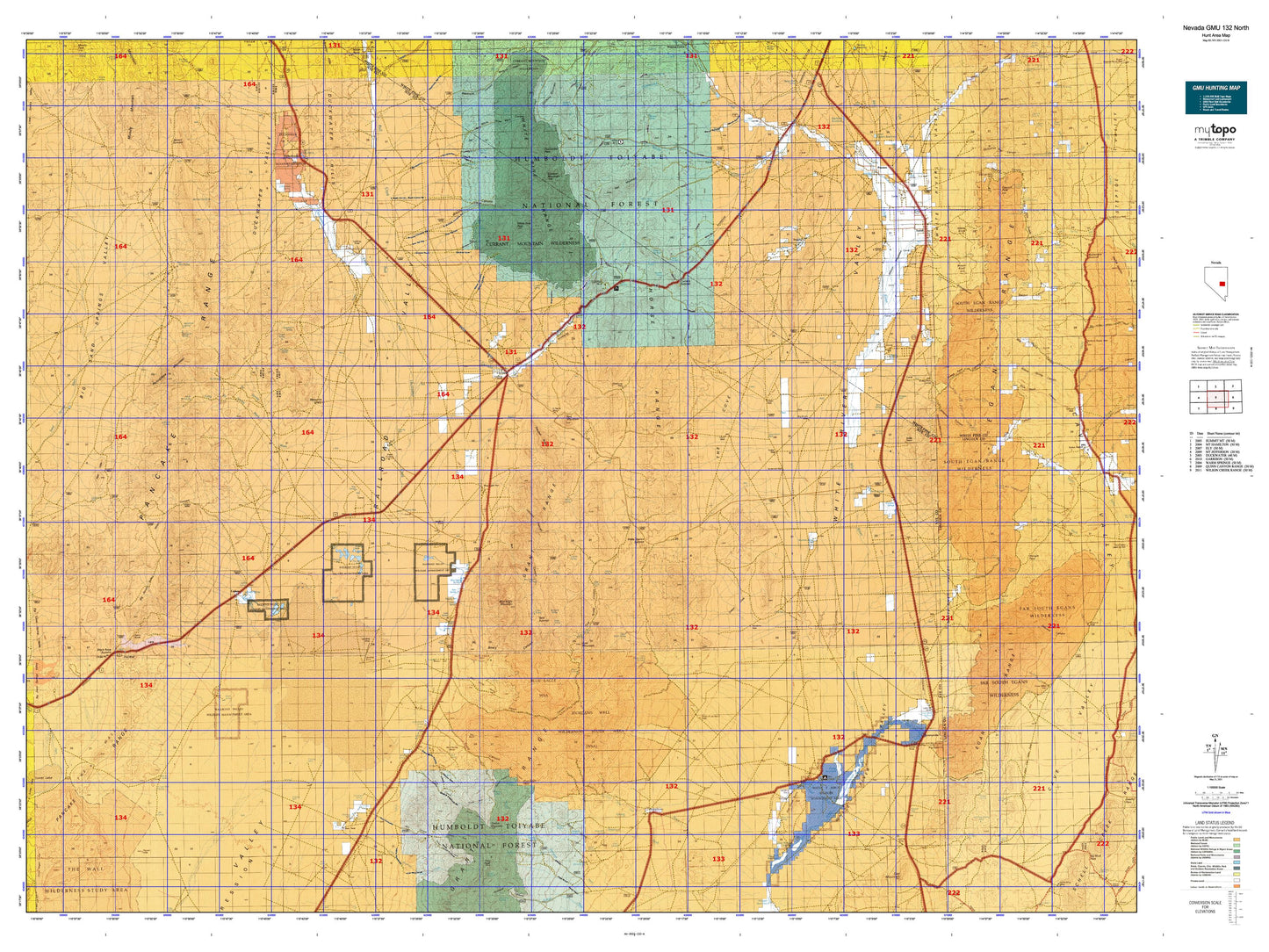
Nevada GMU 132 North Map
Couldn't load pickup availability
Hunting unit map of Nevada Game Management Unit 132-N with topographic lines and unit boundaries. This topo map features UTM / MGRS and Latitude/Longitude grids, plus public land ownership. It comes folded on waterproof paper. Be fully prepared for your hunt with a MyTopo GMU map!.
This map contains the following named places: 89314,89317,Adams-McGill Reservoir,Adams-McGill Reservoir Dam,Ala-Mar East Mine,Ala-Mar West Mine,Albert Spring,Allred,Andrew Spring,Angleworm Ranch,Arnoldson Spring,Bacon Flat,Bald Mountain,Balsam Canyon,Barnes,Barrel Spring,Beaty Canyon,Beaty Spring,Big Round Valley,Big Sand Springs Valley,Big Spring,Big Well Ponds,Black Canyon Wash,Black Rock Spring,Black Rock Summit,Blackjack Reservoir,Blind Spring,Blind Spring Basin,Blue Eagle Mountain,Blue Eagle Pass,Blue Eagle Ponds,Blue Eagle Ranch,Blue Eagle Spring,Box Canyon,Bradshaw Ranch,Brady Wash,Broom Canyon,Brown Knoll,Brown Knoll Reservoir,Brown Summit,Brown Summit Reservoir,Bull Creek,Bull Creek Reservoir,Butterfield Marsh,Callaway Ranch,Carter Ranch,CCC Camp,Christmas Tree Canyon,Cold Spring Canyon,Collins Meadow,Cottonwood Canyon,Crows Nest,Currant,Currant Creek,Currant Creek Forest Service Recreation Site,Currant Mining District,Currant Mountain,Currant Mountain Wilderness,Currant Ranch Airport,Currant Summit,Dacey Dam,Dacey Reservoir,Davis Ranch,Douglas,Douglas Point,Dry Basin,Duckwater,Duckwater Airport,Duckwater Cemetery,Duckwater Creek,Duckwater Division,Duckwater Hills,Duckwater Peak,Duckwater Reservation,Duckwater Valley,Eagle Springs Oil Field,El Padre Mine,Ellison Creek,Ellison Mine,Ellison Mining District,Emigrant Station,Eph Creek,Evans Field,Far South Egans Wilderness,Fisher Ranch,Florio Outrider Cabin,Forest Home,Forest Home Creek,Forest Home Reservoir Number 2,Forest Home Reservoir Number 4,Forest Home Reservoir Number 5,Forest Moon Ranch,Gardner Ranch,Gold Point,Gold Point Mine,Grant Canyon,Grant City,Grant Mining District,Grant Range,Grant State Game Refuge,Gray Eagle Mine,Hay Meadow Dam,Hay Meadow Reservoir,Heath Canyon,Hendrix Mine,Hendrix Ranch,Horse Range,Horse Spring Hills,Hot Creek,Hot Creek Butte,Hot Creek Campground,Ike Spring Wash,Irwin Camp,Irwin Canyon,Irwin Mine,Jakes Wash,Johnson Boys Mine,Johnson Canyon,Kern Creek,Lani Ranch,Lava Bed Catch Basin,Little Ike Spring Wash,Little Meadows Creek,Locke Mine,Lockes,Lockes Ponds,Lone Pine Swale,Lower Cove,Lower Preston Reservoir,Lunar Lake,Lund,Lund Census Designated Place,Lund Holding Corral,Lund Reservoir,Lund Township,Manzone Ranch,Manzonie Dam,Manzonie Reservoir,Martins Creek,McCubes,McDonalds,Meteorite Crater,Midland Trail,Moon River,Moon River Ranch,Mud Spring Basin,Murphy Wash,Narrows Catch Basin,Ninemile Canyon,Ninemile Mountain,North Fork Irwin Canyon,North Fork Troy Canyon,Nye Mine,Old English Mine,Ox Spring Wash,Pancake Range,Peacock Ranch,Portuguese Mountain,Post Canyon,Preston,Preston Census Designated Place,Ragged Ridge,Railroad Valley Wildlife Management Area,Red Hills,Red Mountain,Red Mountain Wilderness,Rex-Pine Mine,Riorden,Ruppes Place,Sand Springs Wash,Sandy Wash,Sawmill Canyon,Sawmill Peak,Schoolhouse Canyon,Seymour,Seymour Mining District,Sharp Ranch,Sheep Pass Canyon,Sheep Pass Corral,Shingle Pass,Shingle Peak,Silver Spring Station,Smith Creek,South Egan Range Wilderness,South Fork Irwin Canyon,South Fork Troy Canyon,South Fork Troy Creek,Stockville,Stone Cabin,Sunnyside,Sunnyside Creek,Sunnyside Whipple Ranch,Sunnyside-Kirch Wildlife Management Area Airport,Tank Summit,Teaspoon Wash,Terrell Mine,The Big Wash,The Cove,The Wall,Timber Mountain,Titus Ranch,Trap Spring Oil Field,Trough Spring Canyon,Troy,Troy Canyon,Troy Creek,Troy Mine,Troy Mining District,Troy Peak,Tule Field Reservoir,Twin Canyon,Volcanic Hill,Warm Springs Ranch,Wayne E Kirch Wildlife Management Area,Wells Station,Wells Station Summit,West Fork Grant Canyon,Whipple Peak,Whipple Ranch,White Horse Pasture,White Knoll,White Knoll Reservoir,White Pine Peak,White Pine Range,White Pine Ranger District,White River,White River Campground,White River Pass Canyon,White River Range,White River Reservoir,Wilhoites Peak,Wilson Meadows,Windous Butte,Windous Mine,Wood Canyon