MyTopo
Nevada GMU 133 Map
Couldn't load pickup availability
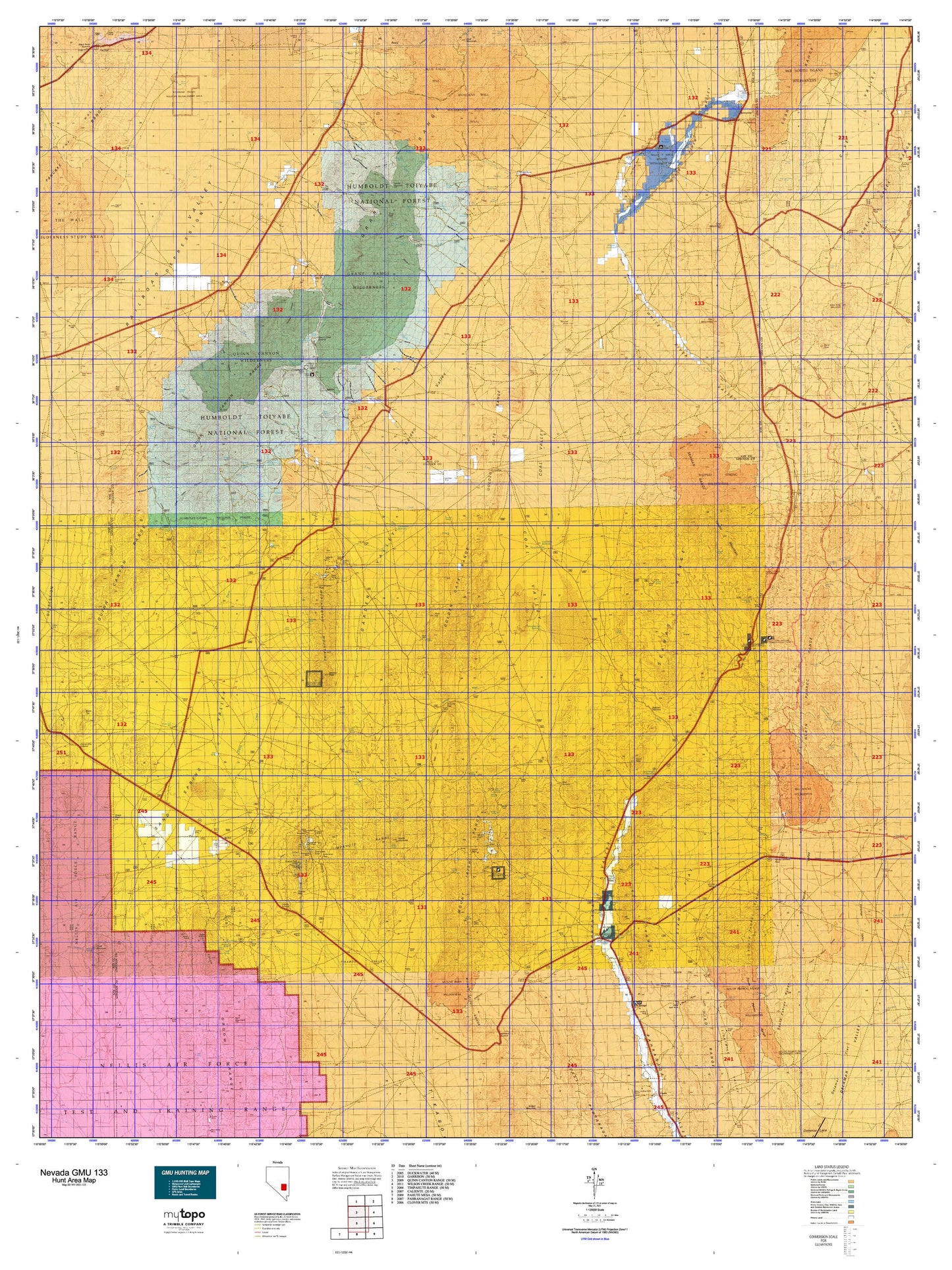
Hunting unit map of Nevada Game Management Unit 133 with topographic lines and unit boundaries. This topo map features UTM / MGRS and Latitude/Longitude grids, plus public land ownership. It comes folded on waterproof paper. Be fully prepared for your hunt with a MyTopo GMU map!.
This map contains the following named places: 89017,Able Reservoir,Adams-McGill Reservoir,Adaven,Alamo Division,Alamo Township,Andies Mine,Apple Reservoir,Ash Springs,Bald Mountain,Barton Creek,Basin and Range National Monument,Big Creek,Big Creek Ranch,Big Creek Reservoir,Big Rocks Wilderness,Big Spring Wash,Blind Spring Basin,Bordoli Creek,Bordoli Ranch,Brady Wash,Bruno Creek,Burnt Peak,Butterfield Salt Beds,Carpenter Pipe Line,CCC Camp,Chalk Reservoir,Charco Pit Reservoir,Cherry Creek,Cherry Creek Forest Service Facility,Cherry Creek Forest Service Recreation Site,Chocolate Drop,Coal Valley,Coal Valley Holding Field,Coal Valley Reservoir,Cold Springs Wash,Cottonwood Creek,Cottonwood Reservoir,Cottonwood Wash,Coyote,Coyote Peak,Coyote Summit,Crescent,Crescent Mill,Crescent Mine,Crows Nest,Crystal Springs,Crystal Wash,Cyanide Reservoir,Dacey Reservoir,Davis Cabin,Davis Creek,Davis Mine,Delamar Perlite Mine,Delamar Wash,Don Dale Mine,Don Dale Mining District,Dresser Mine,Dry Basin,Dry Creek,East Coal Valley Reservoir,Eds Hill,El Cortez Mine,Emerald Mine,Far South Egans Wilderness,Forest Home,Forest Home Creek,Forest Moon Ranch,Fossil Peak,Fox Mountain,Fox Mountain Reservoir,Freiberg Mining District,Freiburg,Freiburg Mine,Frenchy Lake,Gap Mountain,Garden Valley,Garden Valley Reservoir,Gardner Ranch,Grant City,Grant Mining District,Grant Range Wilderness,Grant State Game Refuge,Grants Peak,Hay Meadow Reservoir,Helene Wash,Hendrix Ranch,Higrade Mine,Hiko,Hiko Mill,Hooper Creek,Hot Creek,Hot Creek Butte,Hot Creek Campground,Indian Peak,Iron Cap Mine,Irwin Camp,John Wright Reservoir,Key Pittman Wildlife Management Area,Knoll Pond Reservoir,Leviathan Cave Geologic Area,Lincoln County,Lincoln Mine,Lincoln Mine PIBAL Station,Line Reservoir,Little Cherry Creek,Little Meadows Creek,Logan,Logan Creek,MacKay Reservoir,Main Wash 6 Reservoir,Mayflower Mine,Meeker Peak,Melbourne Mine,Midland Trail,Monkey Wrench Wash,Monte Mountain,Moon River,Moon River Ranch,Mount Irish,Mount Irish Wilderness,Mud Spring Basin,Murphy Gap Reservoir,Murphy Wash,Mystery Mountain,Nesbitt Lake,Nesbitt Ranch,Nesbitt Reservoir,New East Ditch,North Fork Cottonwood Creek,Norton Fence,Number Four Ditch,Number One Ditch,Number Three Ditch,Nyala,Nyco Mine,Old Tem Piute Mine,Onada Reservoir,Oneota,Ora Lovell Mine,Ox Spring Wash,Pahranagat Mining District,Pahroc Valley,Penoyer Farms,Pine Creek,Pine Creek Ranch,Quail Reservoir,Queen of the West Mine,Quinn Canyon Wilderness,Rachel,Red Hill,Red Rock Reservoir,Rock Hill,Rosario Mine,Rye Patch Reservoir,Sand Creek,Sand Spring Valley,Sand Springs,Sanderson Mountain,Scofield Wash,Seaman Wash,Seymour,Seymour Mining District,Shannon Queen Mine,Sharp Peak,Sharp Ranch,Sherwood Wash,Silver City,Silver Hill,Silver King,Silver King Mine,Silver King Mining District,Silver King Mountain,Skull Mountain,South Fork Cottonwood Creek,South Fork Pine Creek,South Fork Troy Creek,South Pahroc Range Wilderness,Southpaw Mine,Southside Reservoir,Spring Creek,Stairstep Mountain,Steele Mine,Stewart Quarry,Stone Corral Well Reservoir,Sunbeam Mine,Sundown,Sunnyside,Sunnyside Creek,Sunnyside Whipple Ranch,Swiss Bob Reservoir,Table Top Mountain,Teaspoon Wash,Tem Piute Mining District,Tempiute,Tempiute Historic Site,Tempiute Mountain,Thiriot Reservoir,Timber Mountain,Timber Mountain Pass Corral,Tooley Reservoir,Troy,Troy Creek,Troy Mining District,Troy Mountain,Troy Peak,Tule Field Reservoir,Tule Reservoir,Tungsten Reservoir,Twin Spring Reservoir,Uhalde Ranch,Uhalde Reservoir,United Cattle Ranch,Volcanic Hill,Wadsworth Ranch,Walch Ranch,Warm Springs Ranch,Wayne E Kirch Wildlife Management Area,Weepah Spring Wilderness,Welch Ranch,Wheatgrass Wash,Whipple Peak,Whipple Ranch,Whipple Reservoir,White River,White River Reservoir,White River Sink,White Sage Reservoir,Willow Creek,Willow Creek Mining District,Windmill Number One,Windmill Number Two,Worthington Mountains Wilderness,Worthington Peak,Y-Z Mine


