MyTopo
Nevada GMU 134 Map
Couldn't load pickup availability
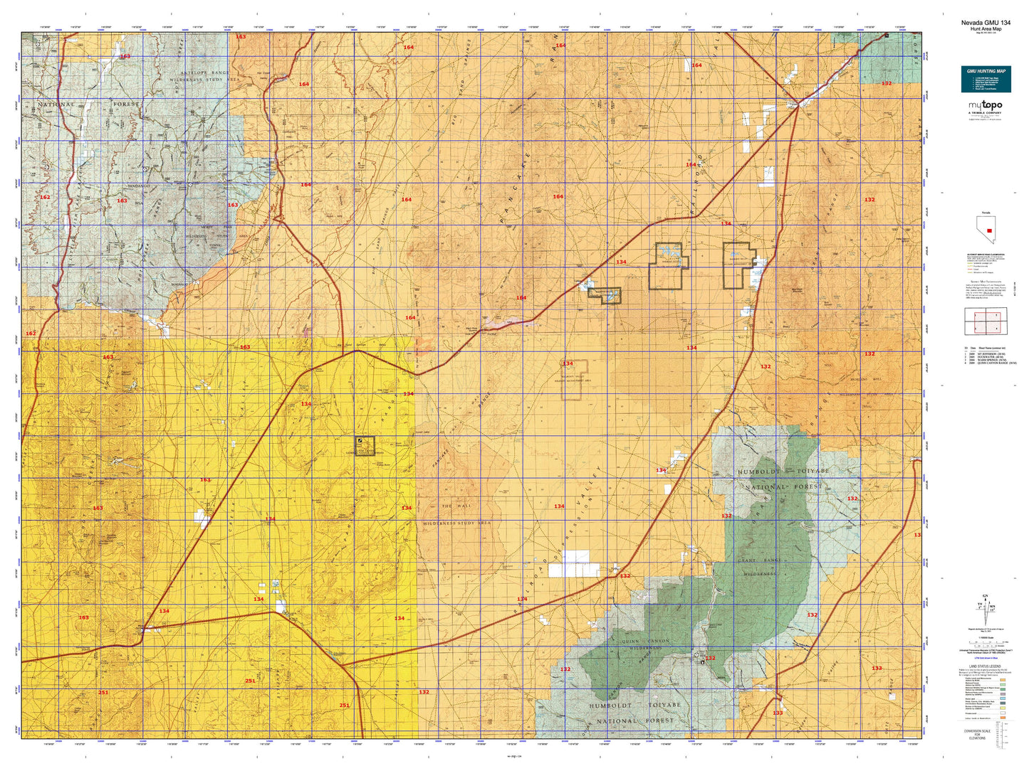
Hunting unit map of Nevada Game Management Unit 134 with topographic lines and unit boundaries. This topo map features UTM / MGRS and Latitude/Longitude grids, plus public land ownership. It comes folded on waterproof paper. Be fully prepared for your hunt with a MyTopo GMU map!.
This map contains the following named places: 89049,A and B Mine,Adaven,Air Shaft Ridge,Allred,American Eagle Mine,Amethyst Peak,Aspen Peak,Basalt Butte,Bay State Mill,Bay State Mine,Big Creek,Big Creek Ranch,Big Creek Reservoir,Big Fandango,Big Fault Mesa,Big Fault Ridge,Big Round Valley,Big Well Ponds,Black Beauty Mesa,Black Diamond Mill,Black Hawk Mine,Blind Spring Basin,Blue Eagle Mountain,Blue Eagle Ponds,Blue Eagle Ranch,Blue Eagle Spring,Blue Jay Highway Maintenance Station,Bordoli Creek,Bordoli Ranch,Brady Wash,Break Mine,Buckskin Point,Buckwheat Rim,Bull Creek,Bunker Hill Mine,Butterfield Ranch,Butterfield Salt Beds,Cabin Creek,Callaway Ranch,Casket Mine,Cedar Mine,Chaos Creek,Chaos Knob,Charcoal Basin,Cherry Creek Forest Service Facility,Cherry Creek Forest Service Recreation Site,Cine Mountain,Citadel Mountain,Clifford Mine,Clifford Mining District,Clover Creek,Confusion Hills,Crescent Hogback,Crows Nest,Cruiser Point,Cunningham Mine,Currant,Currant Creek,Currant Mining District,Danville Creek,Dead Cow Ridge,Devils Cave Ridge,Dimick Mine,Dry Basin,Dry Creek,Duckwater Creek,Duckwater Division,Eagle Springs Oil Field,Echo Canyon Dam,Echo Canyon Reservoir,El Padre Mine,Falani Ranch,Fish Lake Valley Creek,Fishhook Ridge,Flagstaff Mountain,Fourmile Canyon Kilns,Gilmore Mine,Goblin Knobs,Grant City,Grant Mining District,Grant Range,Grant Range Wilderness,Gray Eagle Mine,Green Monster Creek,Halligan Mesa,Heart Hills,Helena,Hicks Station Wash,Hidden Mountain,Higrade Mine,Hooper Creek,Horse Spring Hills,Hot Creek,Hot Creek Mining District,Hot Creek North Summit,Hot Creek Ranch,Hot Creek Range,Hotcreek,Ike Spring Wash,Indian Garden Creek,Indian Jim Mine,Irwin Camp,Irwin Mine,Kaiser Tunnel,Kern Creek,Keystone,Keystone Mine,Lava Bed Catch Basin,Little Cherry Creek,Little Fandango,Little Fish Lake,Little Fish Lake Ranch,Little Ike Spring Wash,Little Lunar Cuesta,Little Meadows Creek,Little Rawhide Mountain,Locke Mine,Lockes,Lockes Ponds,Lower Fandango,Lower Town,Lunar Cuesta,Lunar Lake,Luther Waddles Wash,M and M Mine,Magnolia Mine,Mahogany Peak,Mamouth Mine,Mayflower Mine,McDonalds,Melbourne Mine,Middle Fork Chaos Creek,Midland Trail,Monitor Peak,Moores Station,Moores Station Buttes,Moores Station Wash,Morey,Morey Mine,Morey Mining District,Morey Peak,Mount Airy Mine,Mountain View,Mountain View Mill,Mud Spring Basin,Murphy Wash,Narrows Catch Basin,Needle Range,Needles Catch Basin,New Philadelphia,North Fork Cabin Creek,North Kidney Butte,Nyala,Nye Mine,Old Dominion Stamp Mill,Old Dugan Ranch,Old English Mine,Old Page Place,Orange Lichen Creek,Ox Spring Wash,Page Mine,Palisade Mesa,Peach Peak,Petroglyph Butte,Point of Rocks Mine,Portuguese Mountain,Queen of the West Mine,Quinn Canyon Range,Quinn Canyon Wilderness,Ragged Ridge,Railroad Valley Wildlife Management Area,Rattlesnake Maintenance Station,Rawhide Mountain,Red Hill,Red Hills,Red Ring Mountain,Rhyolite Hills,Sand Springs Wash,Seymour,Seymour Mining District,Sharp Ranch,Shingle Buttes,Shoshone Creek,Sixmile Canyon Kilns,Slanted Buttes,South Fork Chaos Creek,South Fork Pine Creek,South Fork Troy Creek,South Kidney Butte,Spring Creek,Squaw Hills,Stairstep Mountain,Stone Corral Well Reservoir,Tank Summit,Terrell Mine,The Big Wash,The Needles,The Wall,Timber Mountain,Titus Ranch,Tod Wattle Summit,Topside Mine,Trap Spring Oil Field,Treadwell Yukon Mine,Troy,Troy Creek,Troy Mine,Troy Mining District,Troy Mountain,Troy Peak,Twin Canon,Twin Peaks,Twin Springs Ranch,Twin Springs Slough,Two-G Mine,Tybo,Tybo Charcoal Kilns,Tybo Creek,Uhalde Ranch,Uhalde Reservoir,United Cattle Ranch,Upper Fish Lake,Upper Hot Creek Ranch,Upper Town,Wadsworth Ranch,Wagon Johnnies Ranch,Warm Springs,Water Tank Mine,Western Extension Mine,Wide Valley,Williams Ridge,Willow Creek,Willow Creek Mine,Wist Mine


