MyTopo
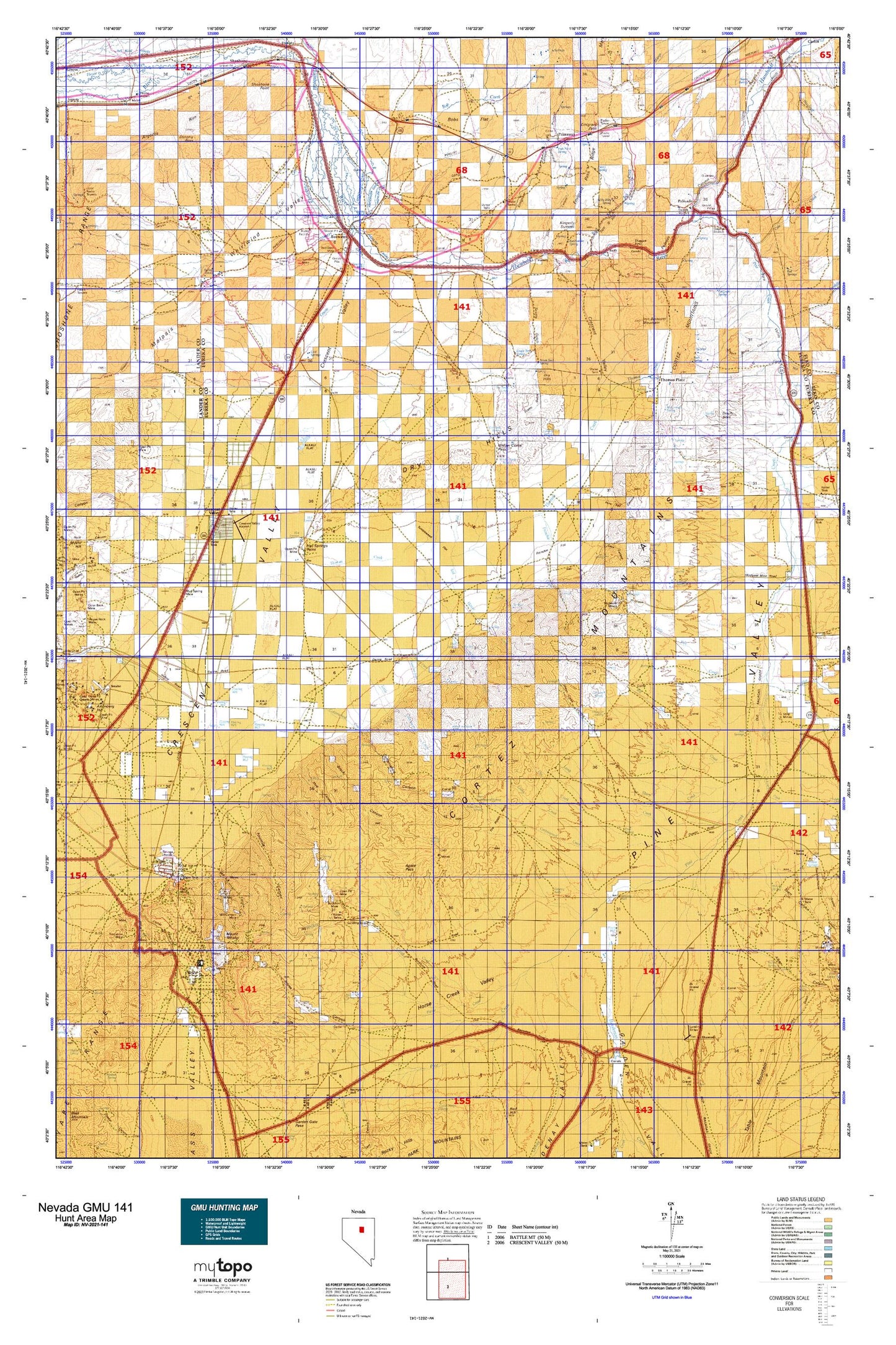
Nevada GMU 141 Map
Couldn't load pickup availability
Hunting unit map of Nevada Game Management Unit 141 with topographic lines and unit boundaries. This topo map features UTM / MGRS and Latitude/Longitude grids, plus public land ownership. It comes folded on waterproof paper. Be fully prepared for your hunt with a MyTopo GMU map!.
This map contains the following named places: 89821,89822,Agate Pass,Aiken Canyon,Allison Ranch,Anderson Canal,Argenta Rim,Artic Mine,Barth,Barth Mine,Beaowawe Gate,Bell Ranch,Benjamin Harrison Mine,Beowawe,Beowawe Division,Beowawe Indian Cemetery,Beowawe Mining District,Beowawe Township,Berlin Mine,Big Field Number One,Big Field Number Two,Big Pole Creek,Big Pole Spring,Black Rock Canyon,Blackburn,Blackpoint Spring,Bob Creek,Bob Creek Canyon,Bobs Flat,Brock Canyon,Buck Rake Jack Creek,Buckhorn,Buckhorn Mine,Buckhorn Mine Airport,Buckhorn Mining District,Buckhorn Spring,Bullion Hill Mine,Cabin Spring,Caledonia Mine,Cave Canyon,Cherry Springs,Cherry Tree Spring,Cluro,Cold Springs,Cole Creek,Cooks Creek,Copper Canyon,Corbett Canal,Corral Canyon,Cortez,Cortez Airstrip,Cortez Canyon,Cortez Gold Mine,Cortez Mine,Cortez Mountains,Cortez-Mill Canyon Mining District,Cottonwood Canyon,Cottonwood Creek,Coyote Creek,Crescent Valley,Crescent Valley Airport,Crescent Valley Census Designated Place,Curlow Flat,Curlow Spring,D Filippini Ranch,Dago Tunnel,Dean Ranch,Dean Spring Number Two,Deer Canyon,Deer Creek,Deer Spring,Denay Creek,Denay Valley,Devils Gate,Dewey Dann Creek,Dewey Dann Ranch,Doc Creek,Dry Creek,Dry Hills,Duff Creek,Duff Ranch,Duff Spring,Duggan Spur,Dunphy Pass,Dwyer Dam,Edwards Creek,Emigrant Canyon,Emigrant Pass,Emigrant Pass Ridge,Emigrant Spring,Empire State Mine,Falconer Mine,Ferdelford Creek,Fire Creek,Fish Pond Spring,Fitzgerald Mine,Florio Spring Number Eight,Florio Spring Number Five,Florio Spring Number Four,Florio Spring Number Seven,Florio Spring Number Three,Fourmile Canyon,Frenchie Creek,Frenchie Flat,Frenchie Ranch,Fuzzy Spring,Garden Valley,Gerald,Goyeneche Spring Number Six,Goyeneche Spring Number Three,Goyeneche Spring Number Two,Hall Ranch,Hand-me-down Creek,Hand-me-down Spring,Harney,Henderson Creek,Highline Canal,Highway Spring,Horse Canyon,Horse Creek,Horse Creek Valley,Horse Heaven,Horse Ranch,Horseshoe Ranch,Horseshoe Station,Hot Creek,Hot Springs,Hot Springs Point,Hot Springs Point Mine,Indian Creek,Indian Ranch,Iron Blossom Mountain,Johnson Ranch,Kingerly Summit,Knight Ranch,Ladoga,Lamb Creek,Last Chance Mine,Lewis Canyon Mines,Linka Creek,Little Cottonwood Creek,Little Pole Creek,Lodi,Lone Pine Mine,Long Draw,Lower Cottonwood Spring,Maidens Grave Cemetery,Malpais,McCormack Spring,McCoy Spring,Merchant Canal,Mill Canyon,Mill Canyon Mine,Mill Creek,Mineral,Modarelli Mines,Modarelli-Frenchie Creek Mining District,Moores Spring,Mosel,Mount Tenabo,Mount Tenabo Mine,Mud Spring Mine,Mule Canyon,Neil Creek,New York Mine,Old Thomas Spring,One Tank Spring,Onondaga Mine,Palisade,Palisade Canyon,Palisades Four Dam,Palisades Three Dam,Palisades Two Dam,Pine Creek,Pine Valley,Pioneers Grave,Pony Creek,Pony Trail Canyon,Potato Patch Spring,Primeaux,Primeaux Canyon,Primeaux Creek,Quartz Spring,Raine Ranch,Rattlesnake Spring,Red Devil Mine,Rimrock Spring,Rimrock Springs,Rock House,Rock Spring,Rock Spring Canyon,Rocky Canyon,Rose Dam,Rose Ranch,Safford Canyon,Safford Mining District,Saint Louis Mine,Sansening Mine,Sansening Ranch,Scotts Gulch,Secquira Spring,Seven Tank Spring,Shannon,Sheep Creek,Sheep Creek Canyon,Shoshone Point,Sidehill Blue Spring,Single Tank Spring,Sod House Creek,Sod House Ranch,South Gate Spring,Stone Wall Canyon,Thatcher Spring,The Potato Patch,Thomas Creek,Thomas Place,Trout Creek,Tub Spring,Tub Spring Gulch,Tumbleweed Flat,Turquoise Mine,Twin Summit,Two Hill Canyon,Tyrol,Valley View Mine,Warm Spring,West Fork Mill Creek,Westside Ditch,Whirlwind Valley,White Horse Mine,Willow Corral Pass,Willow Creek,Willow Spring,Willy Billy Spring,Zendi Mine