MyTopo
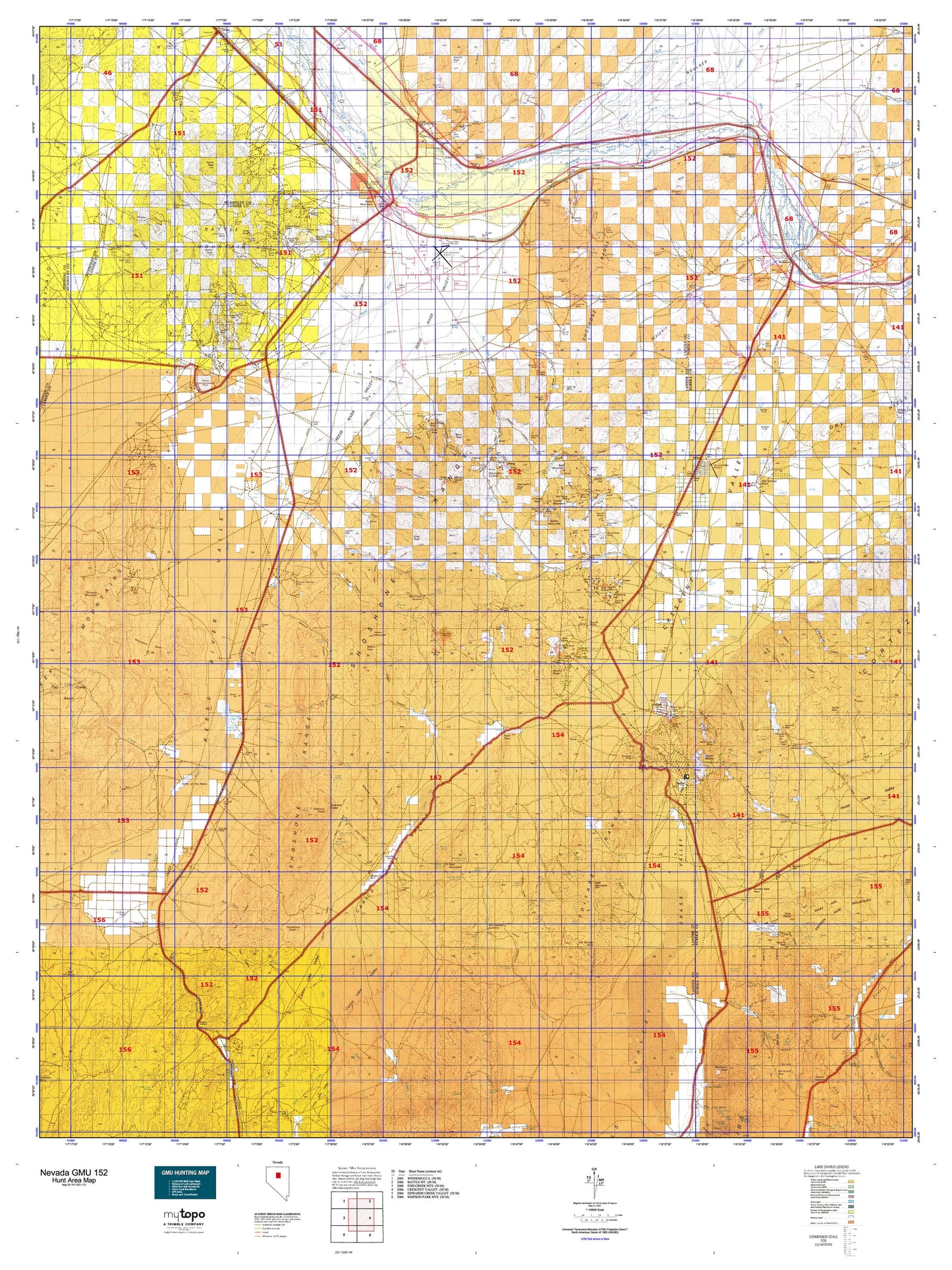
Nevada GMU 152 Map
Couldn't load pickup availability
Hunting unit map of Nevada Game Management Unit 152 with topographic lines and unit boundaries. This topo map features UTM / MGRS and Latitude/Longitude grids, plus public land ownership. It comes folded on waterproof paper. Be fully prepared for your hunt with a MyTopo GMU map!.
This map contains the following named places: 25 Ranch,89820,89821,Allen Ranch,Allison Ranch,Altenburg Hill,Antler Peak,Argenta,Argenta Butte,Argenta Mining District,Argenta Point,Argenta Ranch,Argenta Siding,Argenta Township,Bailey,Bald Mountain,Bannock,Batemans Creek,Battle Creek,Battle Mountain,Battle Mountain Division,Battle Mountain Mining District,Battle Mountain Radio Range Station,Battle Mountain Reservation,Baumann Ranch,Bens Peak,Beowawe,Beowawe Mining District,Betty O'Neal,Blanco,Blossom Ranch,Blue House Slough,Bob Creek,Bobtown,Boulder Creek,Bradleys Ranch,Bridges,Broyles Ranch,Buckbrush Cabin,Buckhorn,Buckhorn Mining District,Buckingham Camp,Buffalo Valley Mining District,Bullion,Bullion Mining District,Bullion Mountain,Caetano Ranch,Cain Creek,Canyon,Cape Horn,Carico Lake,Carico Lake Ranch,Chesser Mountain,Chiara Ranch,Chicken Creek,Childress Ranch,Cooks Creek,Copper Basin,Copper Canyon Placer Camp,Cortez,Cortez-Mill Canyon Mining District,Cottonwood Creek,Coyote Creek,Crescent Valley,D Filippini Ranch,Damele Ranch,Dean,Dean Ranch,Dewey Dann Creek,Dewey Dann Ranch,Dewitt Mill,Dillon,Dome Peak,Dry Canyon Wash,Dry Hills,Duck Creek,Duff Creek,Duff Ranch,Dunphy,Dunphy Ranch,Eagle Mill,East Fork Rock Creek,Elder Creek,Elephant Head,Ferrel Station,Ferris Creek,Fire Creek,Fish Creek,Fish Creek Ranch,Francis Cabin,Frisbie,Galena,Gay Mining Camp,Goat Peak,Gold Acres,Gold Quartz,Granite Mountain,Grouse Creek,Hall Creek,Hand-me-down Creek,Harry Creek,Havingdon Peak,Healey Cabins,Highland Chief Mill,Hilltop,Hilltop Mining District,Holcomb Cabin,Home Ranch,Horse Creek Valley,Horse Mountain,Horse Ranch,Horseshoe Basin,Horseshoe Ranch,Horseshoe Station,Hot Springs Point,Hot Springs Ranch,Indian Creek,Indian Ranch,Iowa Creek,Isaacs Ranch,Jenkins,Jenkins Ranch,Johnson Ranch,Jory Ranch,Kampos,Keystone,Ladoga,Lander,Lander County,Lander County Yard,Lewis,Lewis Bens Creek,Lewis Creek,Lewis Junction,Lewis Mining District,Lewis Peak,Licking Creek,Licking Ranch,Little Cottonwood Creek,Little Giant Mill Creek,Long Peak,Lower Gimmel Field,Mack Creek,Marvel Ranch,Maysville,Maysville Summit,McClusky Creek,McCoy,McCoy Mining District,Middle Fork Mill Creek,Middletown,Mill Canyon,Mill Creek,Mill Gulch,Mosel,Moss Creek,Mote Siding,Mound Spring Station,Mount Caetano,Mount Lewis,Mount Tenabo,Mud Springs,Muleshoe Ranch,Myers Hill,Neil Creek,Nevin,North Battle Mountain,North Fork Mill Creek,North Fork Trout Creek,North Peak,O'Haras Peak,Old Battle Mountain,Old California Trail,Oyarbide Ranch,Pinnacle Mountain,Pittsburgh,Piute,Powers Ranch,Red Mountain,Red Mountains,Red Top Mountain,Rennox,Rixies,Roaring Creek,Roberts Mining District,Rock Creek,Rock House,Rocky Hills,Rosny,Route of California Trail,Ruffi Ranch,Russell Hay Camp,Sansening Ranch,Sheep Creek,Shoshone,Shoshone Mesa,Shoshone Point,Shwin Ranch,Slaughterhouse Field,Slaven Creek,Sod House Creek,South Fork Mill Creek,Squaw Butte,Starr,Starr Grove Mill,Sterritt Peak,Stone Cabin Basin,Stony Point,Telluride,TeMoak Indian Housing,Tenabo,The Cedars,Thomas Creek,Tonkin,Tonkin Ranch,Trout Creek,Trout Creek Ranch,T-S Ranch,Twin Peaks,Upper Gimmel Field,Utah Mine Camp,Valley of the Moon,Valley of the Moon Ranch,Vicks Stage Station,Watts,Waukine Ranch,Weber Ranch,Welch Ranch,West Fork Ferris Creek,West Fork Mill Creek,West Fork Rock Creek,Wholey Ranch,Willow Creek,Willow Creek Reservoir,Wilson Ranch