MyTopo
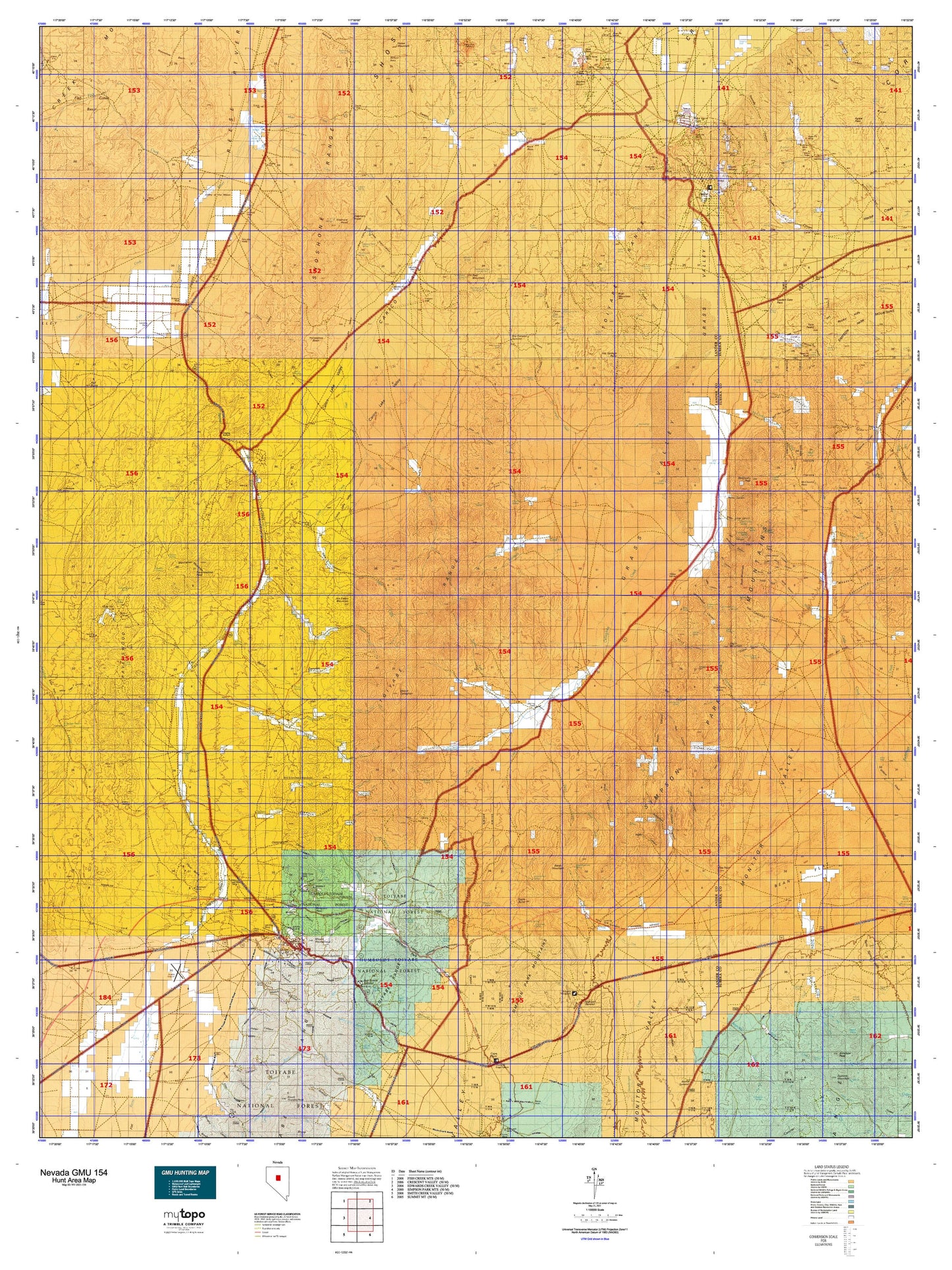
Nevada GMU 154 Map
Couldn't load pickup availability
Hunting unit map of Nevada Game Management Unit 154 with topographic lines and unit boundaries. This topo map features UTM / MGRS and Latitude/Longitude grids, plus public land ownership. It comes folded on waterproof paper. Be fully prepared for your hunt with a MyTopo GMU map!.
This map contains the following named places: 1862 Overland,89310,Ackerman Canyon Ranch,Allen Ranch,Allison Ranch,Amador,Antelope Peak,Arena Ranch,Austin,Austin District Ranger Office,Austin Division,Austin Township,Bade Creek,Bade Flat State Game Refuge,Bald Mountain,Barton Creek,Bates Mountain,Battle Mountain to Austin Stage Route,Baumann Ranch,Belle Wilder Incline,Big Creek,Birchum Slough,Blackbird,Blackbird Creek,Blackbird Ranch,Bob Scott Forest Service Recreation Site,Bob Scotts Historical Site,Bobtown,Boone Creek,Boone Creek Ranch,Brackney Ranch,Bradleys Ranch,Bridges,Brooks Mill,Buck Mountain,Buckhorn,Buckhorn Mine,Buckhorn Mining District,Buels Mill,Burtons Ranch,Butte Mill,Caetano Ranch,Cain Creek,Callaghan Creek,Callaghan Ranch,Camp Station,Canon City,Canyon,Cape Horn,Cape Horn Overland Stage Station,Carico Lake,Carico Lake Ranch,Carter Ranch,Caton Ranch,Catons,Central Hill,Clarks,Clifton,Clinton,Confidence Hoisting Works,Corral Canyon Creek,Cortez,Cortez Mine,Cortez-Mill Canyon Mining District,Cottonwood Creek,Cowboy Rest,Cowboy Rest Creek,Cowboy Rest Ranch,Crooked Canyon Creek,Cummings Lease Tunnel,Cummings Tunnel,Curtis,Curtis Shaft,Deep Creek Station,Dry Canyon Wash,Dry Creek,Dry Creek Ranch,Dry Creek Station,Dry Hills,Dudley B Shaft,Duff and Company Mill,Eagle Butte,Elder Creek,Elephant Head,Fagin Mountain,Fandango Hill,Ferguson Creek,Ferguson Ranch,Fish Creek,Fish Creek Basin,Fish Creek Ranch,Francis Cabin,Frontier,Frost Shaft,Gandolfo Ranch,Geneva,Givens Ranch,Gold Acres,Gondolfo Ranch,Grass Valley,Grass Valley Ranch,Grimes Hills,Grimes Ranch,Grouse Creek,Gund Ranch,Gweenah,Hall Creek,Hall Creek Ranch,Hattie Mill,Hickison Petroglyth Recreation Site,Hildreths Mill,Hiller,Horse Creek,Horse Ranch,Horseshoe Basin,Hot Springs Point,Hot Springs Ranch,Indian Creek,Indian Ranch,Iowa Canyon Ranch,Iowa Canyon Reservoir,Iowa Creek,Isaacs Ranch,Italian Creek,Jackass Creek,Jacobsville,Joe Eason Mountain,Johnson Ranch,Kelly Creek,Keystone,Keystone Mill,Lake Ranch,Lander County,Ledlie,Luetgen Tunnel,Marshall Basin,McClusky Creek,McClusky Peak,Mettacom Mill,Mill Canyon,Mill Canyon Mine,Mill Creek,Mitchels Ranch,Moss Creek,Mount Caetano,Mount Callaghan,Mount Prometheus,Mount Tenabo,Nevin,North Branch Horse Creek,North Fork Italian Creek,North Fork Silver Creek,North Fork Skull Creek,North Fork Steiner Creek,North Fork Willow Creek,North Hill,Ox Corral Creek,Parrots Mill,Paxton Incline,Peak Number 4,Pedlar Creek,Powers Ranch,Racetrack Ranch,Ralstons Mill,Ravenswood,Ravenswood Mining District,Ravenswood Peak,Ravenswood Station,Red Bird Mine,Red Butte,Red Hills,Red Mountain,Red Mountains,Reese River Mining District,Reynolds Creek,Roberts Mining District,Rock House,Rocky Hills,Rosebush Creek,Ruby Incline,Rundberg Incline,Santa Fe Ranch,Shagnasty,Shagnasty Basin,Sherman Hoisting Work,Silver Age House,Silver Creek,Silver Creek Ranch,Simpson Park Station,Skookum,Skookum Mining District,Skull Creek,Skunk Ranch,South Fork Willow Creek,South Hill,Spencer,Squaw Butte,Steiner Creek,Steiner Ranch,Stone Cabin Basin,Stoneberger Creek,Telegraph Peak,The Cedars,The Point,Three Bar,Three Bar Ranch,Tommy Incline,Trogan Shaft,Twin Peaks,Underwood Creek,Union Hill,Valley of the Moon,Valley of the Moon Ranch,Vaughn Ranch,Vaughns,Vias Ranch,Vicks Stage Station,Walters Ranch,Walti Ranch,Water Canyon Creek,Watts,Waukine Ranch,West Fork Hall Creek,West Fork Mill Creek,White House,White House Ranch,Wholey Ranch,Wiggins,Willow Creek,Willow Creek Ranch,Willows Ranch,Wolf Ranch,Woods Reservoir,X-Ray Shaft,Yankee Blade