MyTopo
Nevada GMU 184 Map
Couldn't load pickup availability
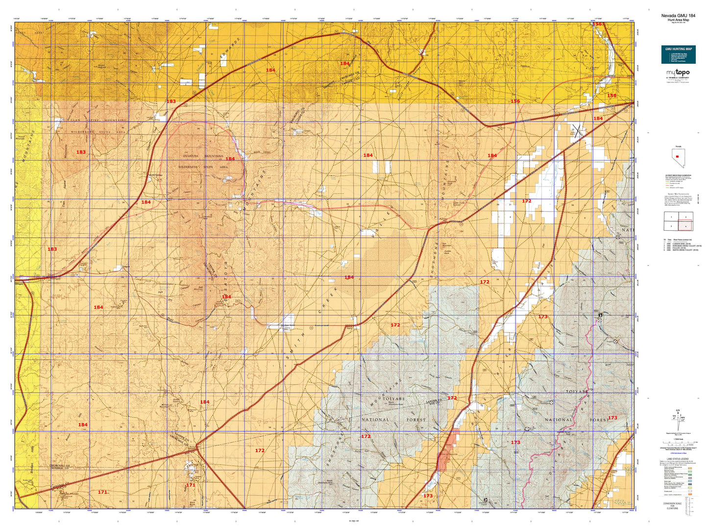
Hunting unit map of Nevada Game Management Unit 184 with topographic lines and unit boundaries. This topo map features UTM / MGRS and Latitude/Longitude grids, plus public land ownership. It comes folded on waterproof paper. Be fully prepared for your hunt with a MyTopo GMU map!.
This map contains the following named places: Acree Canyon,Alpine Ranch,Antelope Creek,Arctic Mine,Aspen Mining District,Austin to Grantsville Stage Route,Bald Mountain,Ball Rock,Barrett Canyon,Basque Summit,Bassie Canyon,Becker Canyon,Becker Creek,Bench Creek,Bench Creek Canyon,Bench Creek Ranch,Big Den,Big Den Creek,Billie Canyon,Birchim Creek,Birchum Slough,Bonita,Brewer Canyon,Broken Hills,Broken Hills Mine,Bruner,Bruner Mill,Bruner Mine,Bruner Mining District,Buffalo Canyon,Buffalo Creek,Buffalo Hump Mine,Buffalo Mountain,Buffalo Summit,Burnt Cabin,Burnt Cabin Summit,Buzanes Camp,Camp Creek,Camp Creek Canyon,Campbell Creek,Campbell Creek Ranch,Carroll,Carroll Station,Carroll Summit,Cedar Creek,Chalk Wells,Cherry Creek,Clan Alpine,Clan Alpine Mill,Clan Alpine Ranch,Cold Spring Ranch,Cold Springs,Cold Springs Canyon,Cold Springs Highway Maintenance Station,Cole Canyon,Cooney Ditch,Cottonwood Canyon,Cottonwood Creek,Crane Canyon,Cripple Creek,Dalton Canyon,Derelict Mine,Desatoya Mountains,Desatoya North Twin,Desatoya Peak,Devils Gate Canyon,Dixie Valley Division,Dottie Lee Mine,Double Eagle Mine,Dry Canyon,Dry Creek,Dry Wells Station,Duluth,Duluth Mine,Dutch Flat,Dyer Ranch,East Ditch,East Fork Camp Creek Canyon,East Gate Range,Eastgate,Eastgate Mine,Eastgate Mining District,Eastgate Wash,Edwards Creek Station,Elkhorn Canyon,Elkhorn Pass,Emigrant Peak,Florence Canyon,Fred Ahles Ditch,Gandolfo Canyon,Gandolfo Ranch,Gilbert Canyon,Gold Basin Gold Mining Company Mine,Gold Basin Mining District,Gold Hill,Gold Ledge Mine,Gold Park,Gold Park Mine,Gold Trail Mine,Gondolfo Ranch,Grand View Mine,Grandview Mine,Grayback,Grey Eagle Mine,Haypress Creek,Heath Ranch,Highland Mine,Horse Canyon,Horse Creek Canyon,Horse Creek Ranch,Hudson Airport,Indian Peak,Iron Mountain,Iron Rock,J F Bowler Ranch,Jackson Mining District,Knox Creek,Lakeview,Last Chance Mine,Le Beau Ranch,Lebeau Creek,Leon Canyon,Little Den,Little Den Creek,Long Canyon,Maestretti,Marysville,Marysville Creek,McIntyre Mine,Middlegate,Milkhouse Creek,Mount Airy,Mount Airy Mesa,Mount Airy Summit,Mount Augusta,New Pass Summit,Newpass Ranch,North Ford Big Dew Creek,North Fork Barrett Canyon,North Fork Florence Canyon,North Fork Milkhouse Creek,North Fork Smith Creek,North Shoshone Peak,Old Hay Ranch,Old Overland Road,Old Stage Station,Old Telegraph Station,O'Toole Ranch,Overland Mail Station,Park Canyon,Park Creek,Paymaster Mine,Pedro,Peerless,Penelas,Penelas Mine,Peterson Creek,Peterson Maintenance Station,Peterson Mine,Peterson Station,Phonolite,Phonolite Mine,Pilot,Pilot Basin Mine,Point of Rocks,Point of Rocks Canyon,Pole Creek,Pony Canyon,Porter Canyon,Porter Creek,Porter Station,Railroad Pass,Reeds Canyon,Reese River Butte,Riley Canyon,Riley Creek,Road Canyon,Road Canyon Creek,Rock Creek,Rock Creek Canyon,Rocky Bluff,Round Mountain,Ryan Canyon,Ryan Ditch,Saddle Back,Sage Hen Canyon,Saint Elena Patent,San Francisco Mine,San Juan,San Juan Creek,San Juan Forest Service Facility,San Pedro Creek,Sand Canyon,Schoonover Creek,Skull Canyon,Smith Creek,Smith Creek Dam,Smith Creek Ranch,Smith Creek Reservoir,Smith Creek Station,Smith Creek Valley,Smith Lake,South Fork Barrett Canyon,South Fork Horse Creek,South Fork Milkhouse Creek,South Fork Porter Canyon,South Fork Topia Creek,South Shoshone Peak,Spanish Ranch,Star of the West Mine,Starr Canyon,Sunday Mine,Tierney Creek,Toiyabe Crest Trail,Toiyabe Range Peak,Topia Creek,Underdown Canyon,Visbeek Ranch,Walsh Home Ranch,War Cloud Mine,War Eagle Canyon,War Eagle Mine,Ward Mine,Warner Mine,Washington,Washington Creek,Washington Creek Trailhead,Washington Mining District,Waterfall Canyon,Whaley Ranch,White House,White Rock,White Rock Canyon,White Rock House,Willow Creek


