MyTopo
Nevada GMU 206 Map
Couldn't load pickup availability
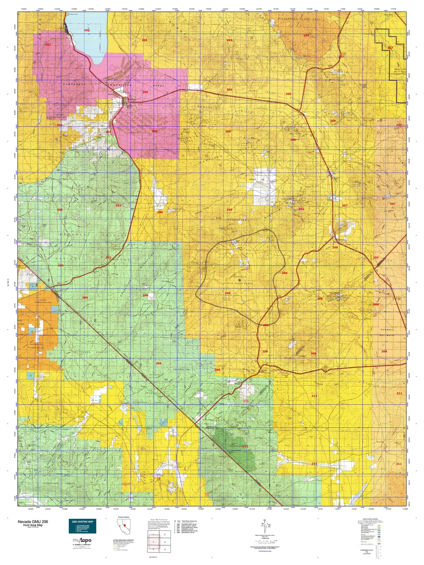
Hunting unit map of Nevada Game Management Unit 206 with topographic lines and unit boundaries. This topo map features UTM / MGRS and Latitude/Longitude grids, plus public land ownership. It comes folded on waterproof paper. Be fully prepared for your hunt with a MyTopo GMU map!.
This map contains the following named places: 89415,89420,89422,93512,Acme,Adobe Creek,Adobe Hills,Adobe Lake,Adobe Ranch,Adobe Reservoir,Alkali Lake,Alum Creek,Antelope Lake,Antelope Mountain,Argentum,Arlemont,Babbitt,Basalt,Basalt Mine and Mill,Belleville,Belleville Tailings Plant,Benton,Big Indian Mountain,Black Beauty Reservoir,Black Dyke Mountain,Black Horse Mining District,Black Lake,Black Mountain,Bley,Borus,Boundary Peak,Boundary Peak Trailhead,Boundary Peak Wilderness,Bramlette Ranch,Brownie Creek,Buena Vista Mining District,Buffalo Point,Buller Mountain,Calmville,Camp Douglas,Candelaria,Candelaria Junction,Candelaria Mines Company Mill,Candelaria Mining District,Candelaria Mountain,Candelaria Pipeline,Candelaria Water Works and Milling Company Mill,Cat Creek,Cat Creek Reservoir,Cedar Hill,Chases,Chiatovich Creek,Chiatovich Ranch,Colonel Youngs Mill,Columbus,Columbus Marsh Mining District,Columbus Mill and Mining Company Mill,Copperfield,Cory Creek,Cory Peak,Coryville,Cottonwood,Cottonwood Creek,Cow Camp,Cowtrack Mountain,Davis,Davis Creek,Dexter Creek,Dover Siding,Dry Creek,Dry Fork,Dutch Creek,Eddyville,Endowment Mill,Excelsior Mountain,Faringtons Salt Dump,Federal Mining and Engineering Company Mill,Finger Rock Station,Fish Lake Valley Mining District,Fitting Mining District,Fletcher Camp,Foreys Toll House,Garfield,Garfield Creek,Garfield Mill,Garfield Mining District,Gates Mill,Gold Hit,Goodwins Borax Works,Granite Mountain,Granite Mountain Wilderness,Hawthorne,Hawthorne Division,Hawthorne Mining District,Hawthorne Speedway,Hawthorne Township,Hereford Valley Ranch,House Creek,Howland Pulverizer,Huntoon Creek,Hutchinson Creek,Indian Head Peak,Indian Queen Quartz Mill,Indian Ranch,Jacks Creek,Jaggersville,Kennedy Point,Kincaid Reservoir,Kinkaid,Kinkead Mill,Kuhlee Ranch,La Panta,Lady Bird Park,Little Squaw Creek,Llama Mountain,London Silver Lead Mines Company Mill,Lucky Boy,Lucky Boy Holding Corral,Lucky Boy Ranch,Luning,Luning Station,Mable Mountain,Malapie Hill,Marietta,Mark Twain Camp,Martinez Hill,McGee Creek,McGeer,McNamara Lake,Metallic City,Middle Creek,Middle Fork Cat Creek,Miller Mountain,Mina,Mina Division,Mina Township,Mineral County,Moho,Moho Mountain,Montgomery City,Montgomery Peak,Morris Creek,Mount Diablo Reduction Works,Mount Ferguson,Mount Grant,Mount Grant Mining District,Mount Hicks,Mount Montgomery,Mountain Queen Mill,Mounts Place,Muller Mountain,Mustang Point,New Boston,New Boston Mill,New York Station,Nichols,North Canyon Creek,North Fork Cat Creek,Northern Belle Companys Lower Mill,Northern Belle Companys Upper Mill,Omco Wash,Oneota,Oro City,Pamlico,Pedro Ranch,Pilot Peak,Pinchot Creek,Pinto Hill,Pinyon Hill,Pizona,Pizona Creek,Powell Creek,Powell Mountain,Qualeys Camp,Queen,Rattlesnake Garfield Drift Fence,Rawhide Ranch,Raydel,Redlich,Rhodes,Rhodes Marsh Mining District,Rhodes Marsh Station,Rhodes Salt Marsh,River Spring Lakes,River Spring Ranch,Rock Creek,Rose Creek,Rose Creek Reservoir,Rutty Mill,Sagehen Peak,Santa Fe Mining District,Schweer Housing Area,Seases Ranch,Silex,Silver Star Mining District,Smith and Companys Borax Mill,Smith Borax Reduction Works,Sodaville,South Fork Cat Creek,Spring Peak,Squaw Creek,Sugarloaf,Sullivans Camp,Sulphide Mining District,Summit,Summit Spring Drift Fence,Summit Station Holding Corral,Sweetapple and Hazeltines Mill,Sweetwater Ranch Company Whisky Flat Unit,Symons Ranch,Table Mountain,Taylor Canyon Camping Area,Teels Marsh,Teels Marsh Mining District,The Crossing,The Jumpoff,Thorne,Thunder Mountain,Tonopah Junction,Trafton Mountain,Trail Creek,Turners Borax Works,Virginia,Volcano Peak,Walker Lake,Walker Lake Boat Harbor,Walker Lake State Park,West Rattlesnake Drift Fence,Wet Fork,Whiskey Flat Holding Corral,Whiskey Flat Reservoir,Whiskey Spring,Whisky Flat Mining District,Willow Creek,Win Wan Flat


