MyTopo
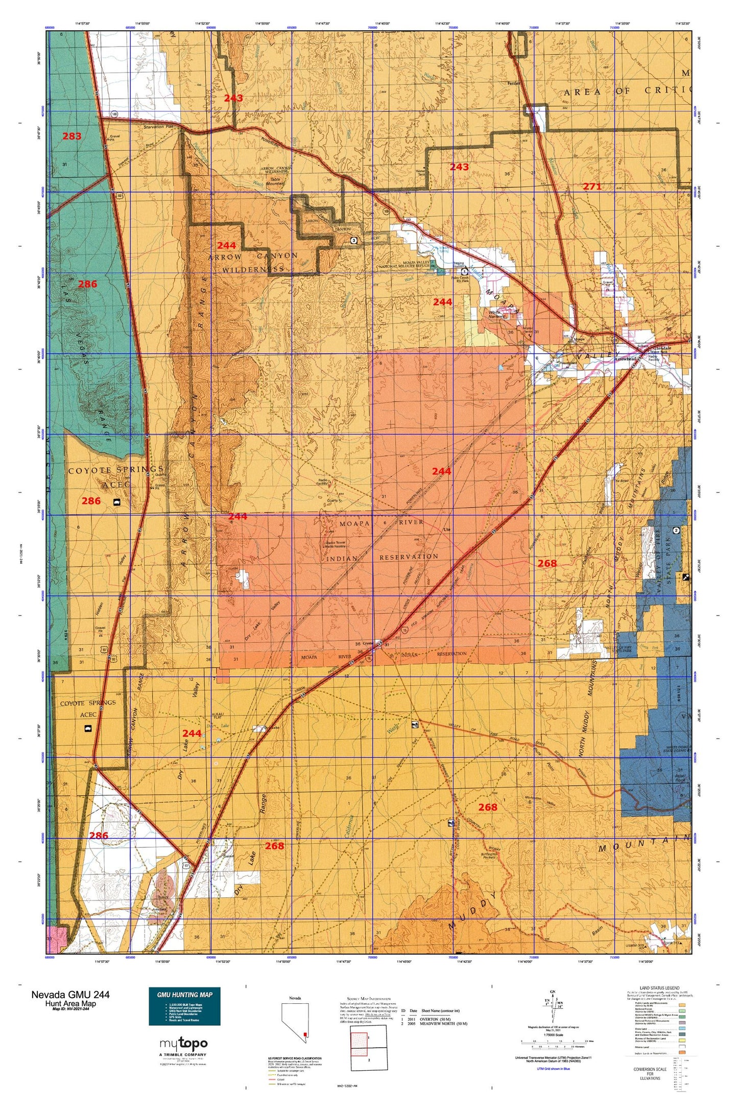
Nevada GMU 244 Map
Couldn't load pickup availability
Hunting unit map of Nevada Game Management Unit 244 with topographic lines and unit boundaries. This topo map features UTM / MGRS and Latitude/Longitude grids, plus public land ownership. It comes folded on waterproof paper. Be fully prepared for your hunt with a MyTopo GMU map!.
This map contains the following named places: 89025,Acton,Arrow Canyon,Arrow Canyon Range,Arrow Canyon Wilderness,Arrowhead,Battleship Wash,Buffington Pockets,Buffington Reservoir,Byron,California Ridge,California Wash,California Wash Reservoir,Cane Springs,CCC Camp,Clarence Lewis Well,Clark County Moapa Fire Station 72,Comstock,Coyote Spring Valley,Crystal,Crystal Springs,Dead Man Hill,Dead Man Wash,Double Canyon,Dry Lake,Dry Lake Post Office,Dry Lake Range,Dry Lake Valley,Farrier,Farrier Wash,Gap Pocket Reservoir,Garnet,Glendale,Glendale Station,Godfrey Ranch,Grapevine Springs,Hidden Valley,Hidden Wash,High Springs,Hogan Spring,Home Ranch,Hupton,Hupton Post Office,Irene Benn Medical Center,KVEG-AM (North Las Vegas),Livingston Number One Spring,Livingston Number Two Spring,McKay Wash,Meadow Valley Wash,Moapa,Moapa Post Office,Moapa Recreation Center,Moapa Recreation Center Park,Moapa River Indian Reservation,Moapa Town,Moapa Town Census Designated Place,Moapa Valley National Wildlife Refuge,Monocline Valley,Muddy Mountains,Muddy River,Muddy Spring,Muddy Wash,Nevada Highway Patrol Southern Command Moapa,North Muddy Mountains,Old California Crossing,Pahranagat Wash,Perkins Number One Reservoir,Perkins Number Two Reservoir,Peterson Spring,Piute Point,Powers Ranch,Searles Ranch,Side Canyon,Side Canyon Wash,Starvation Flat,Table Mountain,The Bowl,Tiffany Quarry,Ute,Ute Perkins Elementary School,Warm Springs,Weiser Ridge,West Point,West Point Post Office,Westpoint Cemetery,White Narrows,White Star Mine,White Star Plaster Mill,Whitmore Wash,Wildcat Wash,Woodruff and Perkins Well,Wyatt Silica Mine