MyTopo
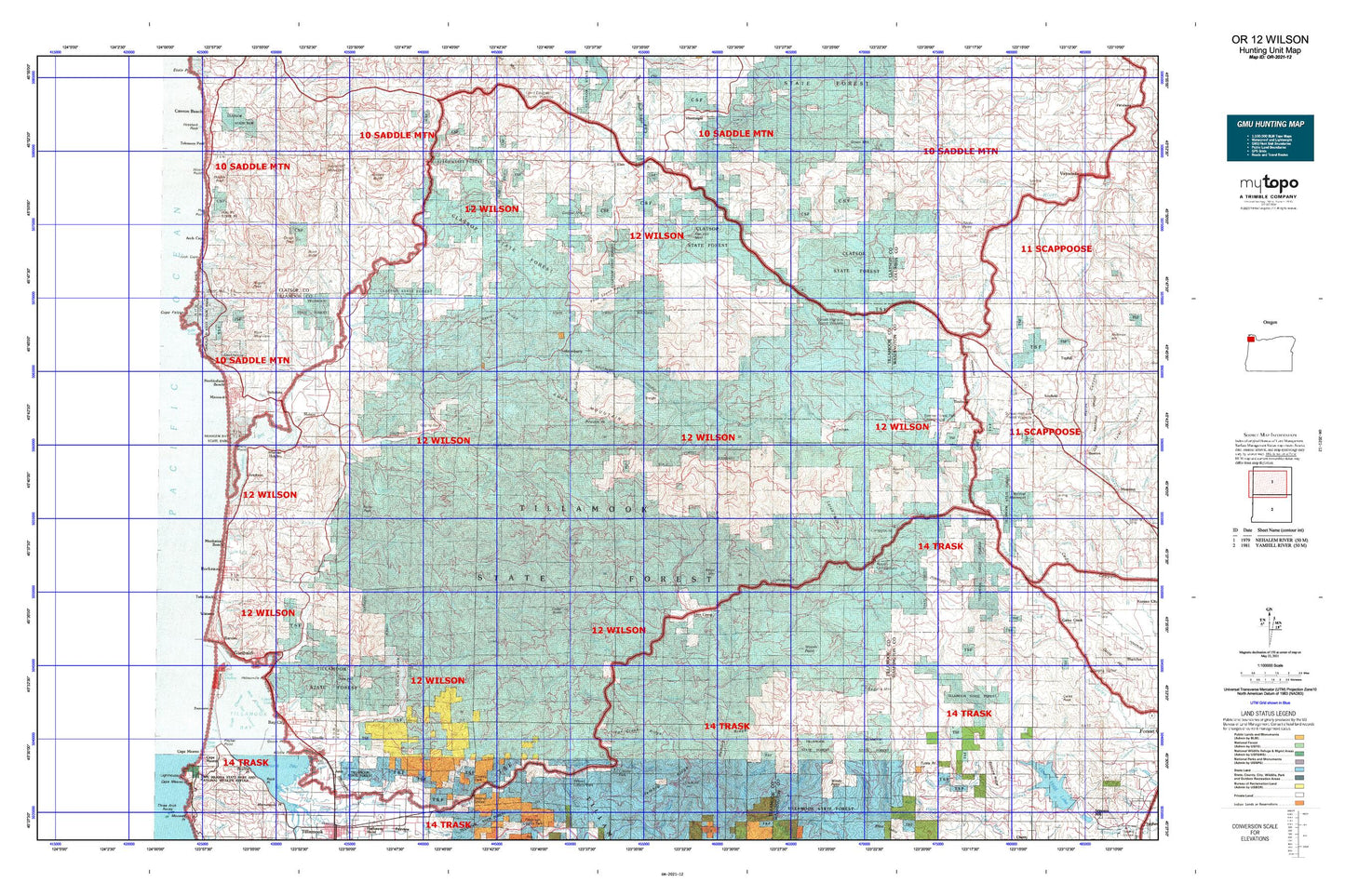
Oregon GMU 12 Wilson Map
Couldn't load pickup availability
Hunting unit map of Oregon Game Management Unit 12 with topographic lines and unit boundaries. This topo map features UTM / MGRS and Latitude/Longitude grids, plus public land ownership. It comes folded on waterproof paper. Be fully prepared for your hunt with a MyTopo GMU map!.
This map contains the following named places: Adair,Akron,Aldervale,Aldervale Boat Launch,Anglersvale,Angora Peak,Arch Cape,Arch Cape Water and Sanitary District,Archer Pond,Armstead Memorial,Asay Dairy,Averill Dairy,Badger,Barnegat,Barnesdale,Barview,Batterson,Bay City,Bay City Reservoir,Bay City Sewage Treatment Plant,Bayocean,Bayside Gardens,Belding,Belding Point,Belfort,Big Baldwin,Black Butte,Bloom Lake,Blue Lake,Blue Lake Guard Station,Blue Lake Logging Company,Blue Lake Lookout,Brighton,Browns Camp OHV Staging Area,Buck Mountain,Buick,Camp Magruder,Camp McGregor,Camp Nehalem,Camp Olson,Cape Meares,Cape Meares County Boat Launch,Cape Meares Lake,Castor Creek,Cedar Butte,Clear Lake,Coal Creek Reservoir,Cochran,Cochran Pond,Cole Mountain,Consolidated Timber Company Camp,Cougar Mountain,County Line,Coyote Corner,Crag Mountain,Creekside,Crescent Lake,Demoley Wilson County Park,Diamond Hill,Dila Dairy,Dog Thief Point,Doty Hill,Double Peak,Douty,East Portland Lumber Company,Eastman,Edwards,Electric Creek Reservoir,Elmore Park,Elsie,Enright,Fern Rock Rest Area,Fernwood,Fishers,Flat Iron Mountain,Foley,Foley Peak,Foss,Gales Creek Campground,Garibaldi,Garibaldi Marina Boat Launch,Garibaldi Old Mill Marina Resort Boat Launch,Garibaldi Sewage Treatment Plant,Glenora,Green Hill,Haak Logging Company,Haddon,Hall Street,Hamlet,Hammond Tillamook Lumber Company,Helloff,Hidden Lake,High Butte,Hillburn,Hobsonville,Howard Rierson Spruce Run County Park,Idaville,Idiotville,Jetty,Jetty Fishery Marina Boat Launch,Jewell Junction,Jordan Creek,Juno,Keasey,Keenig Campground,Kelches River Ry Crossing,Kidders Butte,Kilchis River County Park,Kilchis River Park County Drift Boat Launch,Kilchis Valley Dairy,Killen,Kincheloe Point Boat Access,Kings Mountain,Knudson,L H Timber Company,Lake Lyle County Boat Launch,Lake Lytle,Lake Marie,Larch Mountain,Lees Camp,Logspur,Lost Lake,Lukarilla,Lynbrook,Manhattan Beach,Manzanita,Manzanita Fire Station Park and Ride,Manzanita Water Treatment Plant,Mapes Creek County Drift Boat Launch,Maples,Mayo,McAboy,McNamers Camp,Miami,Ming Point,Mishawaka,Mohler,Mohler Sand and Gravel Boat Launch,Mutt Peak,Neahkahnie,Neahkahnie Beach,Neahkahnie Lake,Neahkahnie Mountain,Nedonna Beach,Nedonna Lake,Nehalem,Nehalem Bay County Boat Launch,Nehalem Bay State Park Boat Ramp,Nehalem Bay Wastewater Agency,Nehalem Falls,Nehalem Fish Hatchery,Nehalem Fish Hatchery Boat Ramp,Nehalem H Street Public Dock,Nehalem Junction,Nehalem River,Nehalem Tohls Street Public Dock,Ocean Lake Park,Oceanlake,Onion Peak,Oswald West State Park,Paquet,Paradise Cove Resort and Marina Boat Ramp,Parks Landing County Boat Launch,Pinochle Peak,Port of Bay City Boat Moorage,Preston,Pye Slough,Randall Hill,Rector,Red Rock Hill,Reeher CCC Camp,Reehers Camp,Reliance,Ripple,River End Dairy,Rock Creek,Rock Mountain,Rockaway Beach,Rockaway Beach Wastewater Treatment Plant,Rogers Forest Park,Rogers Peak,Round Mountain,Round Top,Roy Creek County Park Boat Launch,Ryan Creek Reservoir,Salmonberry,Salmonberry Guard Station,Salmonberry River,Saltair,Seaview,Seaview Lake,Slide Point,Smith Lake,Snark,Soapstone Lake,South Fork Camp,South Fork Timber Company,South Saddle Mountain,South Sugarloaf,Spring Lake,Spruce Run Lake,Stanley Peak,Sterling Forest Station,Stonehill,Struby Creek Reservoir,Sugarloaf Mountain,Sunset Camp,Sunset Safety Rest Area,Timber,Timber Substation,Timbuktu,Tolovana Park,Triangulation Point,Turning Point Dairy,Tuttle Point,Twin Rocks,Twin Rocks Sanitary District,Upper Nehalem,Wakefield,Water Tank,Watseco,Wedeburg,Weist,Westimber,Wheeler,Wheeler Heights,Wheeler Lumber Company,Wheeler Public Boat Ramp,Wheeler Siding,Wilson,Wilson River Picnic Ground,Wilson River Safety Rest Area,Windy Point,Wolf Point,Woods Point


