MyTopo
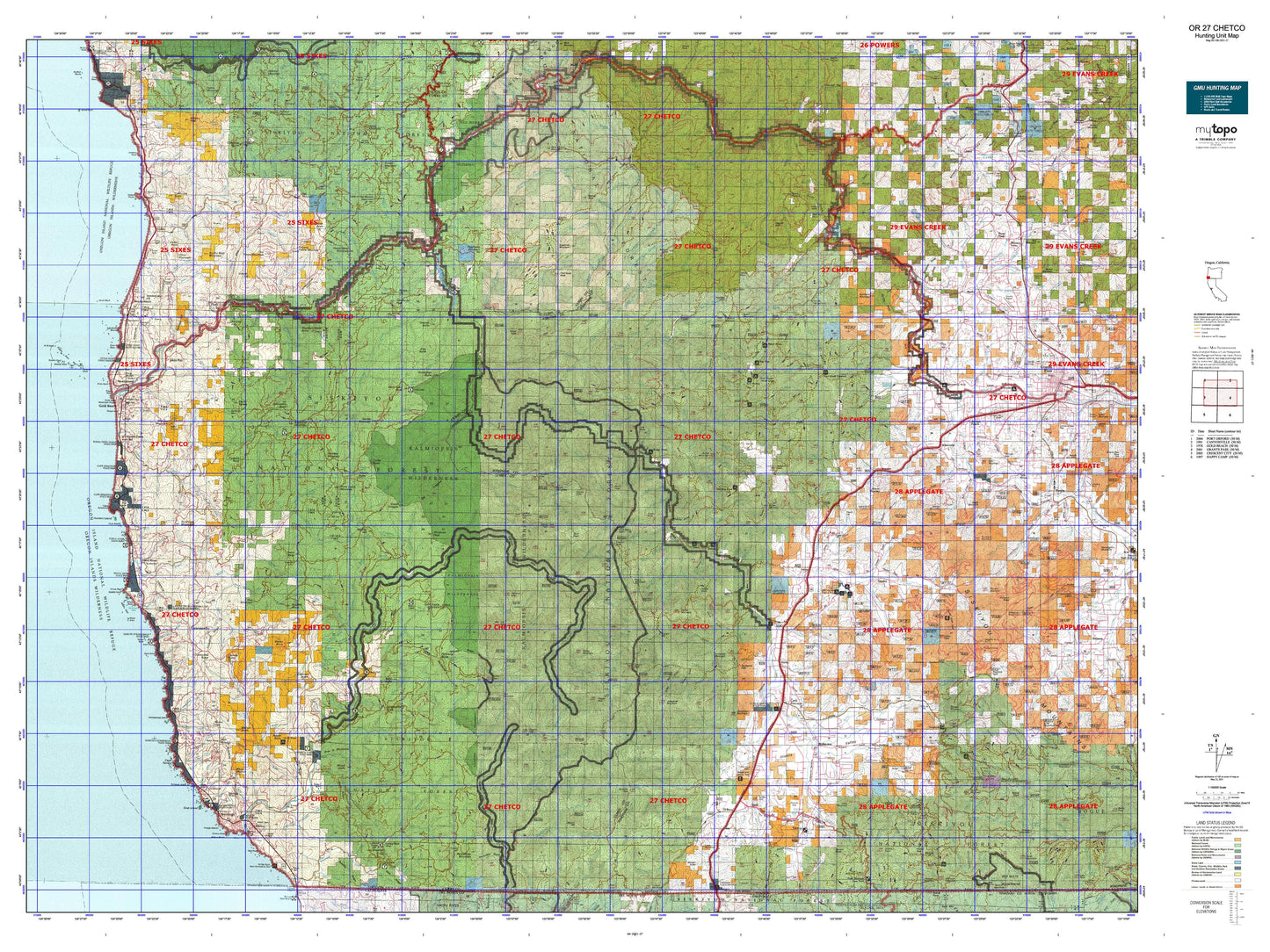
Oregon GMU 27 Chetco Map
Couldn't load pickup availability
Hunting unit map of Oregon Game Management Unit 27 with topographic lines and unit boundaries. This topo map features UTM / MGRS and Latitude/Longitude grids, plus public land ownership. It comes folded on waterproof paper. Be fully prepared for your hunt with a MyTopo GMU map!.
This map contains the following named places: Agness,Allen Pool,Allentown,Althouse,Apple Rogue Reservoir,Babyfoot Lake,Bagnell Ferry,Bailey Mountain,Bald Mountain,Baldface Lake,Basin Butte,Big Craggies,Big Eddy,Bigelow Lakes,Biscuit Hill,Black Mound,Bobs Garden Mountain,Bolan Lake,Bolan Lake Dam,Bolan Mountain,Bolt Mountain,Bosley Butte,Brandy Peak,Bridgeview,Brookings,Browntown,Brushy Bald Mountain,Brushy Mountain,Buck Peak,Buckhorn Mountain,Buckskin Peak,Bush Mound,Buzzard Roost,Buzzards Roost,California Bar,Canfield Hill,Canyon Peak,Carpenterville,Cashner Butte,Cassiday Butte,Cave Junction,Cedar Mountain,Cedar Point,Chetco Lake,Chetco Peak,Chinaman Hat,Chismore Butte,Coffee Butte,Colebrook Butte,Colegrove Butte,Collier Butte,Dads Lake,Daily Reservoir,Devils Half Acre,Dry Butte,Dryden,Eagle Mountain,Eight Dollar Mountain,Elder Mountain,Elk Mountain,Esterly Lakes,Euchre Creek Pond,Fairview Mountain,Fall Mountain,Ferguson Pond,Fiddler Mountain,First Prairie Mountain,Fish Hook Peak,Flat Top,Foster Pond,Freeland Mountain,French Peak,Galice,Game Lake,Gilligan Butte,Gold Basin Butte,Gold Beach,Granite Butte,Grass Lake,Green Craggie,Green Hill,Green Knob,Grizzly Mountain,Grizzly Peak,Harbor,Harris Butte,Hawks Rest,Hayes Hill,Hayward Peak,Heather Mountain,Hobson Horn,Hog Mountain,Holcomb Peak,Holland,Horse Mountain,Horse Sign Butte,Hubbard Mound,Hugo,Hungry Hill,Hunter Creek,Illahe,Indian Hill,Indian Rock,Jacoby Butte,Jerrys Flat,Johnson Butte,Johnson Point,Josephine Mountain,Kennison Reservoir,Kerby,Kerby Peak,Kimball Hill,Klose Pond,Knoxville,Lake of the Woods,Lake of the Woods Mountain,Lawson Butte,Leland,Libby Creek Pond,Lish Lake,Little Grayback Peak,Little Silver Creek Lake,Little Vulcan Lake,Lobster Hill,Lone Mountain,Maloney Peak,Marble Mountain,Mary K Reservoir,Merlin,Mineral Hill,Mislatnah Peak,Mooney Mountain,Morgans Buckhorn,Morton Butte,Mount Billingslea,Mount Emily,Mount Hope,Mount Italy,Mount Peavine,Mungers Butte,Murphy Mountain,Nesika Beach,Nome Peak,Number Eight Peak,O'Brien,Onion Mountain,Ophir,Ophir Mountain,Oregon Coast Log Pond,Our Mountain,Packsaddle Mountain,Page Mountain,Palmer Butte,Panther Lake,Panther Mountain,Pearsoll Peak,Pebble Hill,Peggler Butte,Pine Point,Pistol River,Pistol River Log Pond,Pleasant Valley,Pocket Knoll,Pollywog Butte,Potato Illahe Mountain,Princess Peak,Quail Prairie Mountain,Quosatana Butte,Rabbit Lake,Racetrack Hill,Rand,Raspberry Mountain,Red Mound,Red Mountain,Red Rock,Redwood,Ridge Knob,Rocky Peak,Rosenberg Reservoir,Rough and Ready Lakes,Rough and Ready Log Pond,Rough and Ready Mill Pond Dam,Roundtop Mountain,Rumley Hill,Saddle Mountain,Salamander Lake,Sand Hill,Second Prairie Mountain,Selma,Serpentine Point,Sevenmile Peak,Signal Buttes,Silver Peak,Skookumhouse Butte,Sloan Mountain,Smith Hill,Smith Hole,Snaketooth Butte,Snow Camp Mountain,Soldier Camp Mountain,South Bend Mountain,South Coast Log Pond,Southard Lake,Squaw Mountain,Squirrel Peak,Stack Yards,Steppe Reservoir,Sugarloaf,Sugarloaf Mountain,Sundown Mountain,Takilma,Tall Timber Reservoir,Taylor Mountain,Tennessee Mountain,Thomas Hill,Three Pines,Three Trees,Tincup Peak,Tomcat Hill,Ulmer Mountain,Valen Lake,Vondergreen Hill,Vulcan Lake,Vulcan Peak,Waldo Hill,Wedderburn,Wee Bonnie Loch Glen Reservoir,Werner Reservoir,Whetstone Butte,Whiskers Peak,Wilderville,Wonder,Wonder Mountain,Woodcock Mountain,York Butte