MyTopo
Oregon GMU 45 Fossil Map
Couldn't load pickup availability
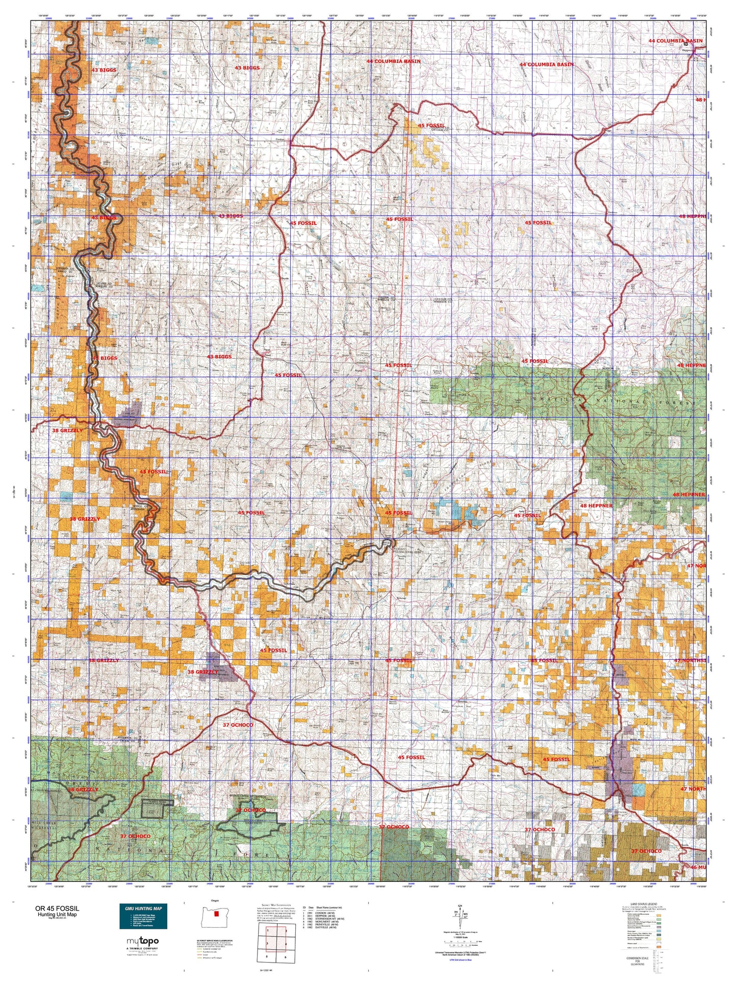
Hunting unit map of Oregon Game Management Unit 45 with topographic lines and unit boundaries. This topo map features UTM / MGRS and Latitude/Longitude grids, plus public land ownership. It comes folded on waterproof paper. Be fully prepared for your hunt with a MyTopo GMU map!.
This map contains the following named places: Alder Mountain,Alville,Amine Peak,Aspen Reservoir,Bailey Butte,Bald Mountain,Baldy,Bandit Spring Safety Rest Area,Beaver Forest Service Station,Black Butte,Black Rock,Black Top,Blann Meadow Reservoir,Brandenburg Reservoir,Bridge Creek,Bruce Reservoir,Buckhorn Ranch,Bull Prairie Guard Station,Bull Prairie Lake,Bulls Eye Butte,Burnt Ranch,Burton Hill,Butler Mountain,Byrds Point,Caleb,Camas Butte,Camas Prairie,Camel Hump,Camp Hancock,Chapin Guard Station,Cherry Creek Ranch,China Hat Peak,City Farm,Clark Lake,Clarno,Coffin Rock,Collins Butte,Collins Reservoir,Condon,Condon Reservoir,Cone Mill,Corncob Ranch,Corral Mountain,Cougar Butte,Courthouse Rock,Coyote Butte,Coyote Mountain,Crosswhite Butte,Crown Rock,Currant Peak,Dollarhide Pond,Dove Mountain,Dry Lake,Edwards,Eightmile,Fairview Recreation Site,Fitzgerald Ranch,Flock Mountain,Fopiano Ranch,Fopiano Reservoir,Fort Creek Reservoir,Fossil,Frizzel Mountain,Gage Ranch,Ghost Camp,Gilchrist Butte,Gooseberry,Grade,Grassy Butte,Gwendolen,H Johnson Ranch,Hardman,Harper Mountain,Hay Creek Butte,Heidtmann Mountain,Hoogie Doogie Mountain,Hoover Creek Reservoir,Horse Mountain,Howard Ranch,Hubbel Lake,Hudspeth Mill,Humphrey Ranch,Igo,Igo Butte,Ihrig Ranch,Indian Camp,Indian Mountain,Indian Rocks,Iron Mountain,Jennies Peak,Jones Ranch,Juniper Butte,Kentucky Butte,Keyes Mountain,Keys Mountain,Keys Reservoir,Kimberly,Kinzua,Kinzua Golf Course,Kinzua Mountain,Kinzua Reservoir,Knox Ranch,Kotzman Butte,Lawson Mountain,Lewis Butte,Lewis Rock,Little Round Butte,Little Tamarack Mountain,Lone Pine Butte,Lone Reservoir,Lonerock,Long Prairie Reservoir,Lost Valley,Ludwick Cabin,Mabe Hill,Mahogany Butte,Marshall Butte,Mascall Ranch,Masiker Mountain,Maxwell Reservoir,Mayville,Middle Mountain,Mitchell,Mitchell Guard Station,Mitchell Mountain,Monroe Roughs,Mossy Rock Camp,Mount Misery,Muddy Ranch,Muddy Reservoir,Muleshoe Mountain,Murtha Ranch,Negro Knob,Nelson Butte,Nelson Place,Nelson Reservoir,Ochoco Divide Recreation Site,Old Armunger Cabin,Old Buckhorn Ranch,Old Frizzell Ranch,Old Johnson Cabin,Old Kelly Mill,Old Stephenson Ranch,Old Watkins Cabin,Opal Butte,Packsaddle Mountain,Painted Hills,Painted Hills Reservoir,Payne Ranch,Paynes Pond,Peggy Butte,Petersons Ponds,Porcupine Butte,Prairie Ranch,Prindle Peak,Rainbow Hill,Rancheria Rock,Rattlesnake Butte,Rattray Ranch,Red Hill,Red Rock,Red Scar Knoll,Reeds Mill,Rettie Butte,Richard Butte,Richmond,Rills Pond,Rock Fort,Rood Hill,Rowe Creek Reservoir,Ruggs,Sand Mountain,Sand Spring Butte,Sandrock Mountain,Sargent Butte,School Section Cabin,Scott Butte,Sentinel Peak,Service Creek,Sheep Mountain,Shingle Mill Butte,Shoofly Ranch,Simpson Place,Sixshooter Ranch,Smith Ranch,Snowshoe Point,Spoos Mill,Spray,Squaw Butte,Stalling Butte,Steamboat Mountain,Steiwer Peaks,Stephenson Lake,Stephenson Mountain,Stewarts,Stuckey Butte,Stuckey Butte Reservoir,Sugarloaf Mountain,Sutton Ranch,Table Mountain,Table Rock,Tamarack Mountain,Taylor Ranch,Thirtymile,Thompson Butte,Tittie Butte,Toney Butte,Tracy Mountain,Trail Fork,Tri-Creek Ranch,Twickenham,Twin Buttes,Upper Cherry Creek Ranch,Valby,View Point,Wagner Mountain,Wagner Ranch,Waldron,Waterman,Wetmore,Wheeler County Fairgrounds,Wheeler Point,Whistle Point,Whistler Point,Whistler Recreation Site,White Butte,Whitecap Knoll,Whitetail Butte,Wild Horse Butte,Windy Point,Wineland Lake,Winlock,Woodward Ranch,Zero Butte,Zinter Pond