MyTopo
Oregon GMU 50 Desolation Map
Couldn't load pickup availability
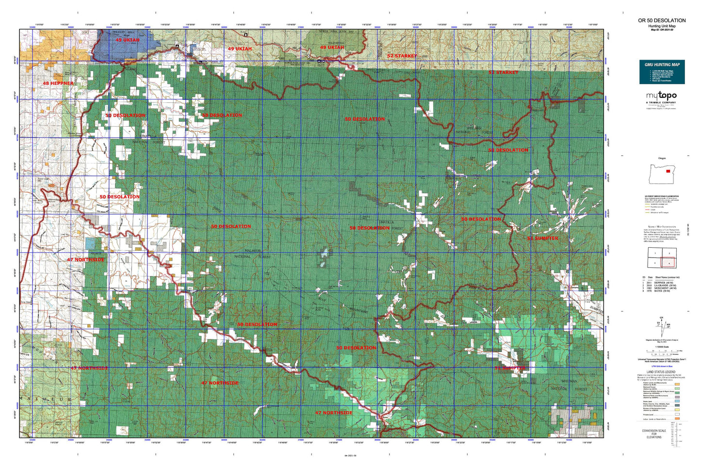
Hunting unit map of Oregon Game Management Unit 50 with topographic lines and unit boundaries. This topo map features UTM / MGRS and Latitude/Longitude grids, plus public land ownership. It comes folded on waterproof paper. Be fully prepared for your hunt with a MyTopo GMU map!.
This map contains the following named places: Alamo,Armstrong Creek,Austin,Backout Creek,Badger Butte,Badger Creek,Balance Creek,Balance Lake,Baldy Creek,Baldy Lake,Barnes Creek,Basin Camp,Basin Creek,Battle Creek,Battle Creek Camp,Battle Creek Guard Station,Beagle Creek,Bear Camp,Bear Creek,Beaver Creek,Beaver Meadows,Beeman Creek,Ben Camp,Ben Harrison Peak,Bennett Creek,Big Boulder Creek,Big Creek,Big Meadow Camp,Big Rock,Bismark Creek,Black Butte,Blackeye Creek,Bone Point,Boulder Butte,Boulder Creek,Boundary Creek,Boundary Creek Forest Service Station,Bruin Creek,Brush Creek,Buck Creek,Bull Creek,Bull Run Creek,Bullrun Creek,Bully Creek,Butte Creek,Cabell City,Camp Creek,Camp Simms,Caribou Creek,Carroll,Case Place,Channel Creek,Chattanooga Mountain,China Creek,City of Granite,City of Greenhorn,Clear Creek,Clifford,Cold Spring Camp,Corral Camp,Corral Creek,Corrigal Spring Campground,Cottonwood Creek,Cougar Creek,Coyote Creek,Crane Creek,Crane Flats Forest Service Station,Crawfish Creek,Cress Creek,Crockett Knob,Crockett Knob Lookout,Cub Creek,Dairy Creek,Davis Creek,Deadwood Creek,Deep Creek,Deerhorn Campground,Deerhorn Creek,Desolation Butte,Desolation Butte Lookout,Desolation Guard Station,Ditch Creek,Donaldson Rock,Dry Creek,Dunston Creek,East Fork Big Creek,East Fork Boundary Creek,East Fork Clear Creek,East Fork Coyote Creek,East Fork Meadow Brook,East Fork Sunshine Creek,East Ten Cent Creek,Elk Creek,Elliot Creek,Flat Camp,Flat Creek,Fly Creek,Forty Day Creek,Fox Camp,French Diggings,Galena,Geiser,Geiser Creek,George Hinton Ranch,Gibbs Creek,Gilson Creek,Gilson Pond,Gimlet,Glade Creek,Gold Center,Gorge Creek,Granite,Granite Boulder Creek,Granite Creek,Greenhorn,Greenhorn Creek,Gutridge Creek,Hale Ranch,Hawkins Creek,Head O'Boulder Camp,Headquarters Camp,Hi Yu Guard Station,Hog Creek,Hoodoo Creek,Horse Creek,Howard Creek,Howard Meadow Camp,Huckleberry Butte,Huckleberry Camp,Huckleberry Creek,Indian Creek,Indian Rock,Ingram Creek,Jackknife Creek,Jonas Creek,Jonas Mountain,Jordan Creek,Jugow Creek,Jumpoff Joe Camp,Jumpoff Joe Lake,Jumpoff Joe Peak,Jungle Creek,Junkens Creek,Kahler Butte,Keeney Camp,Keeney Creek,Keeney Point,Kelsay Butte,Kelsay Creek,Knapp Ranch,Lake Creek,Lamb Creek,Last Chance Creek,Lawton,LC Mountain Translator Site,Lemon Cabin,Lemon Creek,Lick Creek,Lightning Creek,Line Creek,Little Boulder Creek,Little Butte Creek,Log Table Camp,Lon Krise Cabin,Long Creek Mountain,Lost Camp,Lost Creek Camp,Lost Lake,Lower Camp Creek Recreation Site,Lower Cougar Camp,Lower End Camp,Lower Howard Camp,Meadow Camp,Middle Fork John Day River Rest Area,Middle Fork Recreation Site,Miners Cabin,Mount Ireland,Mutton Camp,Myrtle Butte,North Fork John Day Recreation Site,North Fork John Day Wild and Scenic River,North Fork John Day Wilderness,Olive Butte,Olive Lake,Olive Lake Boat Launch,Olive Lake Camp,Olive Lake Recreation Site,Oregon Gulch Camp,Oriental Creek Recreation Site,O'Rorke Ranch,Parkers,Parkersville,Peep Creek Camp,Porterville,Pothole Camp,Psyche Butte,Putney Mountain,Quebec Hill,Rabbit Butte,Ragged Rocks,Range,Ranger Station Camp,Raspberry Creek,Ritter Butte,Robinsonville,Rock Spring Camp,Rush Pond,Saddle Camp,Sheep Creek,Sheep Rock,Silver Butte,Silver Spring Camp,Sponge Creek Camp,Summit Camp,Sunrise Butte,Susanville,Swamp Creek,Telephone Spring Camp,Ten Cent Butte,The Cockscomb,Tipton,Trout Meadows Butte,Twin Buttes,Twin Ponds,Upper Cougar Camp,Upper Howard Camp,Vinegar Hill,Vinegar Hill-Indian Rock Scenic Area,Welch Creek Recreation Site,West Fork Boundary Creek,Whisky Creek,White Pine,Wildcat Point,Willow Creek Butte,Windy Point