MyTopo
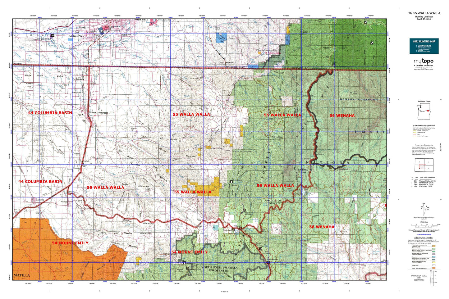
Oregon GMU 55 Walla Walla Map
Couldn't load pickup availability
Hunting unit map of Oregon Game Management Unit 55 with topographic lines and unit boundaries. This topo map features UTM / MGRS and Latitude/Longitude grids, plus public land ownership. It comes folded on waterproof paper. Be fully prepared for your hunt with a MyTopo GMU map!.
This map contains the following named places: 97862,97886,Athena,Athena City Park,Athena Memorial Ball Park,Athena Wastewater Treatment Plant,Bade,Baker-Langdon,Bald Mountain,Bar M Ranch,Barrett,Barrett Field Airport,Basket Mountain,Bates,Bear Creek,Bear Creek Guard Station,Bear Trap Canyon,Bear Trap Spring,Big Meadow Canyon,Big Meadows,Big Rayborn Canyon,Big Saddle,Big Saddle Canyon,Big Sink,Big Spring Branch,Bingham Springs,Birch Creek,Blalock Mountain,Blue Mountain,Blue Mountain Camp,Blue Mountain Lutheran Bible Camp,Bone Spring,Bone Spring Campground,Boulder Ridge,Bowlus Canyon,Bowlus Cemetery,Bowlus Ditch,Bowlus Hill,Box Canyon,Broken Creek,Broken Ridge,Buckskin Spring,Burnt Cabin Gulch,Calhounville,Cash Hollow,City of Athena,City of Milton-Freewater,City of Weston,Cobb,Cold Spring,Columbia Heights,Couse Creek,Coyote Canyon,Coyote Ridge,Crockett,Cub Spring,Cup Gulch,Davis Orchards,Deadman Gulch,Deadman Spring,Deduct Forest Camp,Deduct Spring,Demaris Cabin,Dick Spring,Dorothy Ditch,Downing,Dry Hollow,Dugger Creek,Duggor Park,Dusty Ridge,Dusty Spring,Dusty Spring Forest Camp,Eagle Creek,East Crockett Branch,East Ford,East Fork Coyote Creek,East Little Walla Walla River,East Prong Little Walla Walla River,Elbow Creek,Elliott Memorial Park,English Spring,Ferndale,Flume Canyon,Ford Branch,Ford Cemetery,Freewater Park,Gabriel Spring,Goodman Spring Branch,Government Mountain,Grandview Creek,Grouse Mountain,Harris Park Recreation Site,Hay Creek,Heifer Creek,Henry Canyon,Hodgson Canyon,Hudson Bay,Hudson Bay Canal,Husky Spring,Hyatt Cemetery,Indian Ridge,Intake Trail,Johns,Johnson Creek,Jubilee Lake,Jubilee Lake Campground Boat Ramp,Jubilee Lake Recreation Site,Jubilee Meadows Dam,Kaseberg Canyon,Kees Canyon,Key Cemetery,King's Airport,Kiwanis Camp,Klicker Mountain,Kooskooskie,La Marr Gulch,Langdon Lake,Langdon Lake Dam,Lick Creek Trail,Lincton Mountain,Little Dry Creek,Little Meadow Canyon,Little Meadows,Little Rayborn Canyon,Little Walla Walla River,Lost Creek,Low Ridge,Low Ridge Creek,Luger Spring,McDougall Camp,McIntyre Lookout,Middle Fork Cottonwood Creek,Middle Mud Creek,Milk Shakes,Mill Creek Watershed,Milton - Freewater Sewage Treatment Plant,Milton Ditch,Milton Hill,Milton Substation,Milton-Freewater,Milton-Freewater Division,Morning Creek,Morning Creek Sno-Park,Mottet Recreation Site,Mottet Spring,Nichols Canyon,North Fork Cottonwood Creek,North Fork Mill Creek,North Fork Trail,North Fork Walla Walla River,Old City Cemetery,Oregon Sky Ranch Airport,Page Airport,Paradise Creek,Paradise Ridge,Peterson Ridge,Pikes Peak,Pine Ridge,Pleasant View Canal,Pole Creek,Poplar Springs Dam,Poplar Springs Reservoir,Prunedale,Pumpkin Hollow,Railroad Canyon,Reed and Hawley Mountain,Reser Cabin,Reser Creek,Reservation Mountain,Rimrock Ridge,Rock Creek,Rodgers Gulch,Rodgers Ridge,Saddle Mountain,Scott Canyon,Sheep Creek,Skiphorton Creek,Skookum Creek,Skyline Recreation Site,South Fork Camp,South Fork Cottonwood Creek,South Fork Walla Walla River,Spence Ditch,Spofford,Spout Springs Ski Area,State Line,Stateline,Stone Creek,Stone Hill Reservoir,Summer Creek,Sunnyside,Swamp Creek,Swamp Creek Corral,Swede Canyon,Table Creek,Table Glade,Tamarack Basin,Tanks,Target Meadows,Target Meadows Campground,The Horseshoe,Tiger Creek,Tollgate,Tollgate Chateau,Tollgate Guard Station,Tollgate Work Camp,Tollgate Work Center,Trail Ridge,Twilight,Tye Canyon,Umapine,Umapine Census Designated Place,Umapine Division,Umatilla Brakes Viewpoint,Valley Chapel Cemetery,W. W. V. Ry. Crossing,Webb Creek,West Branch West Crockett Branch,West Crockett Branch,West Ford,West Fork Coyote Creek,Weston,Weston Cemetery,Weston Division,Weston Mountain,Weston Pond,Weston Station,Weston Wastewater Treatment Plant,Wildhorse Mountain,Woodward Creek,Woodward Recreation Site,Yantis Park,Yellow Jacket Point,Yellowhawk Creek,Zell Ditch


