MyTopo
Oregon GMU 56 Wenaha Map
Couldn't load pickup availability
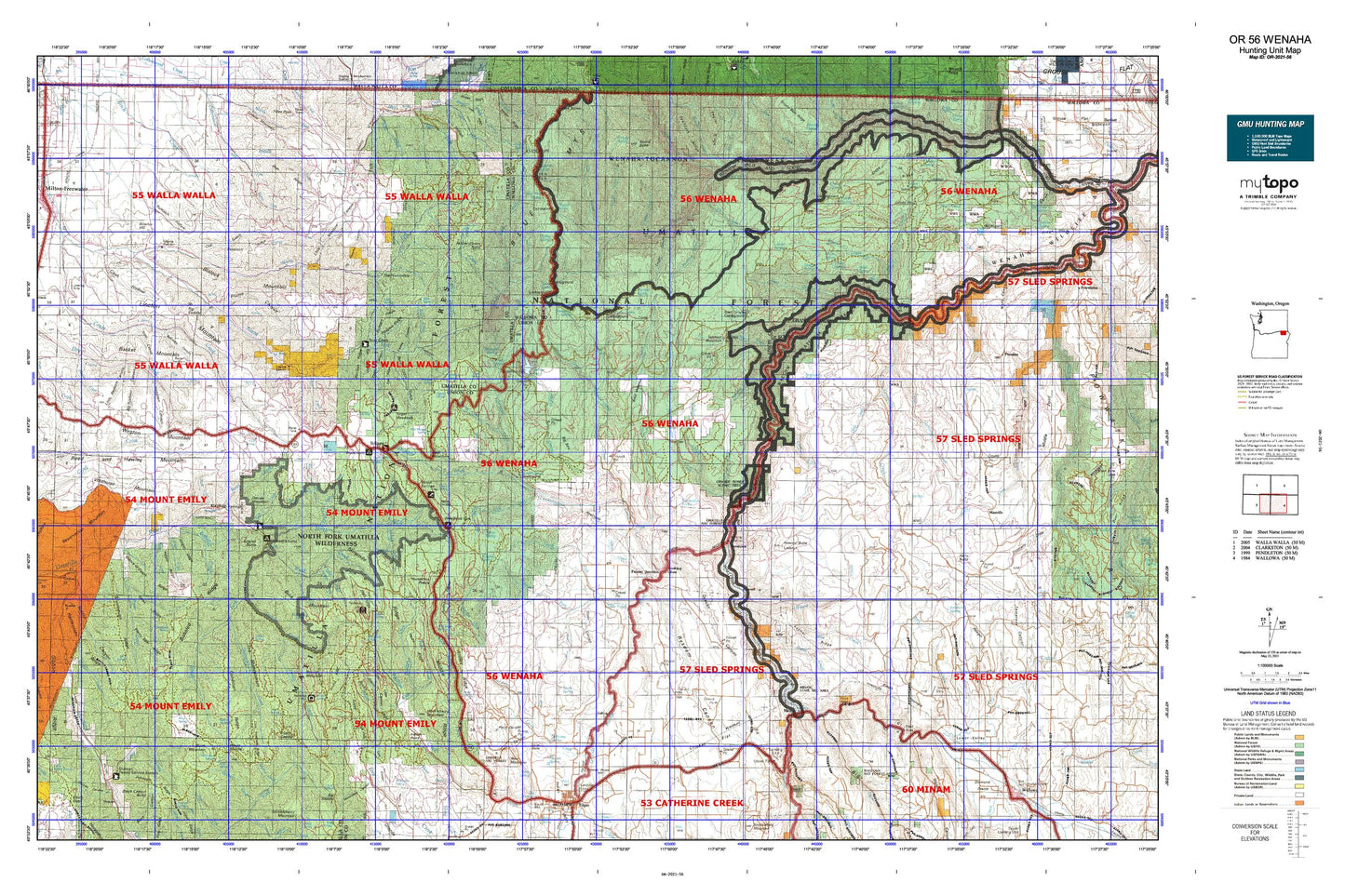
Hunting unit map of Oregon Game Management Unit 56 with topographic lines and unit boundaries. This topo map features UTM / MGRS and Latitude/Longitude grids, plus public land ownership. It comes folded on waterproof paper. Be fully prepared for your hunt with a MyTopo GMU map!.
This map contains the following named places: 97862,97886,Akers Butte,Alder Creek,Andies Ridge,Andys Rapids,Bailey Creek,Bald Mountain,Bar M Ranch,Basket Mountain,Bear Canyon Campground,Bear Creek,Bear Creek Guard Station,Beaver Creek,Big Canyon Fish Weir,Big Canyon Fish Weir Recreation Site,Big Sink,Bingham Springs,Bishop Meadows,Black Mountain,Blalock Mountain,Blue Mountain Camp,Blue Mountain Lutheran Bible Camp,Bobsled Creek,Bobsled Ridge,Bobsled Trail,Bone Spring Campground,Boulder Ridge,Bowlus Ditch,Bowlus Hill,Boyd Creek,Bruce Camp,Buck Creek,Buck Creek Group Camp,Buck Mountain,Buzzard Creek,Cabin Creek,Camp Five,Clear Creek,Coal Docks,Coyote Creek,Coyote Ridge,Craigs Cabin,Cricket Flat,Cross Canyon Trail,Deduct Forest Camp,Deep Creek,Deer Creek,Demaris Cabin,Dorothy Ditch,Dry Creek,Duncan Guard Station,Dusty Ridge,Dusty Spring Forest Camp,Eagle Creek,East Branch Gordon Creek,East Fork Coyote Creek,East Grossman Creek,East Phillips Creek,Elbow Creek,Elgin Division,Elgin Sewer Treatment Plant,Elk Campground,Elk Creek,Elk Flats Recreation Site,Eustis,Finley Creek,Finley Creek Cow Camp,Finley Ridge,Fisher Creek,Forks Ridge,Fry Meadow Creek,Fry Meadow Guard Station,Government Mountain,Grande Ronde Scenic Area,Grande Ronde Wild And Scenic River,Graves Butte,Grossman,Grossman Creek,Grouse Mountain,Gulling,Hagar Creek,Hagen Creek,Harris,Harris Park Recreation Site,Hoodoo Ridge,Howard Butte,Howard Creek,Howardville,Huckleberry Mountain,Indian Point,Jarboe Creek,Jaussaud Corral,Jaussaud Creek,Johnson Creek,Jones Butte,Jubilee Lake,Jubilee Lake Campground Boat Ramp,Jubilee Lake Recreation Site,Jubilee Meadows Dam,Kimmell,Lake Creek,Langdon Lake,Langdon Lake Dam,Lick Creek,Lick Creek Trail,Lincton Mountain,Little Lookingglass Creek,Looking Glass,Lookingglass Creek,Lookingglass Falls,Lookingglass Fish Hatchery,Lookout Mountain,Lost Creek,Lower Valley,McDougall Camp,McIntyre Lookout,Meadow Creek,Medicine Creek,Merritt Reservoir,Middle Fork Cottonwood Creek,Milk Creek,Milton-Freewater Division,Minam,Minam Hill,Minam River,Minam State Park,Minham State Recreation Area Boat Ramp,Morning Creek,Morning Creek Sno-Park,Moses Creek,Mottet Creek,Mottet Recreation Site,North Fork Cabin Creek,North Fork Trail,North Fork Umatilla River,North Fork Umatilla Wilderness,North Fork Walla Walla River,North Fork Wenaha River,Owenby Hill,Palmer Junction,Partridge Creek,Pearson Cabin,Pedro Creek,Peterson Ridge,Pine Creek,Pine Ridge,Pole Creek,Powder House Hill,Proctor Creek,Pyles Canyon Dam Number Two,Reed and Hawley Mountain,Reser Cabin,Reser Creek,Reservation Mountain,Rock Creek,Rocky Bedground,Rondowa,Roulet Pond,Round Mountain,Ruckel Junction,Ryan Creek,Scotts Spur,Sevier,Sheep Creek,Shell Creek,Shimmiehorn Creek,Shoofly Creek,Sickfoot Creek,Skiphorton Creek,Skookum Creek,Skylight Canyon,Skyline Recreation Site,Slick Ear Creek,Sloan,Smith Mountain,South Fork Cabin Creek,South Fork Camp,South Fork Campground,South Fork Cottonwood Creek,South Fork Umatilla River,South Fork Walla Walla River,South Fork Wenaha River,Spence Ditch,Spout Springs Ski Area,Spring Creek,Stanley Cabin,Stone Hill Reservoir,Summer Creek,Swamp Creek,Swamp Creek Corral,Sweikert Ranch,Table Creek,Tamarack Basin,Tanks,Target Meadows Campground,The Horseshoe,The Shimmiehorn,Thomas Creek,Tikem Creek,Tikem Falls,Timothy Spring Campground,Tollgate,Tollgate Chateau,Tollgate Guard Station,Tollgate Work Camp,Tollgate Work Center,Trapper Creek,Umatilla Brakes Viewpoint,Umatilla Forks Recreation Site,Umatilla National Forest,Vincent,Wade,Waller Reservoir 2,Waller Reservoir 3,Waller Reservoir 4,Waller Reservoir 5,Waller Reservoir 6,Wallowa Lake Highway Forest State Park,Wallowa River,Wallowa Wild and Scenic River,Weelikeecet Creek,Wenaha Forks,West Fork Coyote Creek,West Mountain,Weston Division,Weston Mountain,Weston Pond,Wildhorse Mountain,Wise Creek,Woodland Recreation Site,Woodland Sno-Park,Woodward Creek,Woodward Recreation Site,Yellow Jacket Point