MyTopo
Pell City Alabama US Topo Map
Couldn't load pickup availability
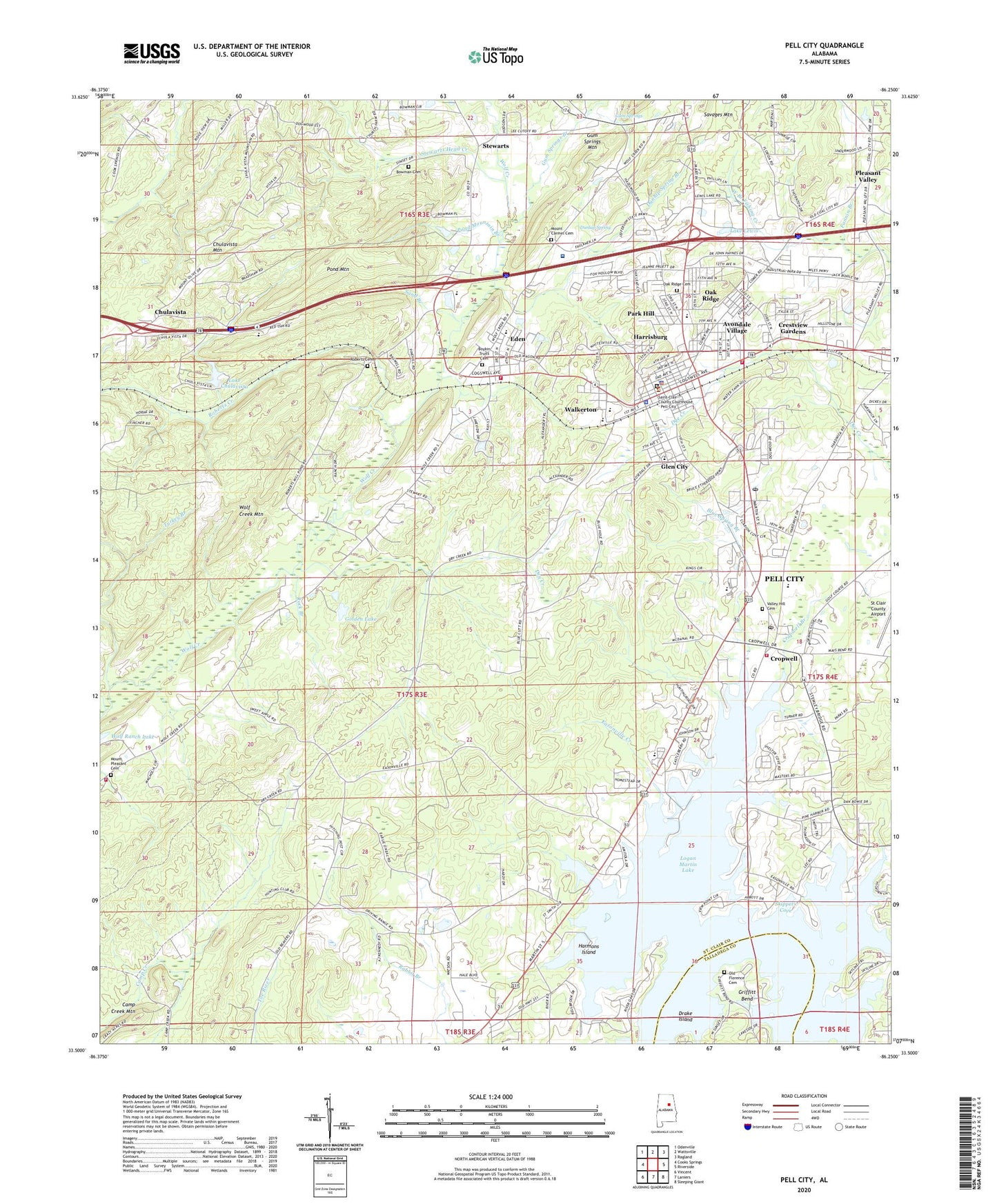
2024 topographic map quadrangle Pell City in the state of Alabama. Scale: 1:24000. Based on the newly updated USGS 7.5' US Topo map series, this map is in the following counties: St. Clair, Talladega. The map contains contour data, water features, and other items you are used to seeing on USGS maps, but also has updated roads and other features. This is the next generation of topographic maps. Printed on high-quality waterproof paper with UV fade-resistant inks.
Quads adjacent to this one:
West: Cooks Springs
Northwest: Odenville
North: Wattsville
Northeast: Ragland
East: Riverside
Southeast: Sleeping Giant
South: Laniers
Southwest: Vincent
This map covers the same area as the classic USGS quad with code o33086e3.
Contains the following named places: Arbor Baptist Church, Avondale Lake, Avondale Village, Bethlehem Baptist Church, Bible Methodist Camp, Bible Methodist Church, Bible Missionary Church, Blue Spring Branch, Bowman Cemetery, Boykin Truitt Cemetery, Camp Creek Mountain, Catatoga Estates, Chulavista, Chulavista Dam, Chulavista Mountain, Church of God in Christ, Church of God of Prophecy, City of Pell City, Comer Avenue Industrial Park, Coosa Valley Baptist Church, Coosa Valley Elementary School, Crestview Gardens, Cropwell, Cropwell Baptist Church, Cropwell Branch, Cropwell Post Office, Dellwood, Drake Island, Dry Creek, Dunlap Spring, Dunlap Spring Branch, Duran Junior High School, Easonville, Easonville Creek, Eden, Eden Elementary School, Eden New Hope Baptist Church, Eden United Methodist Church, Eden Westside Baptist Church, Fairview Heights, Fannin Branch, First Baptist Church, First Baptist Church of Cropwell, First United Methodist Church, Forest Hills, Friendship Freewill Baptist Church, Glen City, Golden Grove Church, Golden Lake, Greenfield Methodist Church, Greenfield School, Griffiths Ferry, Griffiths Traps, Griffitt Bend, Gum Springs, Gum Springs Branch, Gum Springs Mountain, Harmon, Harmon Lake, Harmons Island, Harrisburg, Hill of Knowledge School, House of Prayer Church, Hunting Ridge, Jacobs Christian Methodist Episcopal Chapel, Kingdom Hall of Jehovahs Witnesses, Lake Chulavista, Lake Lewis, Lakeview, Lewis Dam, Lighthouse Church, Lister Memorial Church, Logan Martin Lake Church of Christ, Loureys, Macedonia Church, Mill School, Mineral Springs Baptist Church, Mount Carmel Cemetery, Mount Carmel Church, Mount Hillery Crossroads Church, Mount Olive Church, Mount Pleasant Cemetery, Mount Zion Freewill Baptist Church, Oak Ridge, Oak Ridge Cemetery, Old Florence Cemetery, Our Lady of the Lake Church, Park Hill, Pell City, Pell City Church of God, Pell City City Hall, Pell City Civic Center, Pell City Country Club, Pell City Division, Pell City Fire and Rescue Station 1, Pell City Fire and Rescue Station 2, Pell City Fire and Rescue Station 4, Pell City High School, Pell City Plaza Shopping Center, Pell City Police Department, Pell City Post Office, Pine Orchard, Pleasant Valley, Pleasant Valley Church, Pond Mountain, Pond Mountain Branch, Riveria Estates, Roberts Cemetery, Roberts Creek, Roberts Mill, Rock Branch, Rock Inn Estates, Rocky Zion Missionary Baptist Church, Saint Clair County Sheriff's Office, Saint Clair County Training School, Saint Vincents Hospital - Saint Clair, Sand Branch, Savages Mountain, Second Baptist Church, Seventh Day Adventist Church, Skippers Cove, South Saint Clair School, Stewart School, Stewarts, Stewarts Head Creek, Turkey Branch, Unity Church, Valley Hill Cemetery, W L Golden Dam, Walkerton, WFHK-AM (Peel City), WFHK-AM (Pell City), Wolf Creek Mountain, Wolf Creek Volunteer Fire Department, Wolf Ranch Lake, Woodmont, ZIP Codes: 35054, 35128