MyTopo
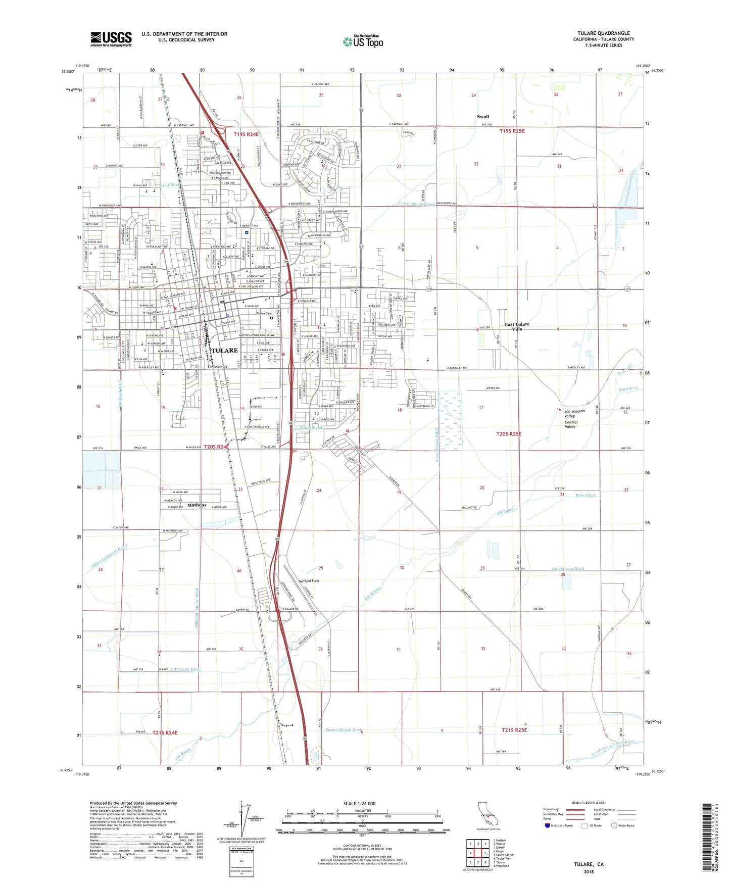
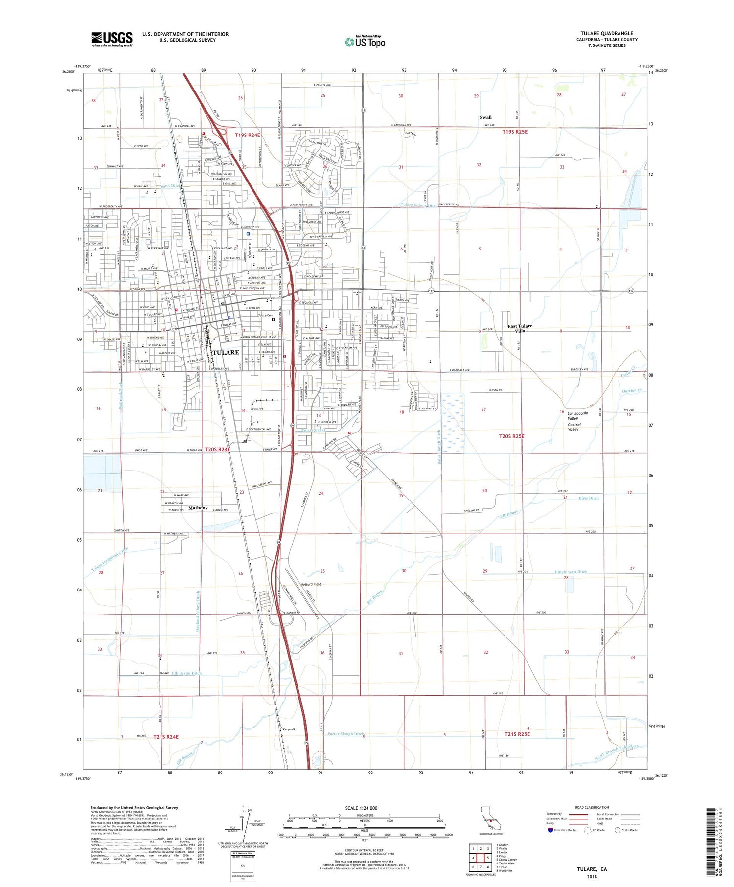
Tulare California US Topo Map
Couldn't load pickup availability
2021 topographic map quadrangle Tulare in the state of California. Scale: 1:24000. Based on the newly updated USGS 7.5' US Topo map series, this map is in the following counties: Tulare. The map contains contour data, water features, and other items you are used to seeing on USGS maps, but also has updated roads and other features. This is the next generation of topographic maps. Printed on high-quality waterproof paper with UV fade-resistant inks.
Quads adjacent to this one:
West: Paige
Northwest: Goshen
North: Visalia
Northeast: Exeter
East: Cairns Corner
Southeast: Woodville
South: Tipton
Southwest: Taylor Weir
This map covers the same area as the classic USGS quad with code o36119b3.
Contains the following named places: Alice G Malcahy Middle School, Anchor Plaza Shopping Center, Assembly of God Church, Babe Ruth Ballpark, Bates Slough Ditch, Bliss School, Burling, Central Bible Baptist Church, Central School, Cherry Avenue Middle School, Church of Christ, Church of God, Church of God in Christ, Church of the Nazarene, City of Tulare, City of Tulare Fire Department Station 1 Headquarters, City of Tulare Fire Department Station 2, City of Tulare Fire Department Station 3, Civic Memorial Building, Cypress Elementary School, East Tulare Villa Census Designated Place, Elba, Elk Bayou 1066 Dam, Elk Bayou Ditch, First Baptist Church, First Christian Church, First Church of Christ Scientist, First Church of God, First Congregational Church, First Lutheran Church, First Methodist Episcopal Church, First Pentecostal Church of Jesus Christ, Foursquare Church, Frank Kohn Elementary School, Garden Elementary School, Heritage Place Shopping Center, Hillman Health Center, Hoffman Dairy, Imhoff, Inside Creek, J and E Dairy, KGEN-AM (Tulare), Kingdom Hall of Jehovahs Witnesses, Kingsview, KJUG-AM (Tulare), Lemstra Bardsley Dairy, Lerda Dairy, Lifestar Ambulance, Lincoln Elementary School, Live Oak Middle School, Live Oak Park, Lourenco Dairy, Main Branch Tulare County Library, Mancebo Jerseys Dairy, Maple Elementary School, Matheny Census Designated Place, Mefford Field, Monte Vista Shopping Center, Mount Olive Baptist Church, Oakland Colony Ditch, Oakland Colony School, Outside Creek, Palo Verde Elementary School, Pentecostal Holiness Church, Pleasant Elementary School, Porter Slough Ditch, Railroad Ditch, Reorganized Church of Jesus Christ of Latter Day Saints, Riverbend Dairy, Roosevelt Elementary School, Saint Aloysius Roman Catholic Church, Saint Aloysius School, Saint Johns Episcopal Church, Sand Ditch, SCE San Joaquin Heliport, Seventh Day Adventist Church, Sierra View Dairy, Sundale Elementary School, Swall, Triple H Dairy, Triple H Dairy Number 2, Tulare, Tulare Adult School, Tulare Canal, Tulare Cemetery, Tulare Colony Ditch, Tulare County Fairgrounds, Tulare County Fire Department Battalion 1 Tulare Fire Station 25, Tulare County General Hospital, Tulare County Health Clinic, Tulare Golf Links, Tulare High School Farm, Tulare Police Department, Tulare Post Office, Tulare Public Library, Tulare Regional Medical Center, Tulare Technical Prepartory School, Tulare Town and Country Village Shopping Center, Tulare Western High School, Valley High School, Veterans Memorial Building, Wilson Elementary School, Woodlake High School, ZIP Code: 93274