MyTopo
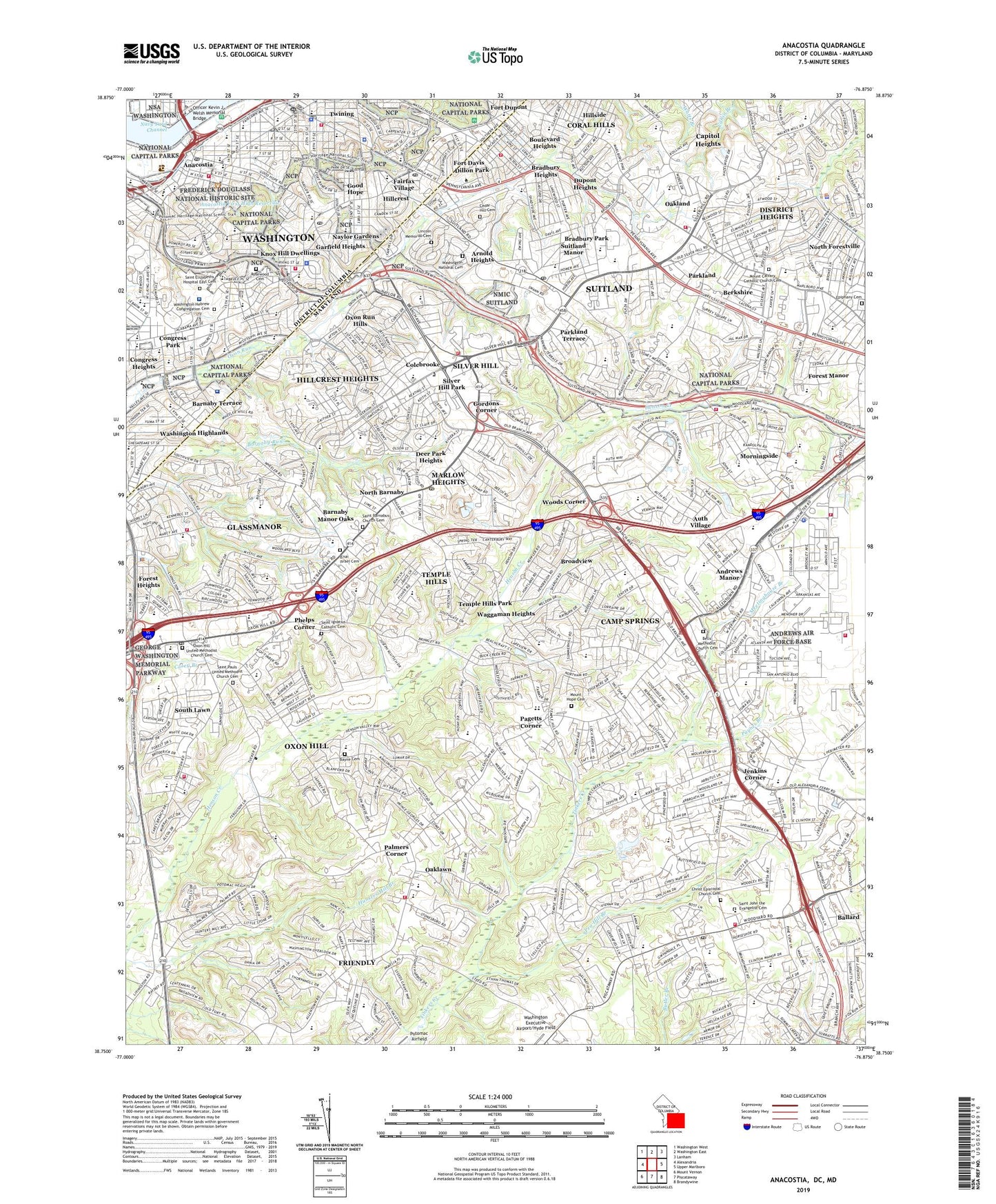
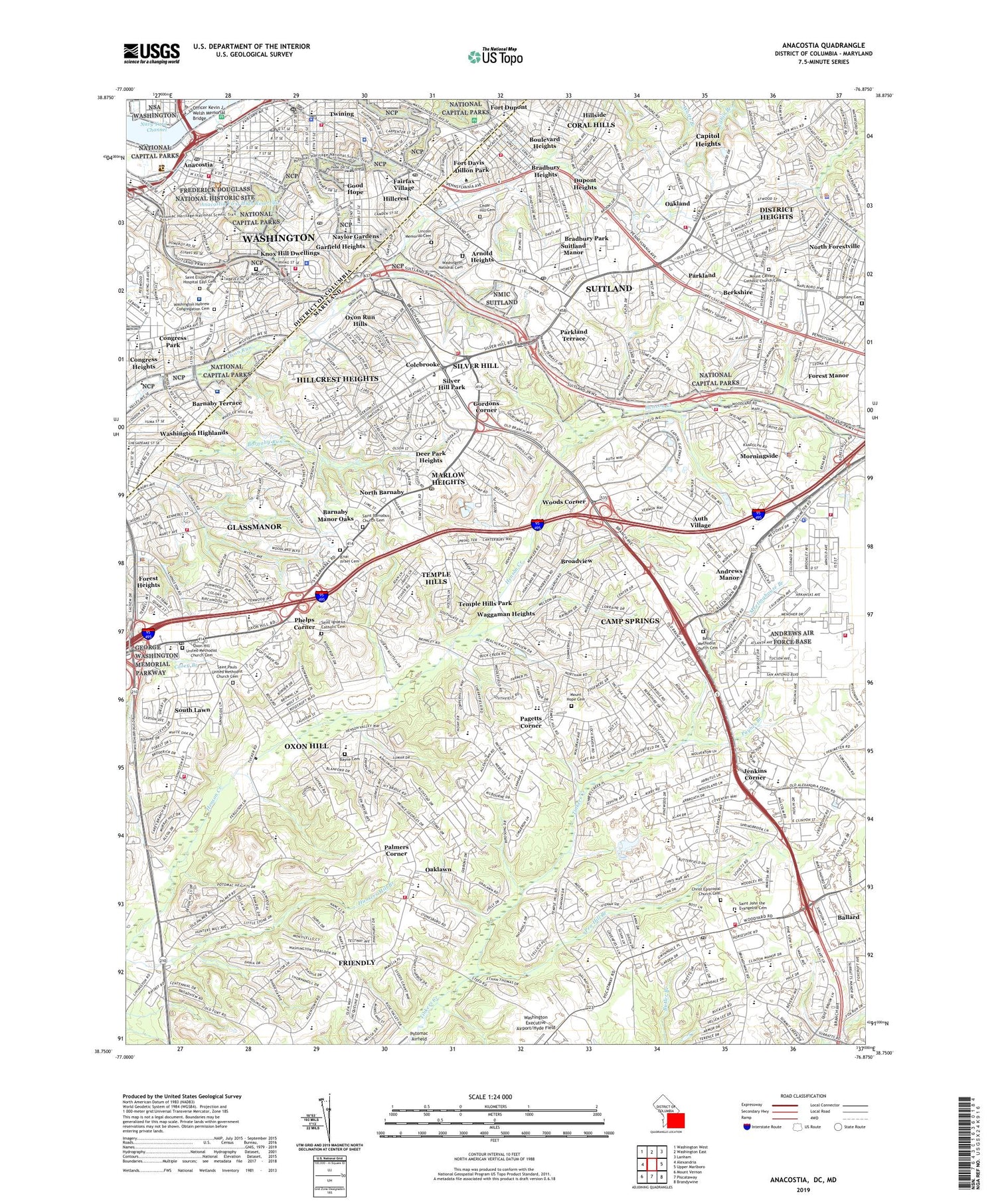
Anacostia District of Columbia US Topo Map
Couldn't load pickup availability
2023 topographic map quadrangle Anacostia in the state of District of Columbia. Scale: 1:24000. Based on the newly updated USGS 7.5' US Topo map series, this map is in the following counties: District of Columbia, Prince George's. The map contains contour data, water features, and other items you are used to seeing on USGS maps, but also has updated roads and other features. This is the next generation of topographic maps. Printed on high-quality waterproof paper with UV fade-resistant inks.
Quads adjacent to this one:
West: Alexandria
Northwest: Washington West
North: Washington East
Northeast: Lanham
East: Upper Marlboro
Southeast: Brandywine
South: Piscataway
Southwest: Mount Vernon
Contains the following named places: Alger Park, Allentown Outlet Mall Shopping Center, Allentown Road Recreation Center, Allentown Way Shopping Center, Anacostia, Anacostia First High Reservoir, Anacostia Fitness Center, Anacostia Flats, Anacostia Metro Station, Anacostia Park Section C, Anacostia Park Section D, Anacostia Recreation Center, Anacostia Station, Andrews Manor, Andrews Manor Shopping Center, Apple Grove, Apple Grove Plantation, Arnold Heights, Auth Village, Avalon Playground, Ballard, Barnaby Manor Oaks, Barnaby Run Park, Barnaby Terrace, Barry Farm Playground, Barry Farm Pool, Barry Farms, Barry Farms Recreation Center, Battery Ricketts, Berkshire, Berkshire Neighborhood Park, Berry Farms Recreation Center, Boulevard Heights, Bradbury Heights, Bradbury Heights Recreation Center, Bradbury Park, Branch Avenue Metro Station, Branch Avenue Plaza Shopping Center, Branchwood Shopping Center, Broad Creek, Broadview, Buena Vista, Camp Meigs, Camp Springs, Camp Springs Census Designated Place, Camp Springs Recreation Center, Capital Gateway Business Park, Capitol Heights Plaza Shopping Center, Carey Branch, City of District Heights, Clinton, Clinton Park Shopping Center, Clinton Plaza Shopping Center, Colebrooke, Conants Mill, Congress Heights Metro Station, Congress Heights Playground, Congress Heights Recreation Center, Congress Park, Constellation Center Office Park, Coral Hills, Coral Hills Census Designated Place, Creston Farm, Deer Park Heights, Dillon Park, District 12 Oxon Hill, District 6 Spauldings, District 9 Surratts, District Heights, Douglas Patterson Park, Douglass Community Center, Douglass Dwellings, Douglass Junior Recreation Center, Douglass Memorial Home, Douglass Pool, Douglass Recreation Center, Dupont Heights, Dupont Heights Park, Dupont Park, Eastern Power Boat Club, Fairfax Village, Fairlawn, Fairlawn Recreation Center, Ferebee-Hope Recreation Center, Forest Heights, Forest Manor, Forest Village Park Mall Shopping Center, Fort Davis, Fort Davis Recreation Center, Fort Dupont, Fort Stanton Park, Fort Stanton Pool, Fort Stanton Recreation Center, Frederick Douglass National Historic Site, Friendly, Friendly Hills, Garfield Heights, Glassmanor, Good Hope, Good Hope Hill, Good Hope Marketplace, Good Hope Tavern, Gordons Corner, Great Eastern Plaza Shopping Center, Haddocks Hill, Hart Recreation Center, Hayden-Johnson Recreation Center, Henson Creek Golf Course, Hillcrest, Hillcrest Heights, Hillcrest Park, Hillcrest Recreation Center, Hillside, Hunters Mill Recreation Area, Hunts Corner, Hyde Field Estates, Iverson Mall Shopping Center, Jenkins Corner, Kastle Estates, Ketcham Recreation Center, Knox Hill Dwellings, L'Enfant Square, Livingston Square Shopping Center, Malcolm X Recreation Center, Manchester Estates, Marbury Plaza, Marlow Heights, Marlow Heights Park, Marlow Heights Shopping Center, Marlow Shopping Center, Mary Church Terrell Recreation Center, Meetinghouse Branch, Michael J Polley Neighborhood Park, Middleton Farm, Morningside, Murray Hill, Navy Yard Pier 1, Navy Yard Pier 2, Navy Yard Pier 3, Navy Yard Pier 4, Navy Yard Wharf, Naylor Gardens, Naylor Road Metro Station, Neighborhood Park, North Barnaby, North Barnaby Recreation Area, North Forestville, Oakcrest Country Club, Oakland, Oaklawn, Old National Race Course, Orr Recreation Center, Owens Road Park, Oxon Hill, Oxon Hill Plaza Shopping Center, Oxon Hill-Glassmanor Census Designated Place, Oxon Run Hills, Oxon Run Parkway, Oxon Run Pool, Pagetts Corner, Pagetts Corner Shopping Center, Palmers Corner, Parkland, Parkland Shopping Center, Parkland Terrace, Paynes Branch, Pea Hill Branch, Penn Branch, Penn Branch Shopping Center, Penn-Mar Shopping Center, Pennsylvania Avenue Hights, Pennsylvania Station Shopping Center, Phelps Corner, Pinewood Park, Pope Branch Park, Potomac Business Park, Potomac City, Randle Highlands, Rivertowne Commons Shopping Center, Rosecroft Park, Rosecroft Raceway, Rosecroft Shopping Center, Ruppert Home, Sandersons Tavern, Savoy Playground, Savoy Recreation Center, Shipley Terrace, Silver Hill, Silver Hill Industrial Center, Silver Hill Park, Silver Hill Plaza Shopping Center, Skyland Shopping Center, South Forestville Park, South Lawn, Southeast Quadrant, Southeast Tennis and Learning Center, Southern Avenue Metro Station, Southern Avenue Shopping Center, Squires Woods, Suitland, Suitland Bog Park, Suitland Manor, Suitland Metro Station, Suitland Park, Sunrise Village Shopping Center, Temple Hills, Temple Hills Park, Temple Hills Recreation Center, Town of Morningside, Turner Playground, Twining, Twining Park, Twining Square, Uniontown Station, United States Botanic Garden - Poplar Point Nursery, USS Barry, Wacotchtank, Waggaman Heights, Washington Highland Recreation Center, Washington Highlands, West Over View, Wilkinson Recreation Center, Woodberry Forest Recreation Center, Woodberry Square Shopping Center, Woodland, Woodland Terrace Recreation Center, Woods Corner, World's Largest Chair, ZIP Codes: 20020, 20735, 20744, 20745, 20746, 20747, 20748