MyTopo
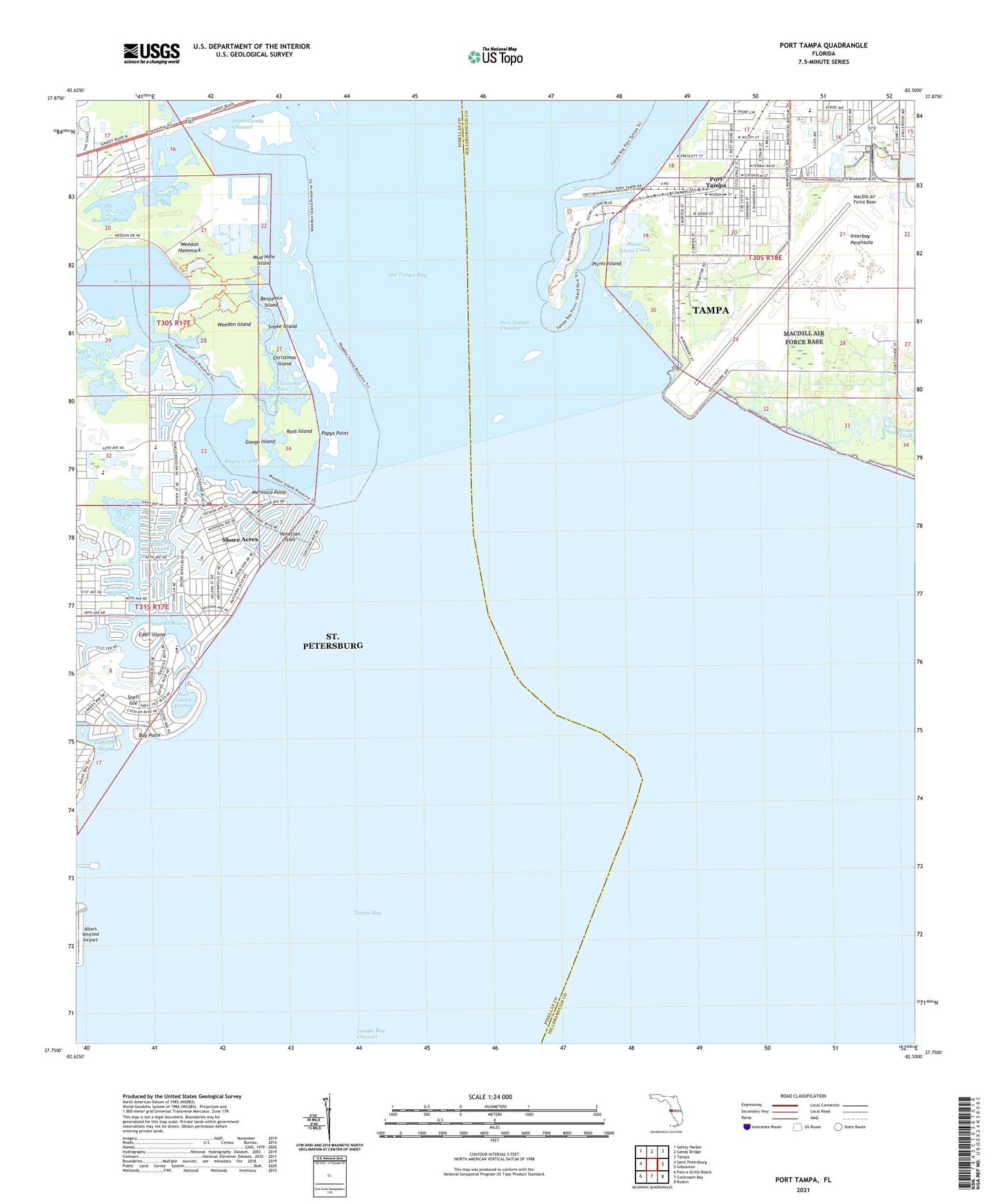
Port Tampa Florida US Topo Map
Couldn't load pickup availability
2024 topographic map quadrangle Port Tampa in the state of Florida. Scale: 1:24000. Based on the newly updated USGS 7.5' US Topo map series, this map is in the following counties: Hillsborough, Pinellas. The map contains contour data, water features, and other items you are used to seeing on USGS maps, but also has updated roads and other features. This is the next generation of topographic maps. Printed on high-quality waterproof paper with UV fade-resistant inks.
Quads adjacent to this one:
West: Saint Petersburg
Northwest: Safety Harbor
North: Gandy Bridge
Northeast: Tampa
East: Gibsonton
Southeast: Ruskin
South: Cockroach Bay
Southwest: Pass-a-Grille Beach
This map covers the same area as the classic USGS quad with code o27082g5.
Contains the following named places: Arrowhead Park, Bay Point, Bayou Grande, Benjamin Island, Butterfly Lake, Christmas Island, Christmas Pass, Coon Hammock Creek, Crescent Park, Denver Park, Dewey Railroad Station, Eden island, Edgemoor Park, Flora Wylie Park, Florida Power Corporation Bartow Steam Plant, Gandy, Googe Island, Interbay Peninsula, Jack Puryear Park, Land Lackey Estates, Macdill Air Force Base, MacDill Air Force Base, MacDill Air Force Base Fire Department, MacDill Railroad Station, Manors at Manhattan, Masters Bayou, Mermaid Point, Monnette, Mud Hole Island, Northeast Presbyterian Church, Palm Grove, Papys Point, Picnic Island, Picnic Island Creek, Pinewood, Placido Bayou, Port Tampa, Port Tampa Channel, Port Tampa City Library, Port Tampa Communities, Port Tampa Dock, Port Tampa Point, Port Tampa Post Office, Port Tampa Railroad Station, Riviera Bay, Robinson Heights, Robinson High School, Ross Island, Saint Clements Episcopal Church, Saint Petersburg Fire and Rescue Station 12 Shore Acres, Saint Raphael School, Saint Thomas Episcopal Church, Shore Acres, Shore Acres Elementary School, Shore Acres Mini Park, Shore Acres Park, Shriners Hospital for Crippled Children, Smacks Bayou, Snake Island, Snell Island Harbor, Snell Isle, Snell Isle Park, South Gandy Channel, Spitler Park, Sunniland, Sunset, Tampa Bay, Tampa Bay Channel, Tampa Bay Community Hospital, Tampa Fire and Rescue Station 19, Venetian Isles, Weedon Hammock, Weedon Island, Weedon Island State Preserve, West Port, West Shore Elementary School, Whitted Airport Runway Extension Obstruction Light, WLFF-AM (Saint Petersburg), WMTX-FM (Clearwater), WRBQ-AM (Saint Petersburg), WTSP Radio Tower, WWRM-FM (Saint Petersburg), ZIP Codes: 33616, 33703