MyTopo
Athens West Georgia US Topo Map
Couldn't load pickup availability
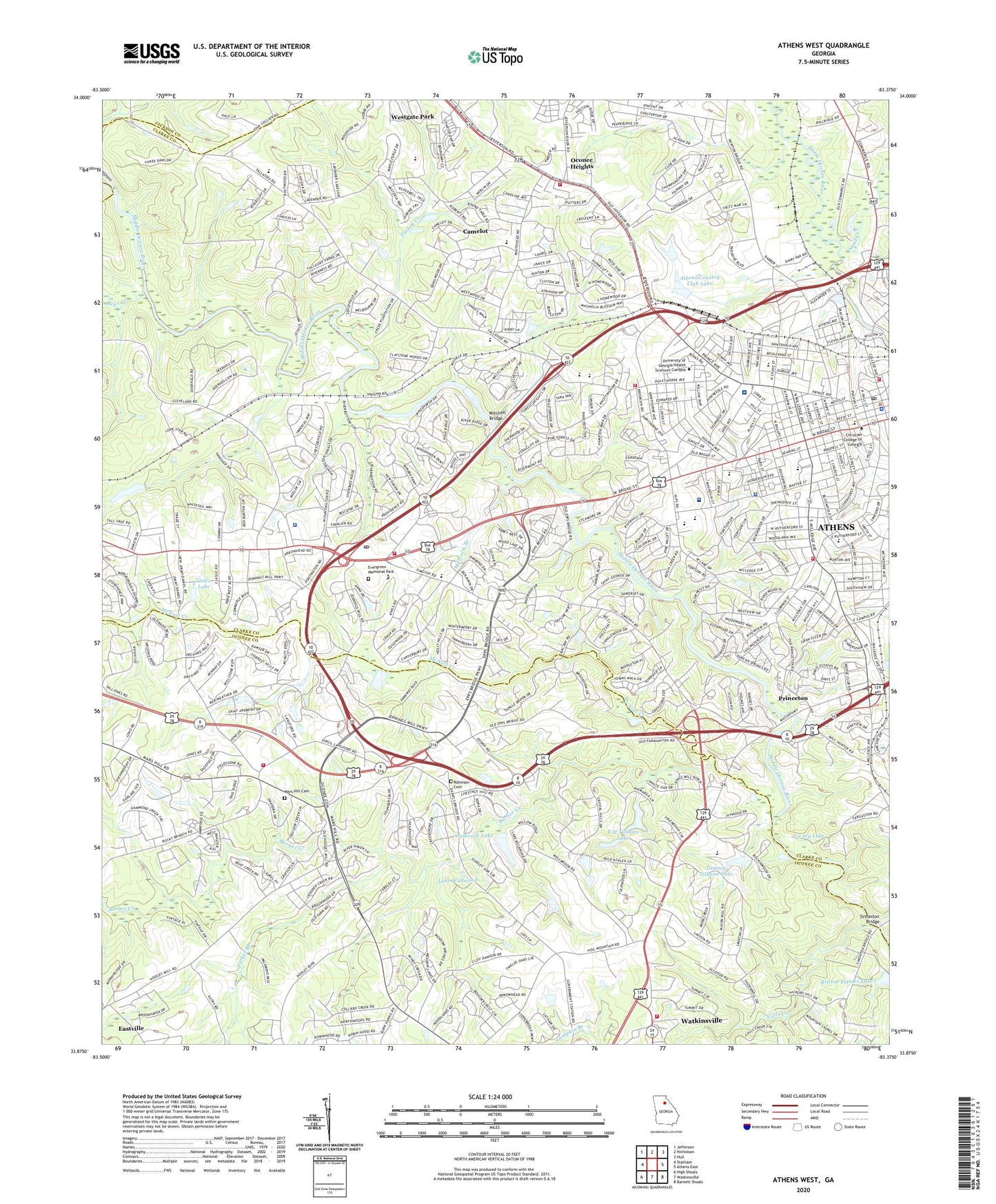
2024 topographic map quadrangle Athens West in the state of Georgia. Scale: 1:24000. Based on the newly updated USGS 7.5' US Topo map series, this map is in the following counties: Clarke, Oconee, Jackson. The map contains contour data, water features, and other items you are used to seeing on USGS maps, but also has updated roads and other features. This is the next generation of topographic maps. Printed on high-quality waterproof paper with UV fade-resistant inks.
Quads adjacent to this one:
West: Statham
Northwest: Jefferson
North: Nicholson
Northeast: Hull
East: Athens East
Southeast: Barnett Shoals
South: Watkinsville
Southwest: High Shoals
This map covers the same area as the classic USGS quad with code o33083h4.
Contains the following named places: Adams, Alps Road Elementary School, Alps Shopping Center, Athena Square Shopping Center, Athens, Athens Academy, Athens Area Vocational School, Athens City Hall, Athens Commerce Park, Athens Country Club, Athens Country Club Dam, Athens Country Club Lake, Athens High and Industrial School, Athens Memorial Park, Athens Plaza Shopping Center, Athens Promenade Station New Post Office, Athens Regional Library, Athens Seventh Day Adventist School, Athens Speedway, Athens Trade Center, Athens West Shopping Center, Athens Zoo, Athens-Clarke County Public Health Center, Barber Creek, Barber Creek Estates, Barrow Elementary School, Baxter Street Shopping Center, Bear Creek, Bedgood, Beechwood Hills, Beechwood Shopping Center, Bel Air Heights, Bells Lake Dam Two, Ben Burton Park, Ben Dowdy, Berkley Hills, Beverly Heights, Birchmore, Bishop Park, Bloomfield Street Historic District, Bogart Division, Boggs Hall, Bolton Hall, Boulevard Historic District, Bowder Park, Briar Lakes, Britain Estates, Britton Estates Lake, Broad Acres, Broadacres Homes, Brooks Hall, Brookwood Estates, Brumby Hall, Burney - Harris - Lyons Middle School, Caldwell Hall, Calls Creek, Camelot, Candler Hall, Canyon Creek, Chadds Walk, Charter Winds Hospital, Chase Street Elementary School, Chatham Park, Chestnut Grove School, Christian College of Georgia, Church Hall, Clark Howell Hall, Clarke Central High School, Clarke Crossing Shopping Center, Clarke Middle School, Classic City High School, Classic City Performance Learning Center, Cleveland School, Cobbham, Cobbham Historic District, Coggins Park, Coles Lake, College Avenue School, Country Club Estates, Creekwood Estates, Crestwood Golf Course, Creswell Hall, Crystal Hills, Daniel Plantation, Danson Woods, Davis Estates, Dawson Hall, Dean William Tate Student Center, Dearing Street Historic District, Demosthenian Hall, Den Court, Downtown Athens Historic District, Downtown Post Office, Echo Brook Park, Elder, Epps Bridge, Epps Bridge Crossing, Evergreen Memorial Park, Fairfield, Fieldstone, Five Points Shopping Center, Foley Field, Forest Heights, Fowlers Mill, Garden Hills, Georgia Square Mall Shopping Center, Georgian Hills, Gilbert Health Center, Glen Oaks, Glenwood, Goldkist Industrial Park, Grove School, Habersham Hills, Hanover, Hickory Hill, Highland Oaks, Hodges Mill, Holiday Estates, Holly Hills, Homes of Mansfield, Homewood Hills, Homewood Shopping Center, Huntington Park, Indian Hills, Inverness Farms, Ivywood, J S Ivy Dam, J S Ivy Lake, Jefferson Valley, Jennie Arnold Edwards Camp, Jennings Mill, Kingswood, Knottingham, Knox Institute, Lake Forest, Lake Wildwood, Lumpkin Law School, Malcolm Branch, Mars Hill Cemetery, McDonald, McNutt Creek, Milledge Avenue Historic District, Milledge Circle Historic District, Mitchell Bridge, Mitchell Dam, Moss Side, Navy Supply Corps School Athens, North Athens School, North Place, North Valley, Northridge Park, Northwest Woods, Oak Ridge, Oconee Heights, Oglethorpe Avenue Elementary School, Oglethorpe Avenue Historic District, Overlook Village, Paper Mill Bridge, Paradise Valley Industrial Park, Park View Homes, Parker Branch, Parkview Recreation Center, Perimeter Square Shopping Center, Piedmont Athens Regional Medical Center, Pine Forest, Pine Lake, Pinecrest Hills, Prince Avenue Christian School, Princeton, Quailwood, Ramble Hills, Rebel Hill, Reese Street Historic District, Riverhaven Estates, Riverside, Riverside Hills, Riverside Park, Robinson Cemetery, Rock Spring Recreation Center, Rollingwood, Rushwood, Sagamore Hills, Saint Joseph Catholic School, Saint Josephs School, Saint Mary's Hospital, Saint Marys Hospital Heliport, Sandy Creek, Sedgefield, Sherwood Forest, Shops of South Athens Shopping Center, Simonton Bridge, Skyline Park, Spartan Lane, Stonebridge, Stonehenge, Summit Grove, Swanson, Sykes Mill, T M Tillman Lake, Tallassee Estates, Tallassee Farms, Tanglebrook, Tanglewood, Tara Way, Tee Pee, Timothy Christian Academy, Timothy Estates, Timothy Road Elementary School, Tommie Tillman Lake, Tommie Tillman Number One Dam, Tommie Tillman Number Two Dam, Turkey Creek, Welbrook Lake, West Broad Street School, West Hancock Avenue Historic District, Westchester, Westchester Shopping Center, Westgate Park, Westwood Hills, WGAU-AM (Athens), Whitehead Road Elementary School, Wildwood Dam, Wilkins Industrial Park, Windy Creek, Windy Hill, WMSL-FM (Athens), Woodhaven High Ridge, Woodland Hills, Woodlands, Woodlawn Historic District, Woodridge North, WRFC-AM (Athens), WXAG-AM (Athens), ZIP Codes: 30606, 30609