MyTopo
Mableton Georgia US Topo Map
Couldn't load pickup availability
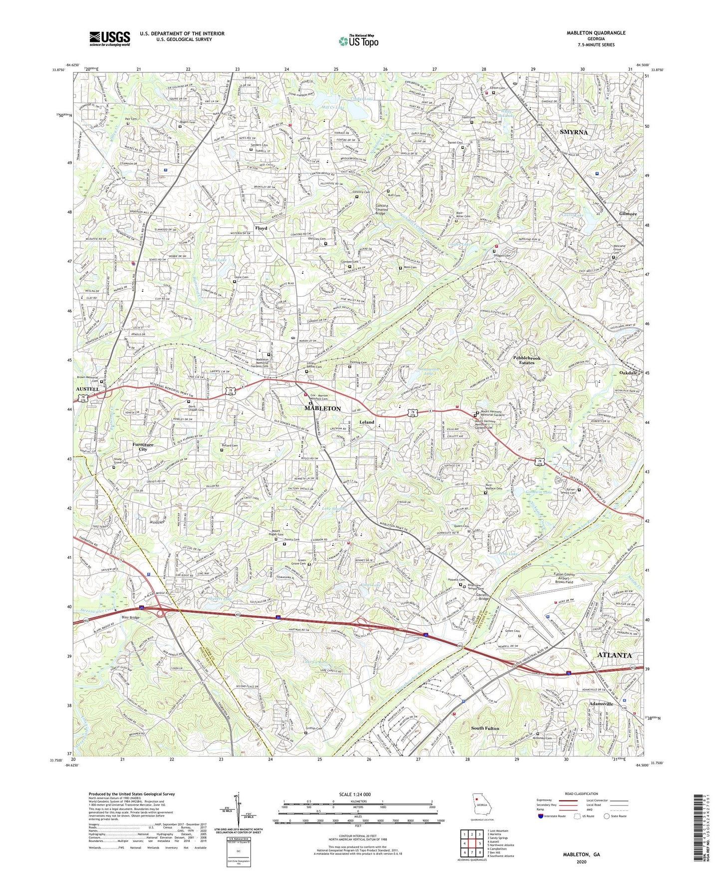
2024 topographic map quadrangle Mableton in the state of Georgia. Scale: 1:24000. Based on the newly updated USGS 7.5' US Topo map series, this map is in the following counties: Cobb, Fulton, Douglas. The map contains contour data, water features, and other items you are used to seeing on USGS maps, but also has updated roads and other features. This is the next generation of topographic maps. Printed on high-quality waterproof paper with UV fade-resistant inks.
Quads adjacent to this one:
West: Austell
Northwest: Lost Mountain
North: Marietta
Northeast: Sandy Springs
East: Northwest Atlanta
Southeast: Southwest Atlanta
South: Ben Hill
Southwest: Campbellton
This map covers the same area as the classic USGS quad with code o33084g5.
Contains the following named places: Adamsville, Adamsville Elementary School, Adamsville Health Center, Apostolic Christian Training Center, Askew Park, Atlanta Fire / Rescue Station 9, Austell Floyd Shopping Center, Bakers Ferry Residential Facility, Bankhead Courts, Blackhawk Hills, Blair - Miller Cemetery, Blair Bridge, Blue Ridge Manor, Boulder Park, Boulder Vista, Brenda View, Brookside Village, Brown Elementary School, Brown Memorial Cemetery, Bryant Elementary School, Bullard Cemetery, Butternut Creek, Camerons Crossing, Camp Highland, Cardell, Cardinal Lake Dam, Carroll Heights, Castle Lake, Castle Lake Dam, Castlewood Estates, Chattahoochee Technical College South Cobb Campus, Cherokee Hills, Cherokee Trail, Cheyenne Estates, Cindys Lake, City of Smyrna, Clay Elementary School, Clay Plaza Shopping Center, Cobb County Fire and Emergency Services Station 1, Cobb County Police Department Precinct 2, Cobb General Hospital Heliport, Cobb Market Fair Shopping Center, Collier Drive Park, Collier Heights Branch Atlanta-Fulton Public Library, Collier Heights Plaza Shopping Center, Combee Cemetery, Concord Cemetery, Concord Covered Bridge, Concord Square Post Office, Cooper Lake, Country Manor, Covered Bridge Montessori School, Cox - Morrow - Mitchell Cemetery, Creelwood, Creelwood Trailer Park, Cumberland Christian Academy, Daniel Cemetery, Daniell Dam, Daniell Lake, Davis Chapel Cemetery, Dickson Shopping Center, Discovery Industrial Park, Dodgen Cemetery, Dunn Hill, Edison Cemetery, Ellison Estates, Emory Adventist Hospital, Fairburn Heights, Flagstone, Fleming Cemetery, Floyd, Floyd Middle School, Ford Heights, Fulton County Airport-Brown Field, Fulton County Industrial Park, Furniture City, G A Towns Elementary School, Gann Cemetery, Gardner Woods, Garretts Bridge, Glore Cemetery, Glore Lake, Glore Lake Dam, Goodwin Lake, Goodwin Lake Dam, Gordon Acres, Gordon Heights, Gordon Hills Estates, Gordon Road Village Shopping Center, Gordon Woods, Green Cemetery, Green Grove Cemetery, Greenbrook, Griffin Middle School, Griffith Cemetery, Harmony Leland Elementary School, Hawthorne Plaza Shopping Center, HCA Parkway Medical Center Heliport, Hembree Hills, Hicks Lake, Hicks Lake Dam, Hillcrest Valley, Howard, Howells Cemetery, Hurt Road Park, Imagine International Academy of Mableton, International Welcome Center, Interstate West Industrial Park, Ivey Terrace, Ivy Point, James Acres, Jetts Lake, Johnstons Crossing, Kennedy, King Springs Elementary School, King Springs Shopping Center, Kings Lake, Knox Springs Estates, L P Miles Elementary School, La Bama, Lake Ca Reca, Lake Court Park, Lake Starling, Lake Starling Dam, Lakeside, Laurel Lake, Laurel Lake Dam, Lee Industrial Park, Leland, Lindley Middle School, Lindley Sixth Grade Academy, Lions Park, Little Bethel Cemetery, Lizzie, Lodge West, Mableton, Mableton Census Designated Place, Mableton Christian Academy, Mableton Division, Mableton Elementary School, Mableton Memorial Gardens Cemetery, Mableton Post Office, Mableton Shopping Center, Mableton Walk Shopping Center, Margaret Fain Elementary School, McDonald Cemetery, Mercer University Douglas County Regional Academic Center, Mickeys Market Place Shopping Center, Milford Lookout Tower, Mill Creek Lake, Mill Creek Lake Dam, Moss Cemetery, Mount Harmony Memorial Gardens, Mount Harmony Memorial Gardens Cemetery, Mount Pisgah Cemetery, Mount Pisgah Estates, Nickajack, Nickajack Creek, Nickajack Elementary School, Nickajack Park, Nickjack, Normandy Forest, Northridge Shopping Center, Nottingham, Oak Hill, Oakhill, Old Clay Cemetery, Pace-Wallace Cemetery, Pair Cemetery, Parkway Regional Hospital, Pebblebrook Estates, Pebblebrook High School, Pine Creek, Pineview, Pisgah Forest, Pleasant Acres, Quails Nest, Queen Cemetery, Queens Lake, Queens Lake Dam, Queens Lake Estates, Rhyne Park, Ridgeview Institute, Riverside Intermediate School, Riverside Primary School, Riverside School, Riverview Temple Cemetery, Rogers Cemetery, Ruff Cemetery, Ruffs Mill, Russell Elementary School, Saddleback Ridge, Sanders Cemetery, Sanders Elementary School, Sandy Creek, Seybert Lake, Seybert Lake Dam, Shady Grove Cemetery, Sherwood Estates, Six Flags Industrial Park, Six Flags Over Georgia, Sky View Elementary School, Smyrna Division, Smyrna Hospital Heliport, Songwood, South Cobb Branch Cobb County Public Library, South Cobb County Community Center, South Cobb High School, South Cobb Industrial Park, South Cobb Shopping Center, Strickland and Peek Cemetery, Summerlin Lake, Summerlin Lake Dam, Summit Ridge, The Bluffs Office Park, The Village Mobile Home Park, Thompson Park, Timber Ridge Camp, Tolleson Park, Trademore Park, Trinity Cemetery, Turner - Sewell Cemetery, Vel Manor, Village at Westfork Shopping Center, Wallace Park, Welcome Grove Cemetery, Wellstar Cobb Hospital, Whisperwoods, White Oak Lake, Whitefield Academy, Wilson Mill Park, Witt Acres, ZIP Codes: 30082, 30126, 30168


