MyTopo
Nebo Georgia US Topo Map
Couldn't load pickup availability
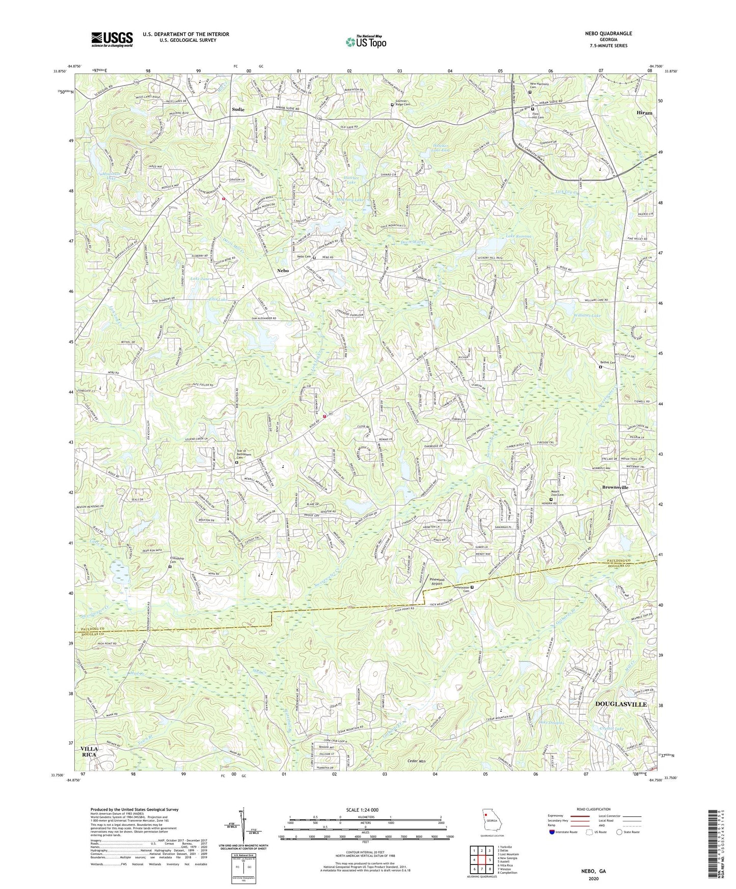
2024 topographic map quadrangle Nebo in the state of Georgia. Scale: 1:24000. Based on the newly updated USGS 7.5' US Topo map series, this map is in the following counties: Paulding, Douglas. The map contains contour data, water features, and other items you are used to seeing on USGS maps, but also has updated roads and other features. This is the next generation of topographic maps. Printed on high-quality waterproof paper with UV fade-resistant inks.
Quads adjacent to this one:
West: New Georgia
Northwest: Yorkville
North: Dallas
Northeast: Lost Mountain
East: Austell
Southeast: Campbellton
South: Winston
Southwest: Villa Rica
This map covers the same area as the classic USGS quad with code o33084g7.
Contains the following named places: Allgood Elementary School, Arbor Walk, Asbury Woods, Ash, Ashley Acres, Austin Middle School, Baggett Elementary School, Bakers Bridge Estates, Baldwin Hills, Bethany Church, Bethel Cemetery, Bethel Church, Black Forest, Bromley Estates, Brownsville, Brownsville Crossing Shopping Center, Brownsville Square Shopping Center, Callie Harbin Church, Campground School Estates, Cedar Mountain Church, City of Hiram, Cochran Ridge Cemetery, Cochran Ridge Church, Colonial Hills, Corn Crib Mobile Home Park, Cotton Field Plaza Shopping Center, Country Club Estates, Crystal Lake, Crystal Lake Dam, Davis Mill Creek, Deer Run, Denton Estates, Denton Farms, Dobbins Middle School, Douglas Lake Dam, Dugan Elementary School, Ellis Lake, Ellis Lake Dam, Emanuel Church, Emanuel Church Cemetery, Emerald Forest, Fleetwood Hills, Flint Hill Cemetery, Flint Hill Church, Friendship Cemetery, Friendship Church, Full Gospel Mission, Gordon Estates, Great Commission Fellowship, Green Meadows, Greenfield Summit, Hal Hutchens Elementary School, Hartfield Acres, Hartfield Estates, Hatcher Lake, Hatcher Lake Dam, Hatcher Lake East, Hatcher Lake East Dam, Hiram Church, Hiram Division, Hiram Paulding Church of God, Hollyberry, Home Place Acres, Honeysuckle Plantation, Jones Lake, Jones Lake Dam, Joseph Estates, Lake Douglas, Lake Jane, Lake Jane Dam, Lake Romona, Lake Romona Dam, Lake Swan, Lick Log Creek, Lincoln Heights, Little Creek, Maranatha Church, Martinville Church, Maude P Ragsdale Library, McCravy Lake, McCravy Lake Dam, Meadowbrook, Mill Creek, Mill Creek Place, Mount Nebo Church, Mount Zion Cemetery, Mount Zion Church, Mountain Lake, Mountainview Estates, Mud Creek, Nebo, Nebo Cemetery, Nebo Elementary School, Nebo Gardens, Nebo Place, New Harmony Cemetery, New Harmony Church, North Douglas Elementary School, Oak Creek, Oberlochen, Old Davis Mill Estates, Other, P B Ritch Elementary School, Paces Lakes, Paces Meadows, Panter Elementary School, Paulding County Country Club, Paulding County Fire and Rescue Bureau Station 5, Paulding County Fire Station 10, Pilgrim North, Pine Forest, Pine Ridge Church, Pinewood Airport, Pumpkinvine Creek Structure Number 26 Dam, Quail Run, Quail Run East, Ridge Corners, Ridgeview Heights, Roach Prospect, Seventh Day Church, Souls Harvest Worship Center, South Paulding High School, South Paulding Middle School, South Paulding Woods, Sprayberry Farms, Spring Ridge Estates, Star of Bethelhem Church, Star of Bethlehem Cemetery, Strip 92 Shopping Center, Sudie, Sudie Crossing Shopping Center, Swan Lake, Sweetwater Cemetery, Sweetwater Church, Sweetwater Estates, The Highlands, The South Forty, Town Branch, Victoria Cove, Waterfall Branch, Westwood Heights, Williams Lake, Williams Lake Dam, ZIP Codes: 30134, 30141