MyTopo
Fox Lake Illinois US Topo Map
Couldn't load pickup availability
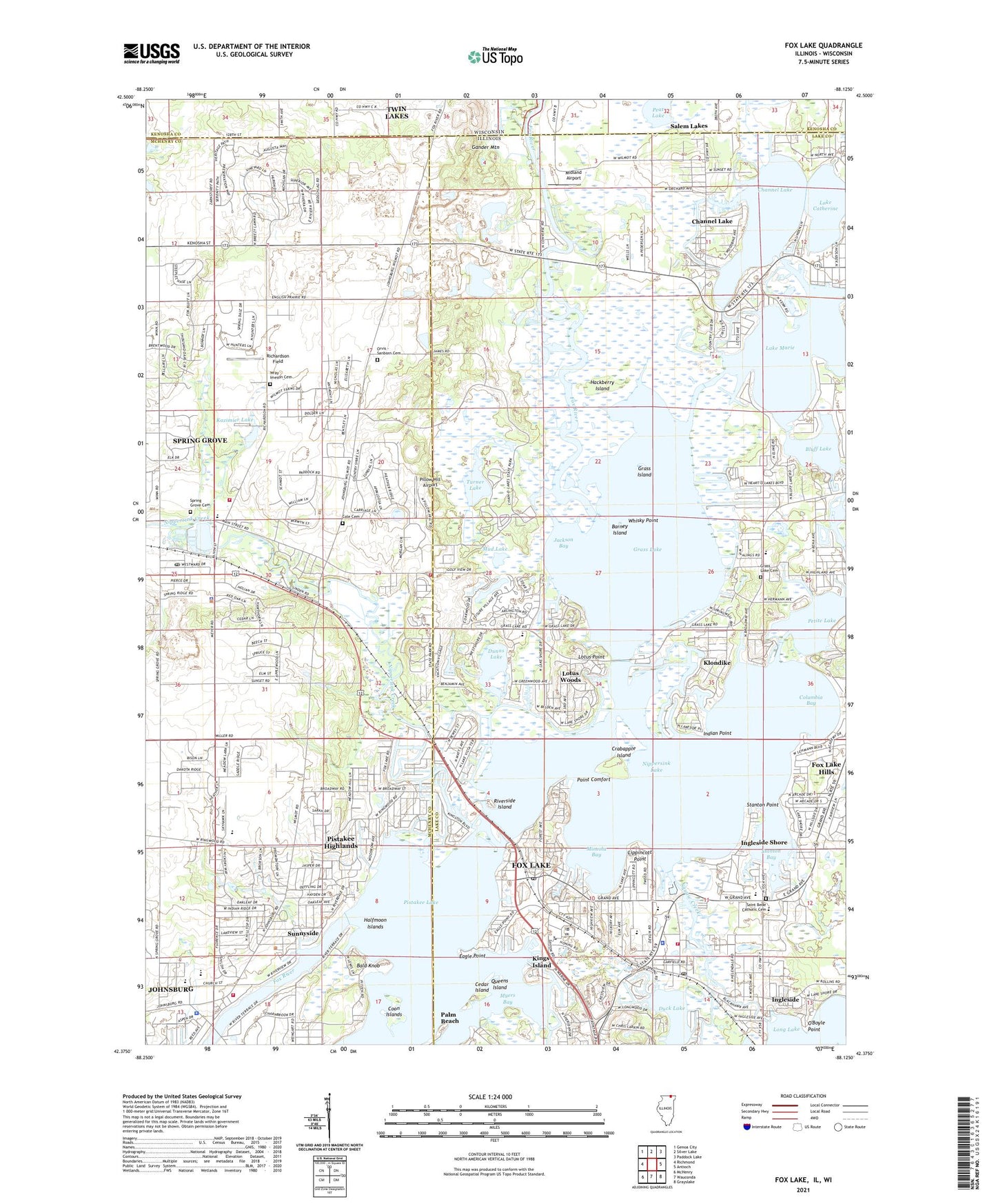
2024 topographic map quadrangle Fox Lake in the states of Illinois, Wisconsin. Scale: 1:24000. Based on the newly updated USGS 7.5' US Topo map series, this map is in the following counties: Lake, McHenry, Kenosha. The map contains contour data, water features, and other items you are used to seeing on USGS maps, but also has updated roads and other features. This is the next generation of topographic maps. Printed on high-quality waterproof paper with UV fade-resistant inks.
Quads adjacent to this one:
West: Richmond
Northwest: Genoa City
North: Silver Lake
Northeast: Paddock Lake
East: Antioch
Southeast: Grayslake
South: Wauconda
Southwest: McHenry
Contains the following named places: Antioch Airport, Arrow Heliport, Bald Knob, Barney Island, Bluff Lake, Catfish Cove Picnic Area, Cedar Island, Chain O'Lakes State Park, Channel Lake, Channel Lake Census Designated Place, Channel Lake School, Cole Cemetery, Columbia Bay, Coon Islands, Crabapple Island, Creek School, Deer Path Picnic Area, Duck Lake, Dunns Lake, Eagle Lake 3WR1658 Dam, Eagle Lake 7, Eagle Point, English Prairie Post Office, English Prairie School, Forest School, Fox Lake, Fox Lake Country Club, Fox Lake Fire Department Station 1, Fox Lake Fire Department Station 2, Fox Lake Fire Department Station 4, Fox Lake Hills, Fox Lake Hills Census Designated Place, Fox Lake Police Department, Fox Lake Post Office, Fox Lake Regional Sewage Treatment Plant, Fox Lake Seaplane Base, Gander Mountain, Gander Mountain Forest Preserve, Gavin Bog and Prairie Nature Preserve, Gavin Central Elementary School, Gavin North Intermediate School, Grant High School, Grant Woods Forest Preserve, Grass Island, Grass Lake, Grass Lake Cemetery, Grass Lake Elementary School, Hackberry Island, Halfmoon Islands, Hickory Grove Picnic Area, Honeysuckle Hollow Camping Area, Indian Point, Ingleside, Ingleside Post Office, Ingleside Shore, Jackson Bay, James C Bush Elementary School, Johnsburg, Johnsburg High School, Johnsburg Junior High School, Johnsburg Middle School, Kazimier Lake, Kazimier Lake Dam, Kings Island, Klondike, Lake Catherine, Lake Catherine Census Designated Place, Lake Marie, Lakeland Shopping Center, Lippincott Point, Long Lake, Long Lake Census Designated Place, Lotus Point, Lotus Woods, McHenry Township Fire Protection District Station 2, Meadowland Community Church, Midland Airport, Mineola Bay, Mount Hope United Methodist Church, Mud Lake, Mudlake West Youth Group Camping Area, Muller Chapel, Nippersink Canoe Base County Park, Nippersink Creek, Nippersink Lake, Oak Grove Picnic Area, Oak Point Day Use Area, O'Boyle Point, Oriole Springs Orchard, Orvis - Sanborn Cemetery, Palm Beach, Peat Lake, Peat Lake State Natural Area, Petite Lake, Pickerel Point, Pike Marsh Picnic Area, Pillow Hill Airport, Pistakee, Pistakee Highlands, Pistakee Highlands Census Designated Place, Pistakee Lake, Point Comfort, Prairie View Camping Area, Precision Chrome Heliport, Queens Island, Richardson Farm, Richardson Field, Richardsons Landing Strip, Riverside Island, Saint Bede School, Saint Peter Church, Spring Grove, Spring Grove Cemetery, Spring Grove Elementary School, Spring Grove Fen Nature Preserve, Spring Grove Fire Protection District, Spring Grove Police Department, Spring Grove Post Office, Spring Lake, Squaw Creek, Stanton Bay, Stanton Point, Stanton School, Sunnyside, Sunnyside Village Hall, Thomas Memorial County Park, Township of Burton, Turner Lake, Turner Lake Fen Nature Preserve, Turner Lake South Camping Area, Village of Fox Lake, Village of Johnsburg, Village of Johnsburg Police Department, Village of Spring Grove, Weingart Road Sedge Meadow Nature Preserve, Whisky Point, Wilmot Hills Raceway, Wray - Imeson Cemetery, ZIP Codes: 60020, 60081