MyTopo
Rockford South Illinois US Topo Map
Couldn't load pickup availability
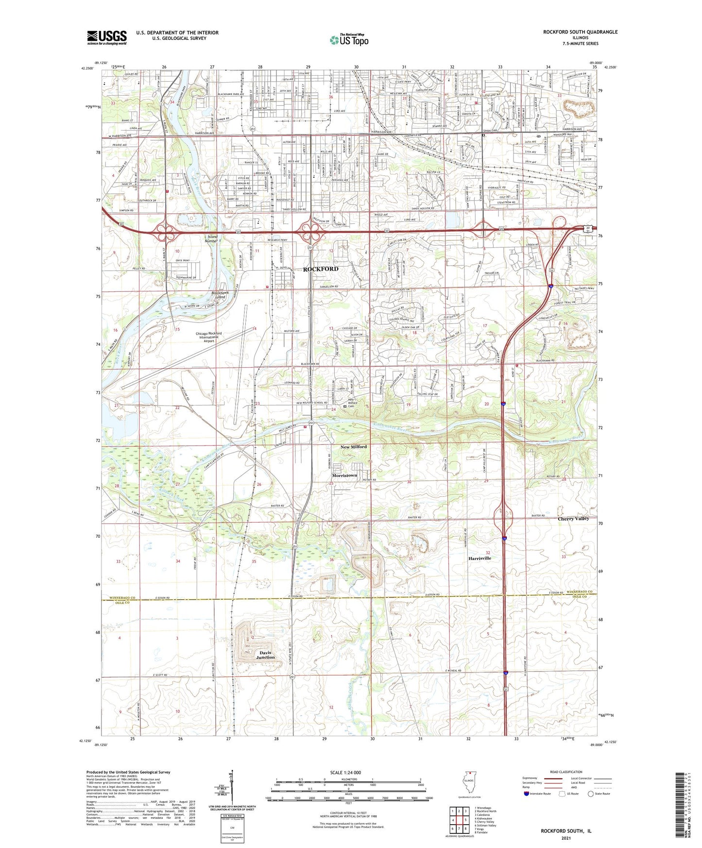
2024 topographic map quadrangle Rockford South in the state of Illinois. Scale: 1:24000. Based on the newly updated USGS 7.5' US Topo map series, this map is in the following counties: Winnebago, Ogle. The map contains contour data, water features, and other items you are used to seeing on USGS maps, but also has updated roads and other features. This is the next generation of topographic maps. Printed on high-quality waterproof paper with UV fade-resistant inks.
Quads adjacent to this one:
West: Kishwaukee
Northwest: Winnebago
North: Rockford North
Northeast: Caledonia
East: Cherry Valley
Southeast: Fairdale
South: Kings
Southwest: Stillman Valley
This map covers the same area as the classic USGS quad with code o42089b1.
Contains the following named places: Alpine Business Park, Alpine Village Shopping Center, Anns Mobile Home Park, Apostolic Mission Church, Arthur Froberg Elementary School, Atwood Estates, Atwood Park Estates, Atwood Park Estates Playground, Bernard W Flinn Middle School, Bethel Baptist Church, Bethlehem Lutheran Church, Blackcrest, Blackhawk Fire Station, Blackhawk Island, Blackhawk Park, Blessed Hope Bible Church, Brooke Road United Methodist Church, Buckbee School, Burr Oak Acres, Calvary Church, Calvary Church of Christ, Calvary Lutheran Church, Camp Grant Station, Camp Hillcrest, Camp Rotary, Canyon Ridge, Cathedral Baptist Church, Cathedral Baptist School, Cherry Valley Fire Station 2, Cherry Valley Township Hall, Cheyenne Heights, Chicago/Rockford International Airport, Christ the Savior Orthodox Church, Church of Christ, Church of God, Clarks Mobile Home Park, Coreys Bluff, Coventry Hills, Cutler Farm, Davey Farm, Don Schmid Park, Eagles Christian Fellowship Church, East Rock Industrial Park, Eastern Star Home, Eleventh Street Plaza Shopping Center, Factory Addition, Faith Center, Faith Tabernacle Church, Faith Tabernacle School, Fire Station Number 13, First Church of the Nazarene, First General Baptist Church, Franklin Gardens, Friendship General Baptist Church, GEM Field Park, Grange Hall, Grant Park, Greater Rockford Academy, Green View Heights, Greendale, Greenridge Estates, Gunsolas School, Harmon Park, Harrison Avenue Gardens, Harrisville, Hickory View Estates, Indian Village, Island Number 1, Jamestown Park, Jefferson Heights Baptist Church, Julia Lathrop Elementary School, Ken-Rock Community Center, Ken-Rock Park, Kilbuck Bluffs County Forest Preserve, Killbuck Creek, Kingdom Hall of Jehovahs Witnesses-South, Kinseys Little Farms, Kinson School, Kishwaukee County Forest Preserve, Kishwaukee Glen, Kishwaukee Gorge North County Forest Preserve, Kishwaukee Gorge South County Forest Preserve, Klehm County Forest Preserve, Korean Presbyterian Church, Lighthouse Temple Pentecostal Church, Lindberg Park, Linview, Lonesome Acres, Luther Early Learning Academy, Mancuso Village Park, Mariposa Playground, Maywood Church, Maywood Manor, Miller School, Montessori Learning Center, Morningside Church, Morris Kennedy Middle School, Morristown, Mount Olive Baptist Church, Mulford Highlands, Mulford Quarry Number 139, Muslim Community Center, New Life Fellowship Church, New Milford, New Milford Cemetery, New Milford Church, New Milford Elementary School, New Milford Fire Station, New Milford School, New Milford Station, Normandy Heights, Orchard Hills Landfill, Pelley Road Christian Fellowship Church, Peterson School, Pine Manor, Pinetree Park, Ravinia Park, Regional Learning Center, Resurrection Life Foursquare Church, River Forest, River Grove, Riverdahl Elementary School, Riverside School, Riverview Mobile Home Park, Rock River Elementary School, Rockford Fire Department - Station 11, Rockford Fire Department - Station 7, Rockford Head Start Ken-Rock, Rockford Pistol Range, Rockford Post Office, Rockford Rotary County Forest Preserve, Rockford Sanitary District Disposal Plant, Rockview Quarry, Rolling Green Elementary School, Saint Edwards Community Center, Saint Edwards Roman Catholic Church, Saint Edwards School, Saint Luke Missionary Baptist Church, Samuelson Road Church of the Nazarene, Sandy Hollow Golf Course, Sarbrook Park, Sawyer Playground, Scott School, Seth B Atwood Park, Shepherd of the Valley Lutheran Church, Silver Hill Church, Silver Hills, Skyview Center, Souls Harbor Church, South Bend School, South Main Church, South Park Covenant Church, Southeast Park, Southgate Shopping Center, Starkey School, Swan Hillman Elementary School, Thomas Jefferson High School, Thompson Elementary School, Township of Rockford, Trailside County Forest Preserve, Union Cemetery, Vandercook School, Vasa Park, Victory Church, Victory Homes, Village of New Milford, Whitehead Elementary School, William Nashold Elementary School, Winnebago County Landfill, Winnebago Court, Woodside Congregational Church, Woodside General Baptist Church, WRRR-AM (Rockford), York Retreat, ZIP Code: 61109