MyTopo
Ault Kentucky US Topo Map
Couldn't load pickup availability
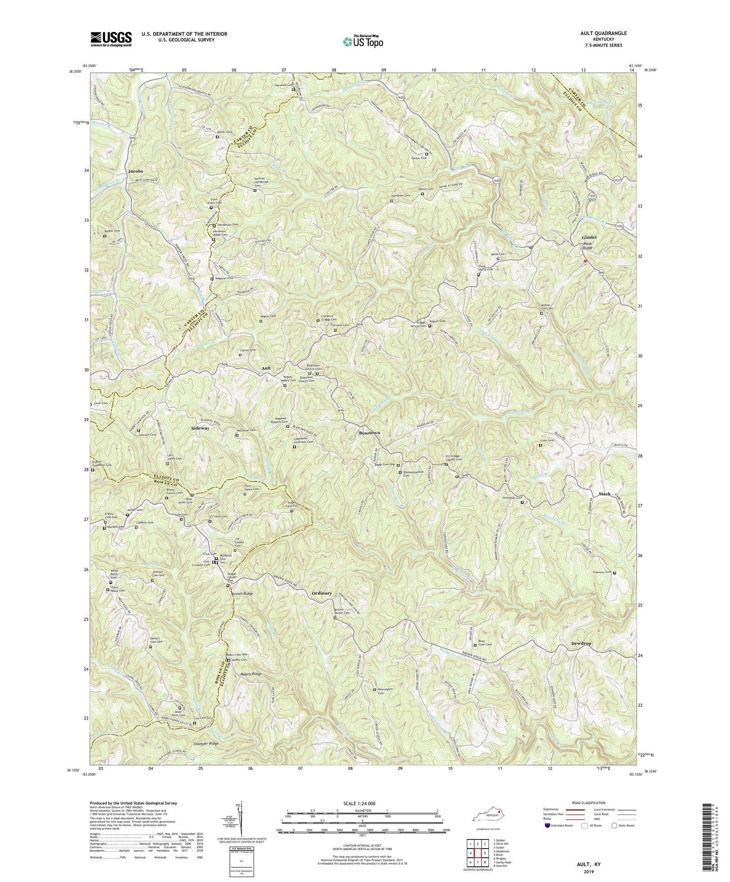
2022 topographic map quadrangle Ault in the state of Kentucky. Scale: 1:24000. Based on the newly updated USGS 7.5' US Topo map series, this map is in the following counties: Elliott, Carter, Rowan. The map contains contour data, water features, and other items you are used to seeing on USGS maps, but also has updated roads and other features. This is the next generation of topographic maps. Printed on high-quality waterproof paper with UV fade-resistant inks.
Quads adjacent to this one:
West: Haldeman
Northwest: Soldier
North: Olive Hill
Northeast: Grahn
East: Bruin
Southeast: Isonville
South: Sandy Hook
Southwest: Wrigley
This map covers the same area as the classic USGS quad with code o38083b2.
Contains the following named places: Arabs Fork, Ault, Ault Post Office, Barker Cemetery, Barnett Cemetery, Bates Branch, Beartown, Beartown Church, Beartown Church Cemetery, Beartown School, Birch Branch, Blankenbeckler Cemetery, Boggs Cemetery One, Brown - Porter Cemetery, Brown Fork, Brown Ridge, Brown-Fannin Cemetery, Bryant-Goodman Cemetery, Bunker Hill School, Catron Cemetery, Clarence Scaggs Cemetery, Clark - Harris Cemetery, Clay Cemetery, Clay Fork, Clay Fork School, Clayton Post Office, Click Cemetery, Clifty Creek, Concord Enterprise Baptist Church, Concord School, Conn Cemetery, Conn Post Office, Cox Cemetery Two, De Hart Cemetery One, Dew Drop Post Office, Dewdrop, Durham Fork, E Fraley Cemetery, Fairview Cemetery, Fairview Church, Fairview United Methodist Church, Fannin Crossing, Fannin Valley, Fey - Crockett Cemetery, Flannery Cemetery, Flem Jones Cemetery, Forks of Tygarts Post Office, Fraley Cemetery One, Gimlet, Gimlet Post Office, Globe Community, Goodin Branch, Greenbrier Branch, Hanshaw Cemetery, Haywood Cemetery, Henderson Cemetery, Henderson Ridge, Henerson Ridge Cemetery, Highland Forest, Issac Jones Cemetery, J Adkins Cemetery, J M Caudill Cemetery, Jacobs, Jacobs Post Office, Jason Trent Cemetery, Johnson Cemetery, Johnson Cemetery One, Kegley - Mabry Cemetery, Kilgore Cemetery, Laurel School, Leadingham Post Office, Leatherwood Branch, LeMasters - Holbrook Cemetery, Levi Jones Cemetery, Licklog Branch, Longway Post Office, Lovelace Fork, Lowe Cemetery, Lower Clifty Creek, Lyon Cemetery, Lyon School, Mabry Cemetery, Mabry Cemetery One, Mabry Ridge, Manbone Branch, Mart Bear Branch, Mart Whitt Fork, Martha School, Mauk Cemetery, Mauk Ridge, Mauk School, McDaniel Cemetery, McDaniel Cemetery Two, Melvin Conn Cemetery, Mocabee Creek, Moore Cemetery, New Fairview School, New Home School, New Salem School, Norman Henderson Cemetery, Offill's Mill, Ordinary, Ordinary Post Office, Parker Cemetery, Pennington Cemetery, Porter Branch, Porter Cemetery, Proctor Branch, R E Scaggs - Caudill Cemetery, Riley Conn Cemetery, Rock Springs School, Rocky Creek, Route 504 Volunteer Fire Department, Sandy Hook Division, Scaggs-WIlson Cemetery, Shady Grove, Shady Grove Church of God, Shady Grove School, Sideway, Sideway Post Office, Skaggs Caudle Cemetery, Spruce Branch, Stamper Ridge, Stark, Stark Methodist Church, Stark Post Office, Stigall Cemetery Two, Tarkiln Creek, Thompson Cemetery, Trent Black Cemetery, Union School, Upper Clifty Creek, Wagoner Cemetery, Wagoner-Roberts Cemetery, Willie Black Cemetery, Wilson Cox Cemetery, Wimberly Branch, Wimberly School, Winkler Post Office