MyTopo
Creekville Kentucky US Topo Map
Couldn't load pickup availability
Also explore the Creekville Forest Service Topo of this same quad for updated USFS data
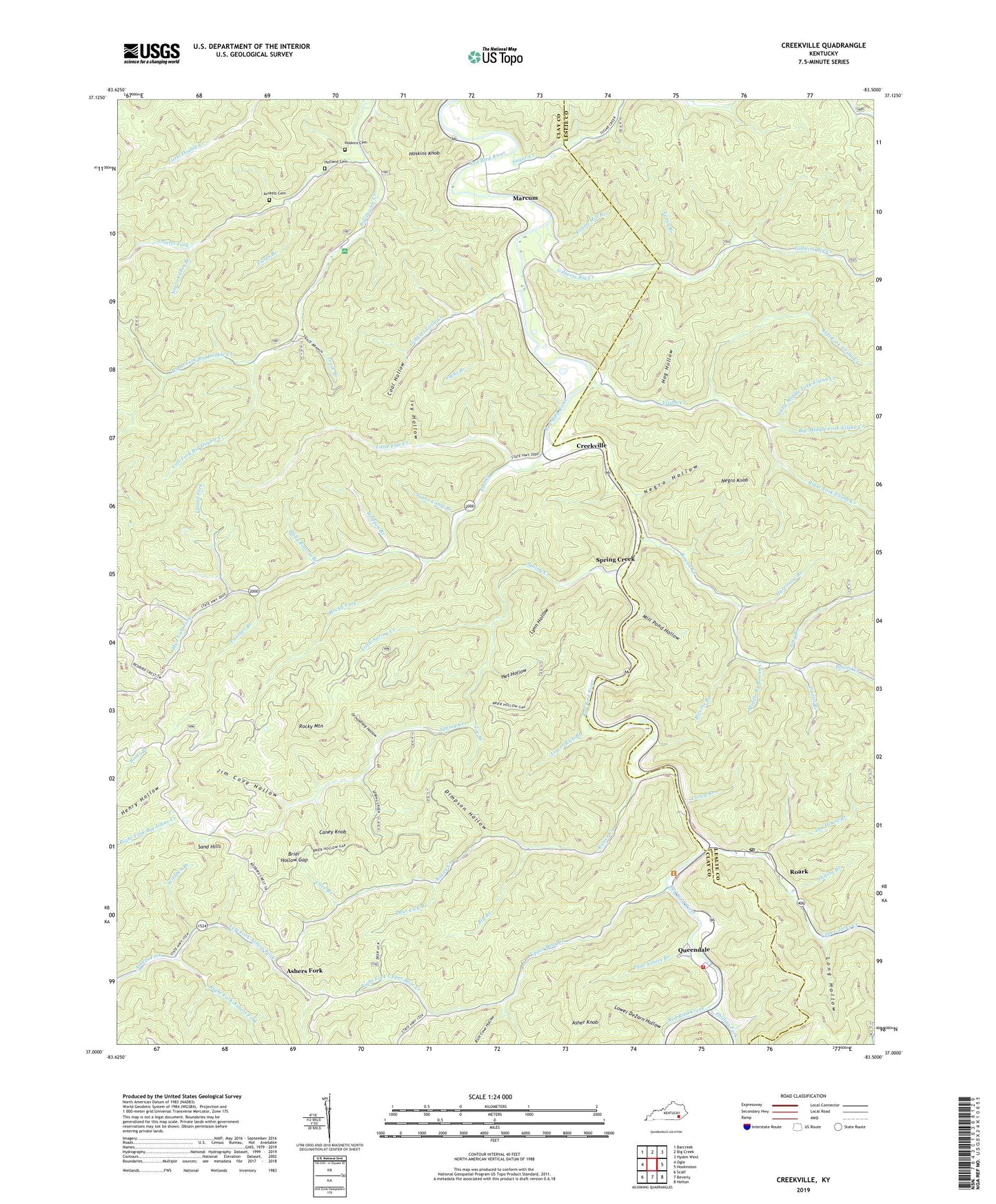
2022 topographic map quadrangle Creekville in the state of Kentucky. Scale: 1:24000. Based on the newly updated USGS 7.5' US Topo map series, this map is in the following counties: Clay, Leslie. The map contains contour data, water features, and other items you are used to seeing on USGS maps, but also has updated roads and other features. This is the next generation of topographic maps. Printed on high-quality waterproof paper with UV fade-resistant inks.
Quads adjacent to this one:
West: Ogle
Northwest: Barcreek
North: Big Creek
Northeast: Hyden West
East: Hoskinston
Southeast: Helton
South: Beverly
Southwest: Scalf
This map covers the same area as the classic USGS quad with code o37083a5.
Contains the following named places: Amy Branch, Arnetts Cemetery, Arnetts Fork, Asher Fork Post Office, Asher Knob, Ashers Fork, Ashers Fork Division, Bear Creek Church, Big Branch, Big Double Creek Picnic Area, Big Middle Fork Elisha Creek, Blevins Branch, Bowen Creek, Bowen Creek Church, Brier Hollow Gap, Caney Branch, Caney Knob, Cave Branch, Coal Hollow, Creekville, Creekville Post Office, Daniel Branch, Deer Lick Branch, Dillion Branch, Dimpson Hollow, Double Creek School, Elisha Creek, Elisha Creek Chapel, Elisha Creek School, Fields Branch, Flat Creek, Flat Creek Church, Flat Creek Mission Church, Gilbert Creek Church, Gilbert Creek School, Gilberts Big Creek, Gilberts Little Creek, Groundhog Hollow, Head of Spring Creek School, Het Hollow, Hog Hollow, Holland Cemetery, Holly Bottom Branch, Hoskins Cemetery, Hoskins Knob, Hurricane Branch, Ivy Hollow, Jacks Branch, Jackson Creek School, Jim Cove Hollow, Joe Branch, Katies Creek, Laurel Fork, Left Fork Ashers Fork, Left Fork Big Double Creek, Left Fork Elisha Creek, Left Fork Upper Bear Creek, Little Flat Creek, Little Middle Fork Elisha Creek, Little Spring Creek, Long Hollow, Lower Bluehole School, Lower Bowen Creek School, Lower DeZarn Hollow, Lower Flat Creek School, Lower Rich Branch, Lower Spring Creek School, Lynn Hollow, Marcum, Marcum Post Office, Middle Branch Bowen Creek, Middle Flat Creek School, Mill Pond Hollow, Mud Lick Church, Mud Lick Fork, Negro Cabin Branch, Negro Hollow, Negro Knob, Old House Branch, Panther Branch, Paul Ashers Branch, Phillips Fork, Pound Mill Branch, Queendale, Red Bird Creek, Red Bird Hospital, Red Bird River Church, Red Bird Volunteer Fire and Rescue, Redbird Crest Trail, Redbird Wildlife Management Area, Rich Cove Hollow, Right Fork Ashers Fork, Right Fork Big Double Creek, Right Fork Elisha Creek, Right Fork Upper Bear Creek, Roark, Roark Post Office, Rocklick Branch, Rocky Fork, Rocky Mountain, Sand Hill School, Sand Hills, Sim Langdon School, Skidmore Post Office, Spring Creek, Spring Creek Post Office, Sugar Camp Branch, Sugar Creek, Trace Branch, Upper Bear Creek, Upper Bear Creek School, Upper Jacks Creek, Van Camp Post Office, Venus Branch, Wolfpen Branch, ZIP Codes: 40827, 40979