MyTopo
Rockholds Kentucky US Topo Map
Couldn't load pickup availability
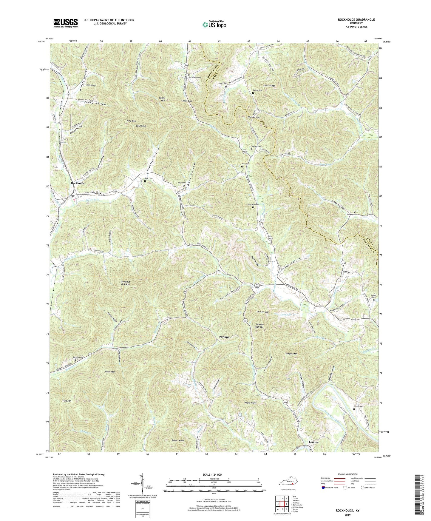
2022 topographic map quadrangle Rockholds in the state of Kentucky. Scale: 1:24000. Based on the newly updated USGS 7.5' US Topo map series, this map is in the following counties: Whitley, Knox. The map contains contour data, water features, and other items you are used to seeing on USGS maps, but also has updated roads and other features. This is the next generation of topographic maps. Printed on high-quality waterproof paper with UV fade-resistant inks.
Quads adjacent to this one:
West: Wofford
Northwest: Vox
North: Corbin
Northeast: Heidrick
East: Barbourville
Southeast: Frakes
South: Saxton
Southwest: Williamsburg
This map covers the same area as the classic USGS quad with code o36084g1.
Contains the following named places: Bald Knob, Bays Cemetery, Bays Hollow, Bear Branch, Berry Hollow, Berry School, Bisco Railroad Station, Brown Cemetery, Brummett Church, Brummett Railroad Station, Brummett School, Bunch Mountain, Caney Branch, Carr Creek, Carter Cemetery, Cedar Gap, Cedar Gap School, Chestnut Oak Mountain, Coffee School, Colonel Hollow, Cotton Creek, Crig Chapel, Darway Railroad Station, Davis Cemetery, Dead Man Hollow, Dowis Chapel, Dowis School, Eatin Fork, Egnar Hollow, Flat Creek Church, Hart Cemetery, Hart School, Hill Chapel, Hill Hollow, Hubbs Hollow, Imperial Hollow, Indian Gap Church, Jacks Fork, Jacks Fork School, John Sharpe Historical Marker, Johnson Hollow, Jones Hollow, Jonny Hollow, King Cemetery, King Mountain, Lawson Chapel, Lawson High Top, Lee Cemetery, Logan Hollow, Louden, Louden Coal Camp, Lower Whetstone School, Mackey Cemetery, Maple Creek School, Maple Ridge, McFarland Cemetery, McNeil Cemetery, McNeil Hollow, Meadow Creek Church, Meadow Grove Church, Melt Hollow, Morgan Hollow, Mosley Branch, Perkins, Perkins Cemetery, Phoebe Fork, Rainey Hollow, Rockholds, Rockholds Census Designated Place, Rockholds Fire Department, Rockholds Post Office, Round Knob, Sawyer Hollow, Sawyer Mountain, Short Ridge, Simp Hollow, Sims Hollow, Smith Cemetery, Stanfield Cemetery, Stoles Fork, Tar Kiln Gap, Turkey Creek, Upper Whetstone School, Walters Cemetery, Watts Creek Jellico Coal Company, Wells School, Whetstone Creek, Whitley Gap, Wood Mountain, ZIP Codes: 40759, 40771