MyTopo
Moss Bluff Louisiana US Topo Map
Couldn't load pickup availability
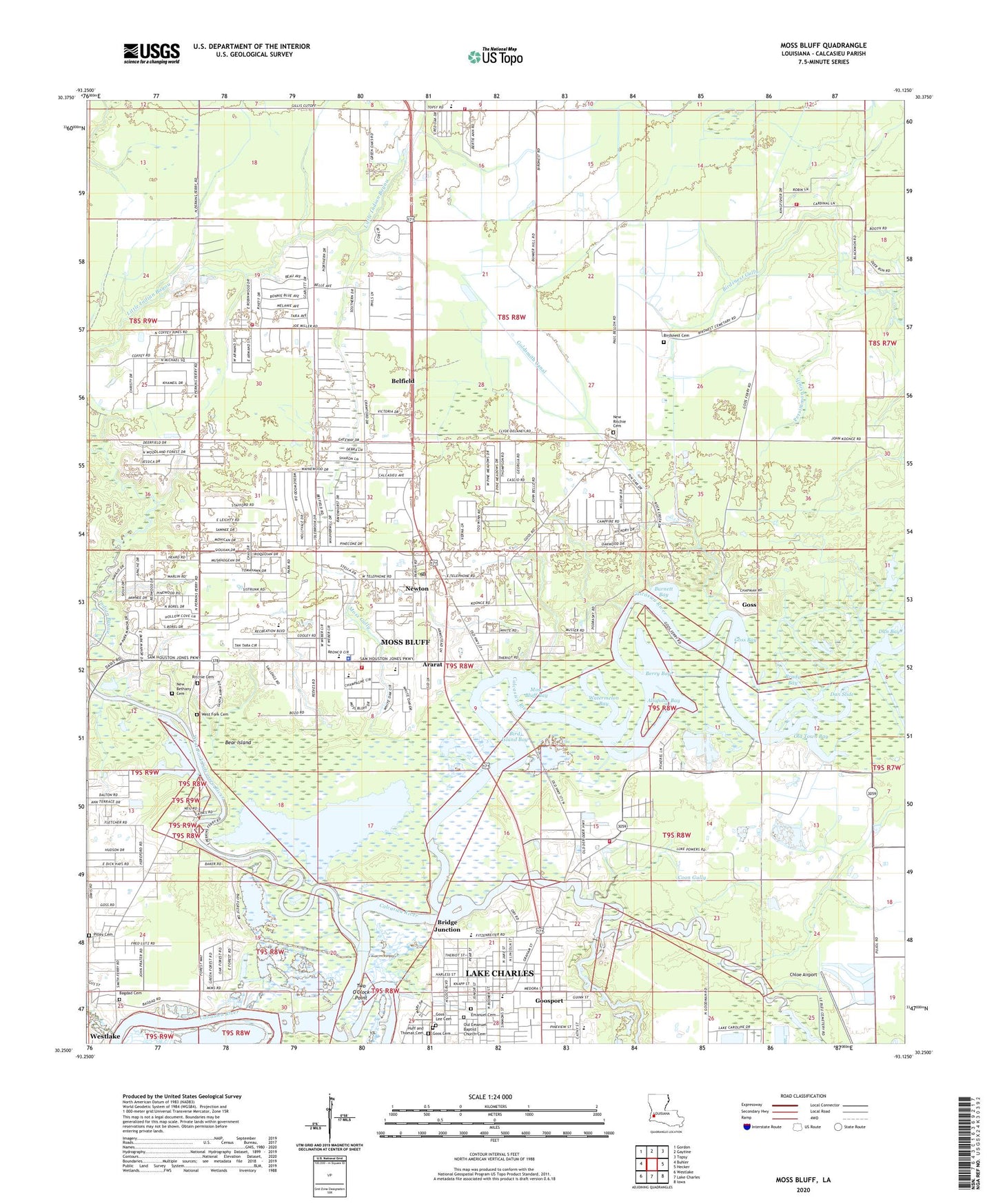
2024 topographic map quadrangle Moss Bluff in the state of Louisiana. Scale: 1:24000. Based on the newly updated USGS 7.5' US Topo map series, this map is in the following counties: Calcasieu. The map contains contour data, water features, and other items you are used to seeing on USGS maps, but also has updated roads and other features. This is the next generation of topographic maps. Printed on high-quality waterproof paper with UV fade-resistant inks.
Quads adjacent to this one:
West: Buhler
Northwest: Gordon
North: Gaytine
Northeast: Topsy
East: Hecker
Southeast: Iowa
South: Lake Charles
Southwest: Westlake
This map covers the same area as the classic USGS quad with code o30093c2.
Contains the following named places: Alligator Bay, Ararat, Bagdad Cemetery, Bayou Shades Mobile Village, Bear Island, Belfield, Berry Bay, Bethel Baptist Church, Bird Island Bay, Birdsnest Cemetery, Birdsnest Gully, Brady Bay, Bridge Junction, Burnett Bay, Cajun Country Volunteer Fire Department, Calcasieu Parish Library Moss Bluff Branch, Calcasieu Parish Ward 1 Fire Protection District 1, Chloe Airport, Combre - Fondel Elementary School, Coon Gully, Country Oaks Mobile Home Park, Cove School, Dan Bay, Dan Slide, Emanuel Cemetery, English Bayou, Epps Branch Library, Evergreen Estates Mobile Home Park, First Apostolic Church, First Baptist Church of Gillis, First Baptist Church of Moss Bluff, First Pentecostal Church of Gillis, Freeman Memorial Church of God in Christ, Gateway Church of God, Gillis, Gillis Elementary School, Gillis-English Bayou Oil Field, Goldsmith Canal, Goos Cemetery, Goosport, Goss, Goss Bay, Greater Ebenezer Missionary Baptist Church, Greater Saint Mary Baptist Church, Jubilee Family Church, Kayouche Coulee, Kingdom Hall of Jehovahs Witnesses, KXZZ-AM (Lake Charles), Martin Luther King Receation Center, Memorial Baptist Church, Merrick Chapel Christian Methodist Episcopal Church, Midway Baptist Church, Moss Bluff, Moss Bluff Bay, Moss Bluff Bible Church, Moss Bluff Calcasieu Parish Sheriff's Office, Moss Bluff Census Designated Place, Moss Bluff Church of Christ, Moss Bluff Elementary School, Moss Bluff Middle School, Moss Bluff Pentecostal Church, Moss Bluff Post Office, Moss Bluff School, Moss Gully, New Life Worship Center, Newton, Northgate Shopping Center, Oakcreek Estates Mobile Home Park, Old Emanuel Baptist Church, Old Town Bay, Our Lady of Fatima Chapel, Parish Governing Authority District 1, Parish Governing Authority District 2, Perkins Ferry, Perkins Ferry Park, Persimmon Gully, Pine Shadows Golf Course, Pleasant Hill Baptist Church, Ray D Molo Middle School, Resurrection Life Church, Richmond Estates Mobile Home Park, Ritchie Cemetery, Riverside Baptist Church, Saint Andrews Episcopal Church, Saint Theodore Catholic Church, Saint Theodore Holy Family Catholic School, Saints Memorial Church of God, Sam Houston High School, Straight Way Baptist Church, Trinity Church of Nazarene, Two O'Clock Point, Union Zion Missionary Baptist Church, Ward 1 Fire District Gillis Station, Ward One, Washington - Marion Magnet High School, Watermelon Bay, West Fork Calcasieu River, West Fork Cemetery, Westlake Church of God, Williams Chapel, ZIP Codes: 70611, 70615