
MyTopo
Camden Maine US Topo Map
Couldn't load pickup availability
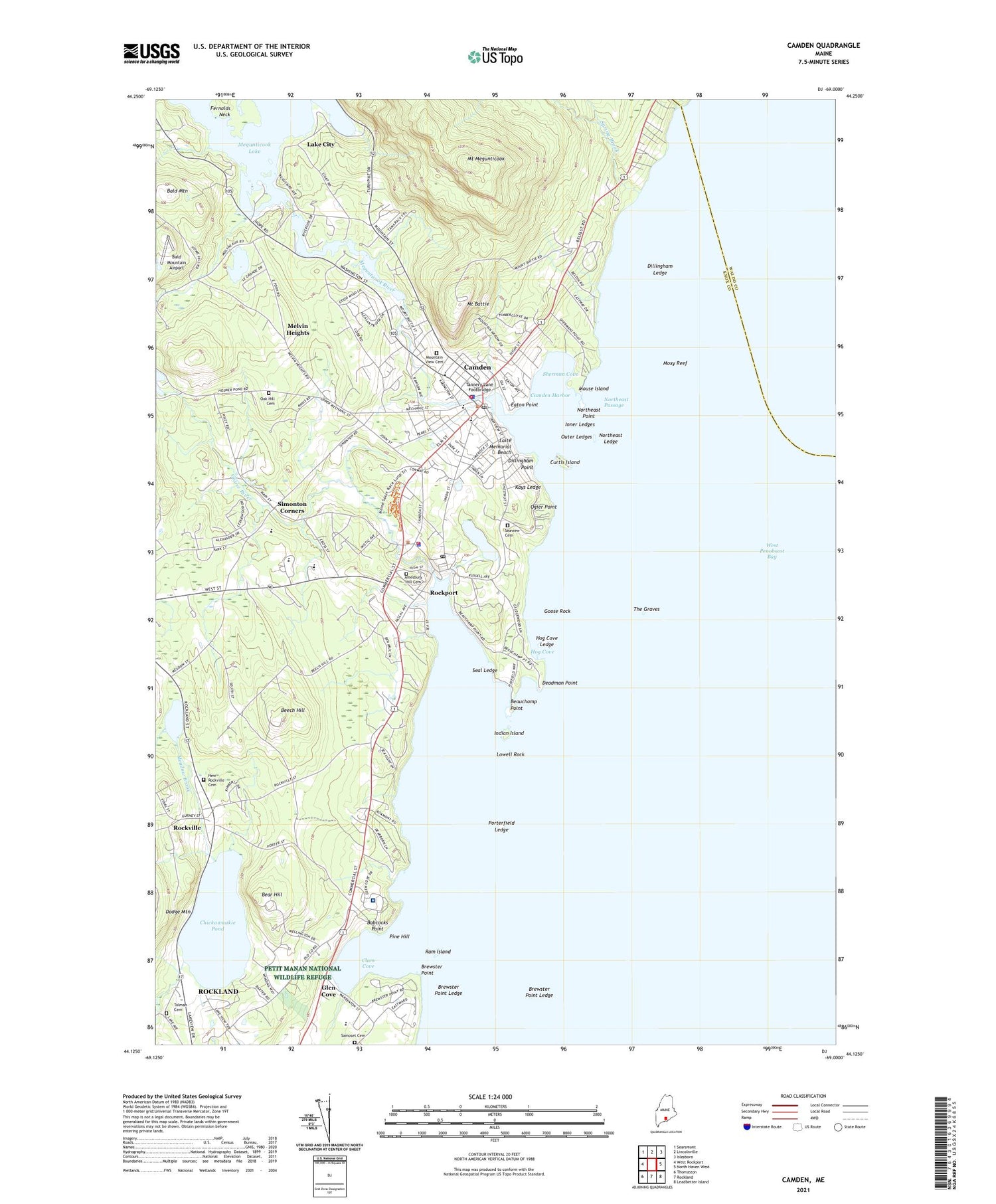
2021 topographic map quadrangle Camden in the state of Maine. Scale: 1:24000. Based on the newly updated USGS 7.5' US Topo map series, this map is in the following counties: Knox, Waldo. The map contains contour data, water features, and other items you are used to seeing on USGS maps, but also has updated roads and other features. This is the next generation of topographic maps. Printed on high-quality waterproof paper with UV fade-resistant inks.
Quads adjacent to this one:
West: West Rockport
Northwest: Searsmont
North: Lincolnville
Northeast: Islesboro
East: North Haven West
Southeast: Leadbetter Island
South: Rockland
Southwest: Thomaston
Contains the following named places: American Boathouse, Amesbury Hill Cemetery, Ashwood Waldorf School, Babcocks Point, Bald Mountain Airport, Bear Hill, Beauchamp Point, Beech Hill, Brewster Point, Brewster Point Ledge, Camden, Camden Amphitheater, Camden Census Designated Place, Camden Fire Department, Camden First Aid Association, Camden Harbor, Camden Health Care Center, Camden Hills Regional High School, Camden Opera House, Camden Opera House Block, Camden Police Department, Camden Post Office, Camden Public Library, Camden Rockport Elementary School, Camden Rockport Middle School, Camden Town Office, Camden Yacht Club, Camden-Rockport Historical Society Building, Chestnut Street Baptist Church, Chestnut Street Historic District, Chickawaukie Pond, Chickawaukie Pond Dam, Children's House Montessori School, Christian Science Reading Room, Clam Cove, Conway House Museum, Cramer Park, Curtis Island, Curtis Island Light, Curtis Island Park, Deadman Point, Dillingham Ledge, Dillingham Point, Eaton Point, Elm Street School, First Congregational Church, Glen Cove, Goose River, Goose Rock, Great Brook, High Street Historic District, Highland Mill Mall, Hog Cove, Hog Cove Ledge, Indian Island, Indian Island Light Station, Inner Ledges, Kays Ledge, Knox Mill Dam, Knox Mill Museum, Knox Mill Pond, Knox Woolen Mills, Laite Memorial Beach, Lake City, Lilly Pond, Lowell Rock, Maces Pond, Maiden Cliff Trail, Maine Coast Artists Gallery, Mary E Taylor Middle School, Mary Meeker Cramer Museum, Meguniticook by the Sea Campground, Megunticook Lake East Dam, Megunticook Lake West Dam, Megunticook River, Melvin Heights, Merryspring Park, Mount Battie, Mount Battie Trail, Mount Megunticook, Mountain View Cemetery, Mouse Island, Moxy Reef, New Rockville Cemetery, North East Mobile Health Ambulance Service, Northeast Ledge, Northeast Passage, Northeast Point, Oak Hill Cemetery, Oakland Park, Ogier Point, Our Lady of Good Hope Church, Outer Ledges, Pen Bay Medical Center, Penobscot Bay Medical Center Heliport, Penobscot Bay Medical Center Niles Perkins Health Science Library, Pine Hill, Porterfield Ledge, Ram Island, Riley School, Roberts Roost Campground, Rockport, Rockport Boat Club, Rockport Fire Department Main Station, Rockport Harbor, Rockport Historic District, Rockport Historic Kiln Area, Rockport Marine, Rockport Marine Park, Rockport Opera House, Rockport Police Department, Rockport Post Office, Rockport Public Library, Rockport Recreation Park, Rockport Town Landing, Rockport-Camden-Lincolnville Chamber of Commerce, Rockville, Saint Thomas Episcopal Church, Samoset Cemetery, Seabright Mill Dam, Seabright Pond, Seal Ledge, Seaview Cemetery, Seton School, Sherman Cove, Shirt Tail Point Park, Simonton Corners, Spite House, Spring Brook, Spring Brook Trail, Tannery Lane Footbridge, The Artisans College, The Graves, Tolman Cemetery, Town of Camden, Town of Rockport, Town Office Number 1, Town Office Number 2, Varnah Brook, Vesper Hill Childrens Chapel, Village Green, Walker Park, Wayfinder Schools, West Penobscot Bay, YMCA Building, ZIP Codes: 04843, 04856


