MyTopo
Rockland Maine US Topo Map
Couldn't load pickup availability
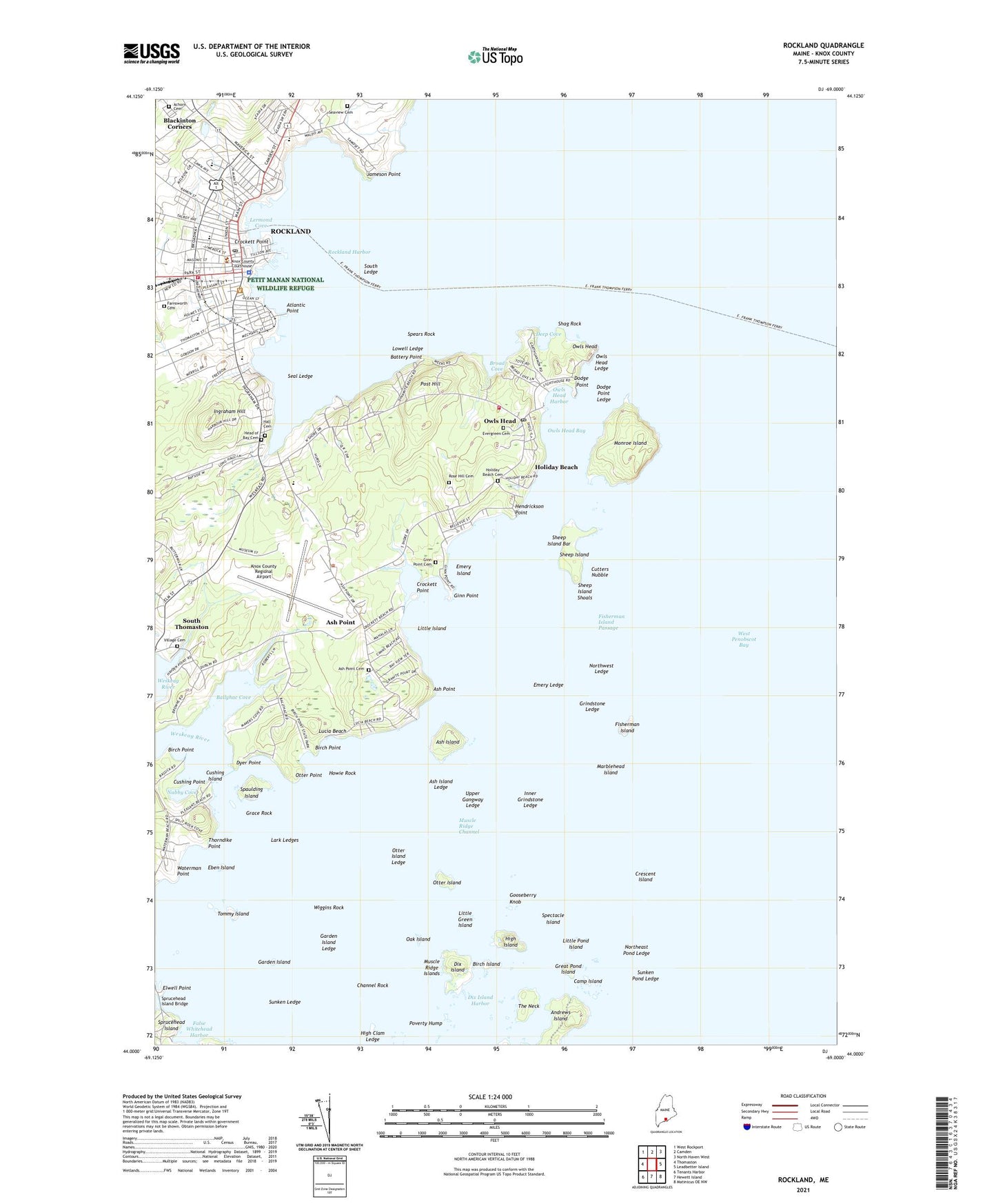
2024 topographic map quadrangle Rockland in the state of Maine. Scale: 1:24000. Based on the newly updated USGS 7.5' US Topo map series, this map is in the following counties: Knox. The map contains contour data, water features, and other items you are used to seeing on USGS maps, but also has updated roads and other features. This is the next generation of topographic maps. Printed on high-quality waterproof paper with UV fade-resistant inks.
Quads adjacent to this one:
West: Thomaston
Northwest: West Rockport
North: Camden
Northeast: North Haven West
East: Leadbetter Island
Southeast: Matinicus OE NW
South: Hewett Island
Southwest: Tenants Harbor
This map covers the same area as the classic USGS quad with code o44069a1.
Contains the following named places: Achorn Cemetery, Ash Island, Ash Island Ledge, Ash Point, Ash Point Cemetery, Ash Point Community School, Atlantic Point, Ballyhac Cove, Bancroft Summer School Camp, Battery Point, Birch Island, Birch Point, Blackinton Corners, Breakwater and Marie Reed Park, Broad Cove, Camp Island, Channel Rock, Clam Ledges, Congregational Church of Rockland, Crescent Beach, Crescent Island, Crockett Point, Cushing Island, Cushing Point, Cutters Nubble, Deep Cove, Dix Island, Dix Island Harbor, Dodge Point, Dodge Point Ledge, Dyer Point, Eben Island, Elwell Point, Emery Island, Emery Ledge, Evergreen Cemetery, False Whitehead Harbor, Farnsworth Cemetery, First Baptist Church, First Unitarian Universalist Church, Fisherman Island, Fisherman Island Passage, Garden Island, Garden Island Ledge, Ginn Point, Ginn Point Cemetery, Gooseberry Knob, Grace Pentecostal Church, Grace Rock, Great Pond Island, Grindstone Ledge, Hall Cemetery, Harbor Park, Head of Bay Cemetery, Hendrickson Point, High Clam Ledge, High Island, High Island Granite Quarry, Holiday Beach, Holiday Beach Cemetery, Howie Rock, Hurricane Island Outward Bound School Dock, Hurricane Island Outward Bound School Headquarters, Ingraham Hill, Inner Grindstone Ledge, J C Park, Jameson Point, Journeys End Marina, Knight Marina, Knox County, Knox County Courthouse, Knox County Law Library, Knox County Regional Airport, Lark Ledges, Lathbury Library, Lermond Cove, Little Green Island, Little Island, Little Pond Island, Littlefield Memorial Baptist Church, Living Waters Revival Church, Lobster Buoy Campsite, Lowell Ledge, Lucia Beach, MacDougal School, Main Street Historic District, Marblehead Island, McLain Middle School, Mid Coast School of Technology, Mid-Coast Mental Health Center, Monroe Island, Muscle Ridge Channel, Muscle Ridge Township, Nabby Cove, Naval Auxiliary Air Station Rockland, North End Shipyard, Northeast Pond Ledge, Northwest Ledge, Oak Island, Oceanside High School, Otter Island, Otter Island Ledge, Otter Point, Owls Head, Owls Head Baptist Church, Owls Head Bay, Owls Head Fire Department, Owls Head Harbor, Owls Head Ledge, Owls Head Light Station, Owls Head Post Office, Owls Head State Park, Owls Head Transportation Museum, Owls Head Transportation Museum Lang Education Center and Library, Owls Head Village Library, Pen Bay Christian School, Pleasant Beach, Post Hill, Poverty Hump, Rockland, Rockland Breakwater, Rockland Breakwater Light, Rockland Chamber of Commerce, Rockland City Hall, Rockland Community Yacht Club, Rockland Department of Public Safety Fire Department, Rockland District Middle School, Rockland Golf Course, Rockland Harbor, Rockland Harbor Boatyard, Rockland Landings Marina, Rockland Plaza Shopping Center, Rockland Police Department, Rockland Post Office, Rockland Public Landing, Rockland Public Library, Rockland Recreation Building and Playground, Rockland Residential Historic District, Rockland Shopping Center, Rockland Visitor Information Center, Rose Hill Cemetery, Saint Bernards Church, Saint Peters Episcopal Church, Samoset Golf Course, Schooner Wharf, Seal Ledge, Seaview Cemetery, Shag Rock, Sheep Island, Sheep Island Bar, Sheep Island Shoals, Shore Village Lighthouse Museum Library, Shore Village Museum, South Ledge, South School, South Thomaston Public Library, Spaulding Island, Spears Rock, Spectacle Island, Sprucehead Island Bridge, Sunken Ledge, Sunken Pond Ledge, The Neck, The Wyeth Center, Thorndike Point, Tommy Island, Town of Owls Head, Unorganized Territory of Muscle Ridge Islands, Upper Gangway Ledge, Village Cemetery, Wasgett Field, Waterman Beach, Waterman Point, Watershed School, Weskeag River, Wiggins Rock, William A Farnsworth Art Museum, William A Farnsworth Homestead, William A Farnsworth Library, WRKD Radio Tower (Havre De Grace), ZIP Code: 04854