MyTopo
Gray Maine US Topo Map
Couldn't load pickup availability
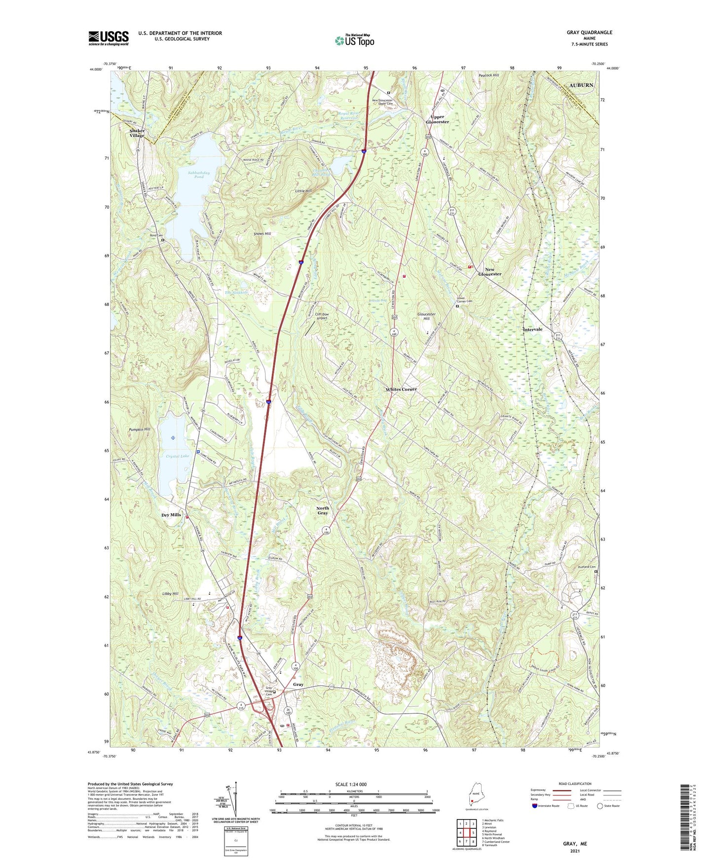
2021 topographic map quadrangle Gray in the state of Maine. Scale: 1:24000. Based on the newly updated USGS 7.5' US Topo map series, this map is in the following counties: Cumberland, Androscoggin. The map contains contour data, water features, and other items you are used to seeing on USGS maps, but also has updated roads and other features. This is the next generation of topographic maps. Printed on high-quality waterproof paper with UV fade-resistant inks.
Quads adjacent to this one:
West: Raymond
Northwest: Mechanic Falls
North: Minot
Northeast: Lewiston
East: North Pownal
Southeast: Yarmouth
South: Cumberland Center
Southwest: North Windham
Contains the following named places: Bear Brook, Brandy Bog, Brandy Brook, Burchard Dunn School, Chandler Mill Pond, Cliff Dow Airport, Cobbs Bridge, Cole Brook, Collyer Brook, Crystal Lake, Dry Mills, Dry Mills Fish Hatchery and Game Farm, Dry Pond Seaplane Base, East Gray, Eddy Brook, Gloucester Hill, Gloucester Hill Lookout Tower, Gray, Gray Census Designated Place, Gray Fire and Rescue, Gray Fire Rescue Department Dry Mills Station, Gray New Gloucester High School, Gray New Gloucester Middle School, Gray Plaza Shopping Center, Gray Public Library, Gray Station, Gray Village Cemetery, Gray Village Fire and Rescue Station 3, Hancock School, Hatchery Brook, Intervale, Jordan Mill Dam, Libby Brook, Libby Hill, Lily Pond Brook, Little Hill, Lower Corner Cemetery, Maine Department of Inland Fisheries and Wildlife Game Farm, Maine State Police Troop B, Meadow Brook, Memorial School, Mill Brook, Mosquito Brook, New Gloucester, New Gloucester Bible Church, New Gloucester Fire and Rescue Department, New Gloucester Fire Department Station 2, New Gloucester Fish Hatchery, New Gloucester Historic District, New Gloucester Public Library, New Gloucester Station, New Gloucester Volunteer Fire Rescue Department, North Gray, Peacock Hill, Pennell Junior High School, Pineland Cemetery, Pineland Hospital and Training Center, Pumpkin Hill, Royal Academy, Royal River Reservoir, Russell School, Sabbathday Pond, Saint Gregory Rectory, Shaker Bog, Shaker Village, Snows Hill, Stevens Brook, The Collaborative School, The Sinkhole, Town of Gray, Town of New Gloucester, United Society of Shakers Sabbathday Lake Library, Universalist Meeting House, Upper Gloucester, Village Fire and Rescue Station, Wayfinder Schools, Westcott Brook, Whites Corner, WTHT-FM (Auburn), WTHT-FM (Lewiston), ZIP Codes: 04039, 04260