MyTopo
Yarmouth Maine US Topo Map
Couldn't load pickup availability
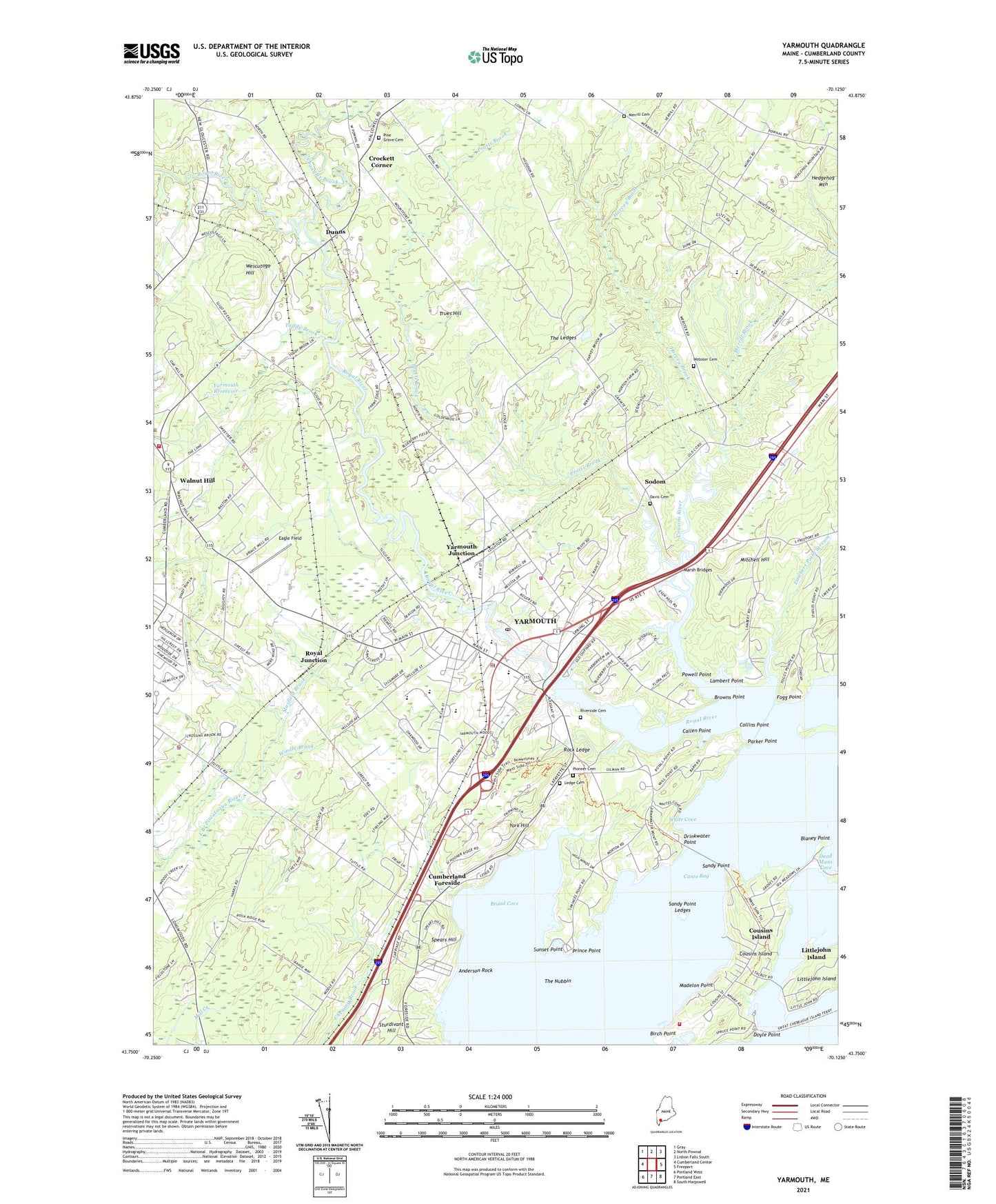
2024 topographic map quadrangle Yarmouth in the state of Maine. Scale: 1:24000. Based on the newly updated USGS 7.5' US Topo map series, this map is in the following counties: Cumberland. The map contains contour data, water features, and other items you are used to seeing on USGS maps, but also has updated roads and other features. This is the next generation of topographic maps. Printed on high-quality waterproof paper with UV fade-resistant inks.
Quads adjacent to this one:
West: Cumberland Center
Northwest: Gray
North: North Pownal
Northeast: Lisbon Falls South
East: Freeport
Southeast: South Harpswell
South: Portland East
Southwest: Portland West
This map covers the same area as the classic USGS quad with code o43070g2.
Contains the following named places: Anderson Rock, Birch Point, Blaney Point, Bridge Street Dam, Broad Cove, Browns Point, Buxton School, Callen Point, Camp Hammond, Chandler Brook, Collins Point, Cousins Island, Cousins Island Census Designated Place, Cousins Island Chapel, Cousins River, Crockett Corner, Cumberland Center Police Department, Cumberland Foreside, Cumberland Rescue Department, Davis Cemetery, Davis Landing, Dead Mans Cove, Desert of Maine, Doyle Point, Drinkwater Point, Dunns, Eagle Field, East Branch Chandler Brook, East Elm Street Dam, Enoch Harrington House Museum, First Baptist Church of Yarmouth, First Parish Congregational Church, First Universalist Church, Fogg Point, Frank Harrison Middle School, Harvey Brook, Hedgehog Mountain, Hodson School, Holy Martyrs Church, Lambert Point, Lambert Point Stream, Lanes Island, Ledge Cemetery, Littlejohn Island, Littlejohn Island Census Designated Place, Lower Village, Madelon Point, Maine Coast Waldorf School, Maine State Information Center, Marsh Bridges, Maxfield Brook, Merrill Brook, Merrill Cemetery, Merrill Memorial Library, Mill Brook, Mitchell Hill, North Yarmouth Academy, North Yarmouth and Freeport Baptist Meetinghouse, North Yarmouth Fire Rescue, North Yarmouth Memorial School, North Yarmouth Post Office, Parker Point, Pine Grove Cemetery, Pioneer Cemetery, Powell Point, Pratts Brook, Prince Point, Riverside Cemetery, Rock Ledge, Roddings Creek, Royal Junction, Royal River, Royal River Park, Royal River Reservoir, Sacred Heart Roman Catholic Church, Saint Judes Church, Saint Mary the Virgin Church, Sandy Point, Sandy Point Ledges, Sodom, Spears Hill, Sturdivant Hill, Sunset Point, The Ledges, The Nubbin, Todds Corners, Toddy Brook, Town House School, Town Landing, Town of Cumberland, Town of North Yarmouth, Town of Yarmouth, Trues Hill, Tuttle Road School, Tuttle Road United Methodist Church, Upper Village, Walnut Hill, Webster Cemetery, Wescutogo Hill, White Cove, Wildwood Park, William Rowe School, Windle Brook, Yarmouth, Yarmouth Academy, Yarmouth Census Designated Place, Yarmouth Elementary School, Yarmouth Fire and Rescue Wyman Station, Yarmouth Fire Rescue, Yarmouth High School, Yarmouth Historical Society and Museum, Yarmouth Junction, Yarmouth Police Department, Yarmouth Post Office, Yarmouth Reservoir, Yarmouth Town Hall, York Hill, ZIP Codes: 04096, 04097