MyTopo
Bristol Maryland US Topo Map
Couldn't load pickup availability
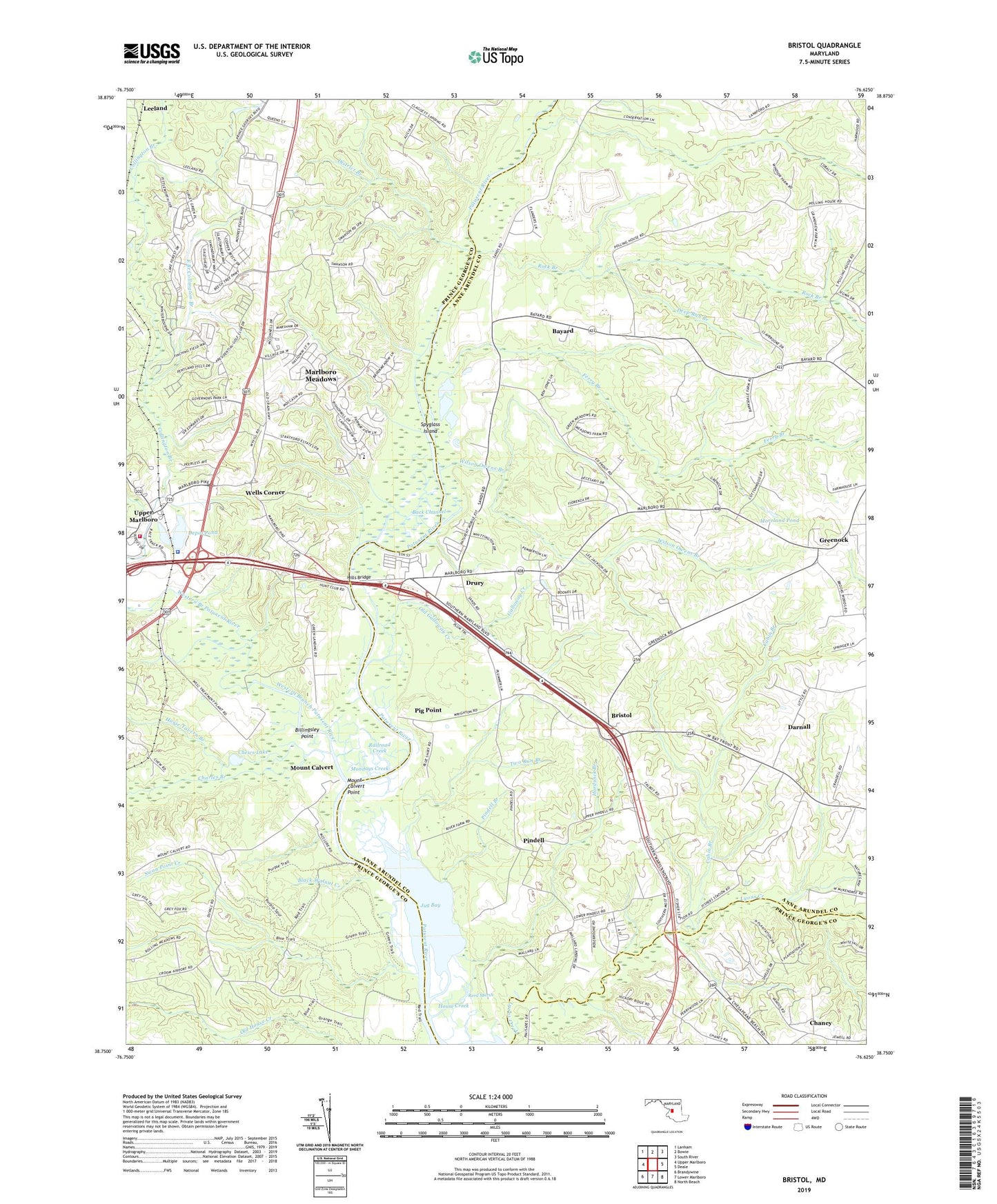
2023 topographic map quadrangle Bristol in the state of Maryland. Scale: 1:24000. Based on the newly updated USGS 7.5' US Topo map series, this map is in the following counties: Anne Arundel, Prince George's, Calvert. The map contains contour data, water features, and other items you are used to seeing on USGS maps, but also has updated roads and other features. This is the next generation of topographic maps. Printed on high-quality waterproof paper with UV fade-resistant inks.
Quads adjacent to this one:
West: Upper Marlboro
Northwest: Lanham
North: Bowie
Northeast: South River
East: Deale
Southeast: North Beach
South: Lower Marlboro
Southwest: Brandywine
This map covers the same area as the classic USGS quad with code o38076g6.
Contains the following named places: Adams Church, Am - Van Ambulance and Transport, Back Channel, Barksdale Farms, Bayard, Bethel United Methodist Church, Billingsley Point, Black Walnut Creek, Blue Ridge Farms, Boones Mobile Estates, Bristol, Bristol Landing, Bristol School, Brock Hall Census Designated Place, Brookridge School, Cabin Branch, Calvert Estates, Century Manor, Chaney, Chaney Station, Charles Branch, Chews Lake, Collington Branch, Conte Manor, Courtney Manor, Croom Acres, Croom High School, Croom Vocational School, Darnall, Deep Creek, Deep Run Branch, Depot Pond, District 3 Marlboro, District Branch, Drury, Dunleigh, East Branch Collington Branch, Federal Spring Branch, Ferry Branch, Fox Chapel, Galloway Creek, Greater Upper Marlboro Census Designated Place, Green Landing, Greenock, Hardwick Branch, Hawthorne Woods, Heritage Hills, Hills Bridge, Horse Tavern Branch, House Creek, Hunt Chapel, Hunt Valley Estates, Iron Pot Landing, Jackson Landing, Jug Bay, Jug Bay Wetlands Sanctuary, Lahaina, Leeland, Lothian Estates, Lothian Post Office, Lothian Woods, Lyons Creek Fischers, Lyons Creek Hundred, Lyons Creek Mobile Estates, Marlboro Fire Station Company 20, Marlboro Heliport, Marlboro Horse Farm, Marlboro Hunt Club, Marlboro Meadows, Marlboro Meadows Census Designated Place, Marlboro Speedway, Marlboro Square Shopping Center, Marlboro Station, Marlboro Volunteer Fire Department Station 820, Mary E White Estate, Maryland Mobile Estates, Mill Creek, Mondays Creek, Moreland Pond, Mount Calvary Methodist Church, Mount Calvert, Mount Calvert Point, Old Galloway Creek, Old South Country Club, Patuxent Elementary School, Patuxent Mobile Estates, Pennsylvania Junction, Peters Chapel, Pig Point, Pigg Point, Pindell, Pindell Branch, Pond View Acres, Portland Manor, Prince George's County Equestrian Center, Prince George's County Sheriff's Office, Railroad Creek, Reed Marsh, Reo Vista Plaza, Rio Vista Plaza Mobile Home Park, Rock Branch, Route 260 Recreation Area, Rustic Knolls, Saint Lukes Chapel, Saint Mary of the Assumption Catholic Church, Saint Marys of the Assumption School, Selbys Landing, Sollers United Methodist Church, Springfield, Spyglass Island, Swan Point Creek, Thanksgiving Farm, The Sands, Twin Shields Estates, Twin Shields Golf Course, Two Run Branch, Upper Marlboro, Upper Marlboro Courthouse, Upper Marlboro Town Hall, Vale of Pleasure Horse Farm, Waysons Corner, Waysons Mobile Court, Wells Corner, Wesley Chapel, Western Branch Patuxent River, Wilson Owens Branch, Winding Brooke, Windsor Farm, ZIP Code: 20711