MyTopo
Damascus Maryland US Topo Map
Couldn't load pickup availability
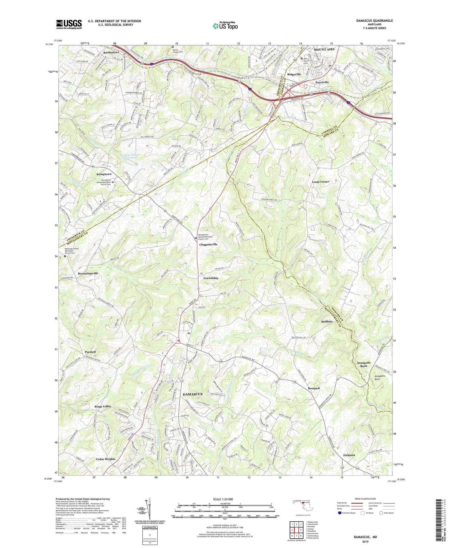
2019 topographic map quadrangle Damascus in the state of Maryland. Scale: 1:24000. Based on the newly updated USGS 7.5' US Topo map series, this map is in the following counties: Montgomery, Frederick, Howard, Carroll. The map contains contour data, water features, and other items you are used to seeing on USGS maps, but also has updated roads and other features. This is the next generation of topographic maps. Printed on high-quality waterproof paper with UV fade-resistant inks.
Quads adjacent to this one:
West: Urbana
Northwest: Walkersville
North: Libertytown
Northeast: Winfield
East: Woodbine
Southeast: Sandy Spring
South: Gaithersburg
Southwest: Germantown
Contains the following named places: Annapolis Rock, Ashley Acres, Bartholows, Bennett Manor, Bethesda United Methodist Church, Bethesda United Methodist Church Cemetery, Bicentennial Estates, Bootjack, Bradford Estates, Browningsville, Carroll County Public Library - Mount Airy Branch, Cedar Grove Knolls, Cedar Heights, Cedar Heights Estates, Chesney, Claggettsville, Clearspring Elementary School, Clearspring Manor, Cold Hill Academy, Conestoga Heights, Country View, County View, Damascus, Damascus Census Designated Place, Damascus Church of God, Damascus Elementary School, Damascus Gardens, Damascus High School, Damascus Hill, Damascus Library, Damascus Manor, Damascus Park, Damascus Post Office, Damascus Seventh Day Adventist Church, Damascus Shopping Center, Damascus Terrace, Damascus United Methodist Church, Damascus Valley Estates, Damascus Valley Park, Damascus View, Damascus Volunteer Fire Department - Station 13, Damascus Wesleyan Church, Davis, Dendor Mar Estates, Diamond View, District 12, Duvall Manor, East Rolling Hills, Engleside Farm, Etchison, Faith Tabernacle Assembly of God, Farmfield Estates, First Baptist Church, Florence Estates, Four County Farm, Fox Ridge Estates, Fremont Acres, Friendship, Friendship Knolls, Great Seneca Stream Valley Park Unit 9, Green Valley Census Designated Place, Greenhills, Hanford Estates, Harmans/Dorsey Fire Station Company 21, Harmony Hall, Harvest Ridge, Hawthorne Acres, Hickory Hill, Hickory Ridge, Highview, Howard Chapel Methodist Church, Hungerford Manor, Janwood, John Haines Park, John T Baker Middle School, Kelly Ridge, Kempton Community Park, Kemptown, Kemptown Elementary School, Killara Farm, Kings Valley, Kings Valley Manor, Kingstead Knolls, Kittyhawk Estates, Langdon Woods, Linganore View, Lois P Rockwell Elementary School, Long Corner, Marvin Chapel Cemetery, Marvin Chapel Methodist Church, Merridale, Merridale Gardens, Mid Country View, Mill Bottom, Molesworth Hills, Montgomery Methodist Children's Center, Montgomery United Methodist Church, Montgomery United Methodist Church Cemetery, Mount Airy Carnival Grounds, Mount Airy Industrial Park, Mount Airy Methodist Church, Mount Airy Post Office, Mount Airy Shopping Center, Mount Airy Wastewater Treatment Plant, Mount Lebanon, Mount Radnor Heights, Mount Tabor United Methodist Church, Mountain View United Methodist Church, Moyer Road Park, Mullinix, Oak Ridge Conservation Park, Park Lake Estates, Park View Estates, Parrsville, Pheasant Ridge Mobile Estates, Pine Grove Cemetery, Pine Grove Presbyterian Church, Pleasant Grove Community Church, Poulsen Heights, Providence United Methodist Church, Providence United Methodist Church Cemetery, Purdum, Rattle Ridge, Rattlewood Golf Course, Redeemer Lutheran Church, Ridgeside Business Center, Ridgeville, Ridgeville United Methodist Church, Rock Hill Orchard, Rolling Hills, Ronalee Hills, Rosswood Estates, Saint Annes Episcopal Church, Saint Clair Farm Pond, Saint Clair Farm Pond Dam, Saint Paul Catholic Church, Samhill Estates, School Number 15, Scott Branch, Seneca Overlook, Seneca Springs, Shaffers Mill Estates, Silver Crest, Silver Maple Estates, Skyline Manor, Skyline Woods, Smith Village, Southview, Sparr Spring, Spring Garden Estates, Stonelake, Sugarloaf Overlook, Sundown Manor, Sweepstakes, The Wesleyan Church, Tolley Terrace, Town of Mount Airy, Treasure Mountain, Tri-County Baptist Church, Twin Arch Business Park, Twin Arch Industrial Park, Twin Arch Shopping Center, Twin Ridge Elementary School, Upper Magruder Branch Park, Upper Seneca Crest, Village of Tall Oaks, West Oak Fields, Wolf Den Spring, Woodfield Elementary School, ZIP Code: 20872