MyTopo
Winfield Maryland US Topo Map
Couldn't load pickup availability
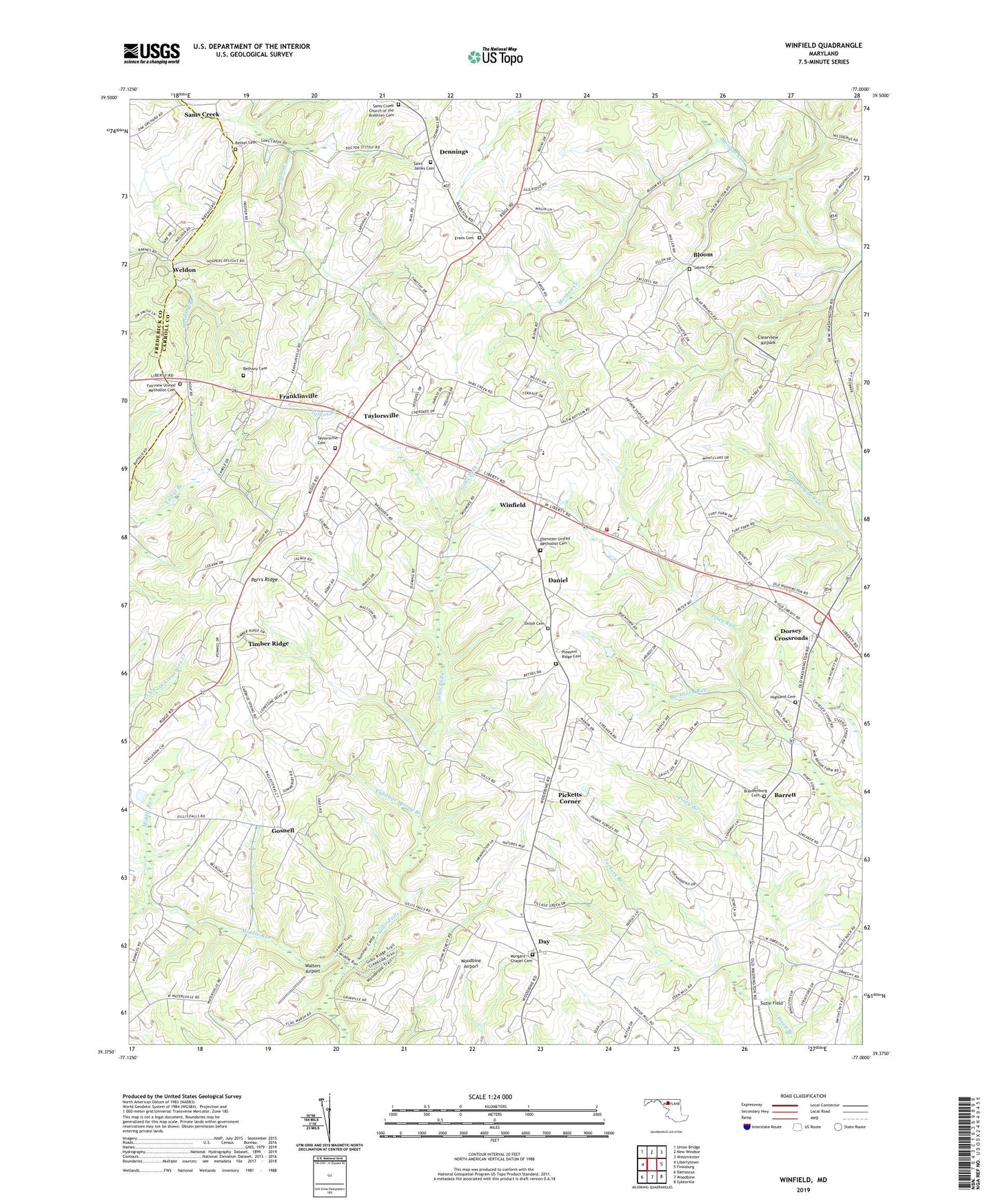
2023 topographic map quadrangle Winfield in the state of Maryland. Scale: 1:24000. Based on the newly updated USGS 7.5' US Topo map series, this map is in the following counties: Carroll, Frederick. The map contains contour data, water features, and other items you are used to seeing on USGS maps, but also has updated roads and other features. This is the next generation of topographic maps. Printed on high-quality waterproof paper with UV fade-resistant inks.
Quads adjacent to this one:
West: Libertytown
Northwest: Union Bridge
North: New Windsor
Northeast: Westminster
East: Finksburg
Southeast: Sykesville
South: Woodbine
Southwest: Damascus
This map covers the same area as the classic USGS quad with code o39077d1.
Contains the following named places: Academy Acres, Airport Acres, Anne Arundel County Fire Department 31, Arthur Ridge, Ashley Mobile Home Park, Atkins Acres, Baltimore City Fire Department, Barrett, Belmar Estates, Benders Heights, Bethany Cemetery, Bethany Methodist Church, Bethel Cemetery, Bethel United Methodist Church, Blankner Hill, Bloom, Braddock Estates, Braddock Manor West, Brandenburg United Methodist Church, Brandenburg United Methodist Church Cemetery, Buckhorn Run, Buffalo Estates, Buffalo Hills, Bushey Heights, Cabbage Spring Branch, Calvary Church, Camp Fartherest Out, Carroll County Fire Department Station 14 Winfield Volunteer Fire Department, Carroll Woods Estates, Chases Forest, Chestnut Oaks, Clearview Airpark, Covers Corner, Cumorah Estates, Daisy Meadows, Dales Delight, Daniel, Day, Dennings, District 13 Mount Airy, District 14 Berrett, District 9 Franklin, Dogwood Estates, Dorsey Crossroads, Dorsey Hill, Dotsons Ridge, Dream Catcher Farm, Dulany Hills, Eagle Wood Estates, Ebenezer United Methodist Cemetery, Ebenezer United Methodist Church, Elbeekay Farms, Equestrian Estates, Evans Cemetery, Fair View United Methodist Church, Fairview United Methodist Cemetery, Fischer, Fleming Way Estates, Flowerwood Estates, Franklinville, Gasnell Estates, Gilboa, Gillis Falls Estates, Glenvue Acres, Golden Age Nursing Home, Gosnell, Grahams Green Acres, Hazels Woods, Heather Ridge, Heritage, Highland View Cemetery, Huntfield, Ivy Hill Way, Kimberly Heights, Latigo Trails, Legos Choice, Links at Challedon, Manahan, Mayeski Park, McHenry Meadows, Messiah Evangelical Lutheran Church, Middle Run, Monks Misery, Montclare, Morgan Chapel United Methodist Church, Morgan Creek, Morgans Chapel Cemetery, Mount Airy Mennonite School, Mountain Vista, New Horizons, New Venture Estates, Oceola Estates, Olde Oak Run, Olde Washington Valley, Parrs Ridge, Picketts Corner, Piney Run Estates, Pleasant Ridge Cemetery, Poignant Acres, Quail Creek Acres, Raydan Retreat, Ray-Mar Estates, Red Fox Meadow, Ritter, River Wood Hills, Rolling Carroll Estates, Rolling Hills, Saint James Cemetery, Saint James United Methodist Church, Salem Cemetery, Salem United Methodist Church, Salt Box Park, Sams Creek, Sams Creek Church of the Brethren, Sams Creek Church of the Brethren Cemetery, Sanner Estates, Serpent Ridge Vineyard, Shawns Landing, Shiloh Cemetery, Snells Nursery, South Carroll Estates, South Carroll High School, Stanton Heights, Stone House Village, Stoney Ridge, Streamwood, Sun Valley, Sun Valley Farms, Suzie Field, Tarson Manor, Taylorsville, Taylorsville Cemetery, Taylorsville United Methodist Church, Timber Ridge, Timbermead, Tuckers Branch, Valley Hill Farms, Villa Tomarchio, Village Green Estates, Walters Airport, Watersville Acres, Weldon, White Rock, White Turf Farm, Wild Lake Estates, Winfield, Winfield Bible Chapel, Winfield Elementary School, Winfield Heights, Winfield Woods, Woodbine Acres, Woodbine Airport, Woodbine School, Woodbridge