
MyTopo
Edgewood Maryland US Topo Map
Couldn't load pickup availability
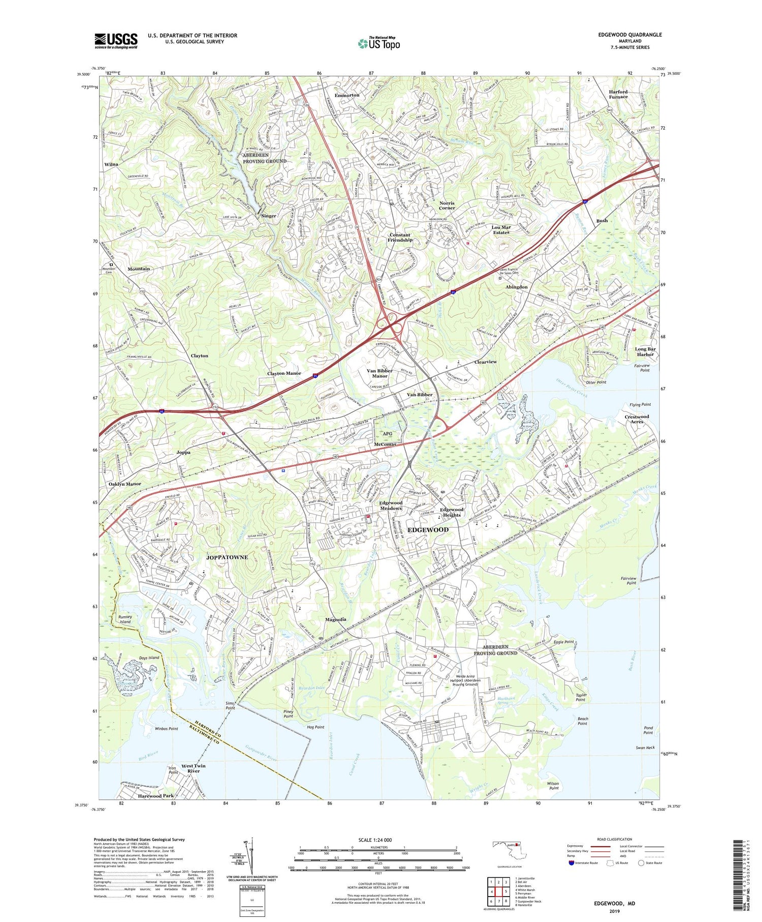
2019 topographic map quadrangle Edgewood in the state of Maryland. Scale: 1:24000. Based on the newly updated USGS 7.5' US Topo map series, this map is in the following counties: Harford, Baltimore. The map contains contour data, water features, and other items you are used to seeing on USGS maps, but also has updated roads and other features. This is the next generation of topographic maps. Printed on high-quality waterproof paper with UV fade-resistant inks.
Quads adjacent to this one:
West: White Marsh
Northwest: Jarrettsville
North: Bel Air
Northeast: Aberdeen
East: Perryman
Southeast: Hanesville
South: Gunpowder Neck
Southwest: Middle River
Contains the following named places: Abingdon, Abingdon Census Designated Place, Abingdon Elementary School, Abingdon Landfill, Abingdon Post Office, Abingdon Reserve, Ames Shopping Center, Annes Delight, Ashby Place, Atkisson Dam, Atkisson Reservoir, Beach Point, Beechwood Mobile Home Park, Bird River, Blackhawk Spring, Box Hill North, Box Hill South, Box Hill Square Shopping Center, Bradford Barrens, Bren-Mar Golf Course, Brierwood, Broadview, Bush, Bush Declaration Natural Resources Management Area, Bynum Hills, Bynum Overlook, Bynum Run, Bynum Run Conservation Area, Canal Creek, Cat Creek, Chesapeake Christian School, Claggerts Forest, Clayton, Clayton Manor, Clayton Road Park, Clayton Station Business Center, Clearview, Cochran Hills, Constant Branch, Constant Friendship, Constant Friendship Park, Constant Friendship Shopping Center, Copenhaver Park, Country Walk, Courts of Harford Square, Crestwood Acres, Crisfield Crossing, Days Cove, Days Island, Deerfield Elementary School, District 1 Abingdon, Eagle Point, East Branch Canal Creek, Eastern Christian College, Edgewater Park, Edgewater Village, Edgewater Village Dam, Edgewater Village Lake, Edgewater Village Shopping Center, Edgewood, Edgewood Area Health Clinic, Edgewood Census Designated Place, Edgewood Elementary School, Edgewood Heights, Edgewood High School, Edgewood Meadows, Edgewood Middle School, Edgewood Park, Edgewood Plaza Shopping Center, Edgewood Post Office, Edgewood Proving Ground, Edgewood Square Shopping Center, Emmord Branch, Emmorton, Emmorton Business Park, Emmorton Elementary School, Fairview Point, Festival at Bel Air Shopping Center, Flying Point, Flying Point Marina, Flying Point Park, Fort Hoyle, Foster Branch, Frey Landing, Fritz Farm and Nursery, Greater Harford Industrial Park, Green Acres, Green Springs Hills, Gunpowder Falls, Gunpowder Point Park, Gunpowder Post Office, Haha Branch, Happy Acres, Harbour Oaks, Harewood Park, Harford Boat Club, Harford Commons, Harford Furnace, Harford Furnace Historic District, Harford Glen Park, Harford Landing, Harford Manor, Harford Mobile Village, Harford Square, High Bridge Branch, Hog Point, Holman Manor, Hunters Run, Iron Point, Ivy Hill, James Run, Johnson Manor, Joppa, Joppa Acres, Joppa Landing, Joppa Post Office, Joppatowne, Joppatowne Census Designated Place, Joppatowne Elementary School, Joppatowne High School, Joppatowne Plaza Shopping Center, Joppatowne Wastewater Treatment Plant, Kenwood Farm Estates, Kiddie Academy International, Kiddie Academy of Golden Ring, Kings Creek, Lauderick Creek, Laurel Valley, Laurel Woods, Leight Park, Little Gunpowder Falls, Long Bar Harbor, Lou Mar Estates, Magnolia, Magnolia Elementary School, Magnolia Estates Mobile Home Park, Magnolia Middle School, Magnolia Post Office, Martin Manor, McComas, McComas Institute, McGuigan Park, Meadowood, Millwood, Monks Creek, Mount Bush Estates, Mountain, Mountain Branch, Mountain Branch Golf Course, Mountain Cemetery, Mountain Christian School, Mountain Road Park, Mountain View Estates, New Covenant Christian School, Nike Site BA-18C, Nike Site BA-18L, Norris Corner, Oaks of Harford, Open Acres Manor, Osborns Ruins, Otter Creek Marina, Otter Point, Overview Manor, Pembrook, Perry's Mobile Home Park, Philadelphia Gunning Club, Philadelphia Station, Piney Point, Plumtree Estates, Plumtree Run, Pond Point, Railroad Creek, Rams Creek, Reardon Branch, Reardon Inlet, Redman Cove, Reeds at Bayview Mobile Home Park, Rivershore, Riverside Elementary School, Rock Jetty, Royal Heights, Rumsey Island, Saint Francis De Sales Cemetery, Scholar Woods, Sewell Station, Shannon Heath, Sims Point, Singer, Singer Road Park, Singer Woods, Stockton Green, Stoneleigh Square, Tapler Point, Temple Hills, The Cedars, The Pointe, The Timbers, Trimble Fields, Trinity Lutheran School, Twin Brook Estates, Valley View, Van Bibber, Van Bibber Manor, Village of Bynum Run, Village of Church Creek, Weide Army Heliport (Aberdeen Proving Ground), West Shore, West Twin River, Westwood Range, Wheel, White Oak Crest, William Longley Park, William Paca - Old Post Road Elementary School, William Paca Industrial Park, William S James Elementary School, Williams Mobile Home Park, Willoughby Court, Willoughby Woods, Wilna, Wilson Point, Winbos Point, Winters Run, Winters Run Conservation Area, Winters Run Industrial Park, Winters Run Park, Woodale Homes, Woodbridge Center, Woodland Run, Woodlea, Woodsdale, Woodsdale Meadows, ZIP Codes: 21009, 21010, 21040, 21085


