MyTopo
Jarrettsville Maryland US Topo Map
Couldn't load pickup availability
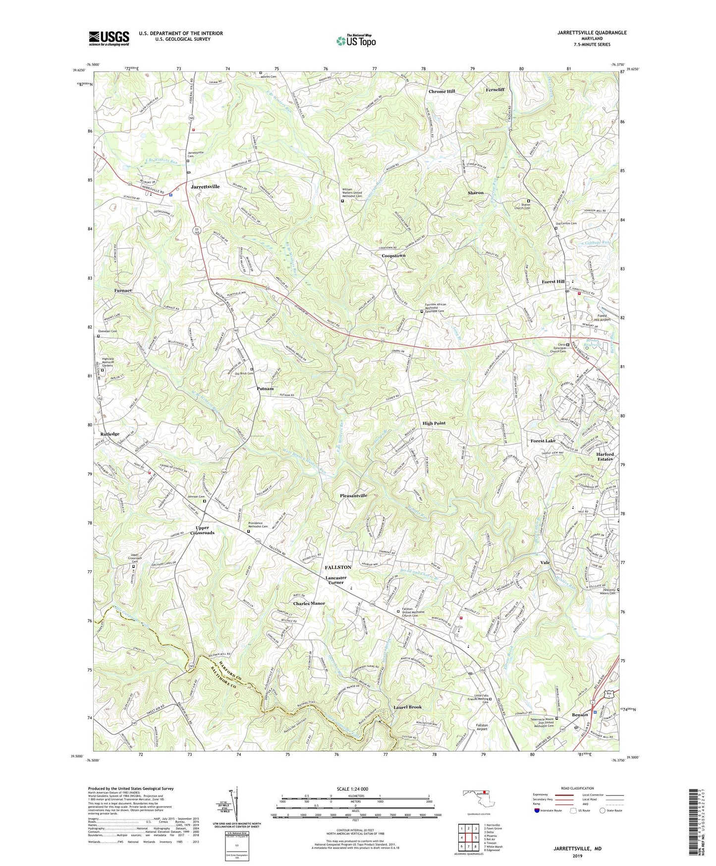
2023 topographic map quadrangle Jarrettsville in the state of Maryland. Scale: 1:24000. Based on the newly updated USGS 7.5' US Topo map series, this map is in the following counties: Harford, Baltimore. The map contains contour data, water features, and other items you are used to seeing on USGS maps, but also has updated roads and other features. This is the next generation of topographic maps. Printed on high-quality waterproof paper with UV fade-resistant inks.
Quads adjacent to this one:
West: Phoenix
Northwest: Norrisville
North: Fawn Grove
Northeast: Delta
East: Bel Air
Southeast: Edgewood
South: White Marsh
Southwest: Towson
This map covers the same area as the classic USGS quad with code o39076e4.
Contains the following named places: Advocate Hill Farms, Amoss, Bakersfield, Baldwin Hills, Baldwin Mill Terrace, Baptist View Church, Bear Cabin Branch, Beetree Farms Nursery, Bel Air Reservoir, Bel Air Volunteer Fire Company Forest Hill Station, Bel Forest, Bel Forest Christian Academy, Belle Meade, Bellvale, Belvedere Farm, Benson, Benson Post Office, Brandywine Farms, Bread and Cheese Branch, Briar Ridge, Brook Hill Farms, Carroll Meadows, Cedarwood, Centre United Methodist Church, Chadwick, Charles Manor, Christ Episcopal Church Cemetery, Chrome Hill, Clear Spring Estates, Clover Field, Cloverdale, Coopstown, Cougar Brook, Cross Country Estates, Cross Roads Station Shopping Center, Crystal Spring Farm, Dulaney Ridge, Eagle View, East Branch Winters Run, Ebenezer Cemetery, Ebenezer Church, Elbow Brook, Fairview, Fairview African Methodist Episcopal Cemetery, Fairview Church, Falls Crest, Fallsmont, Fallston, Fallston Airport, Fallston Census Designated Place, Fallston High School, Fallston Middle School, Fallston Post Office, Fallston Recreation Complex, Fallston United Methodist Church Cemetery, Fallston United Presbyterian Church, Fallston Volunteer Fire and Ambulance Company House 1, Fallston Volunteer Fire and Ambulance Company House 2, Fallston-Jarrettsville Branch Harford County Library, Ferncliff, Forest Hill, Forest Hill Business Center, Forest Hill Elementary School, Forest Hill Post Office, Forest Hill Recreation Complex, Forest Lake, Forest Lakes Elementary School, Forest Ridge Baptist Church, Franklins Chance, Friends Church, Friends Park, Friendship Church, Furnace, Grafton Shops, Grandview Church, Grandview Methodist Church, Green Road Manor, Green Valley, Greendale Estates, Greenfields, Gunpowder Farms, Haddon Hurst, Harford County Public Library - Jarrettsville Branch, Harford County Sheriff's Office Northern Precinct, Harford Downs, Harford Estates, Harford Hunt Manor, Harford Vineyard, Harvest Hills, Hazelwood, Heavenly Waters Cemetery, Hidden Valley, High Point, High Point Estates, High Point Manor, Highfield Park, Highview Estates, Highview Memorial Gardens, Holy Communication Lutheran Church, Hoops Branch, Hunting Ridge, Huntington, Hy-Crest, James Run Christian Academy, Jarrettsville, Jarrettsville Cemetery, Jarrettsville Census Designated Place, Jarrettsville Elementary School, Jarrettsville Plaza Shopping Center, Jarrettsville Post Office, Jarrettsville Recreation Complex, Jarrettsville United Methodist Church, Jarrettsville Volunteer Fire Company Main Station, Jarrettswood, Johnson Cemetery, Klein, Lancaster Corner, Laurel Brook, Little Falls Friends Meeting Cemetery, Long Branch, Long Green Manor, Maryland Aquatic Nurseries, Maryland State Police - Barrack D Bel Air, Montford Glen, Moores Cemetery, North Stirrup Run, Oakmont, Old Brick Cemetery, Old Brick Church, Old Centre Cemetery, Orchard Lakes, Overshot Branch, Parkshire, Parkwood, Parliament Ridge, Perry Hall Estates, Pinehurst, Pleasant Valley Farms, Pleasant View Farms, Pleasantville, Powder Mill Addition, Providence Church, Providence Methodist Cemetery, Putnam, Putnam Hill, Putnam View Estates, Putnam Village, Quiet Inheritance, Ridgecroft, Ridgeview, Rochelle Meadows, Rock Acres, Rock Spring, Rock Spring Church, Rock Spring Village Assisted Living Center, Rock Springs Swim Club, Rockdale Manor, Round Acres, Rutledge, Saint Marks Church, Salem Lutheran Church, Scarff, Seven Cedars, Sharon, Sharon Acres, Sharon Church, Sharon Church Cemetery, Sharon Hill, South Stirrup Run, Spring Hill Farms, Springdale, Springwood Farms, Steeplechase Manor, Stirrup Run, Strathmore, Tabernacle Church, Tabernacle Mount Zion United Methodist Cemetery, Tall Oak Manor, The Pond, Timberlea, Union Church, Upper Crossroads, Upper Crossroads Cemetery, Upper Crossroads Church, Vale, Vale Hills, Valewood Estates, Village Manor, Wales of Harford, Watters Church, West Branch Winters Run, Whitakers Mill Historic District, White House Park, WHRF-AM (Bel Air), Wildwood, William Watters United Methodist Cemetery, Willows, Wimbledon, Winters Run, Winters Run Golf Course, Woodfield, Woodridge Manor, Woodsbrook, Youth's Benefit Elementary School, ZIP Codes: 21013, 21047, 21050, 21084