MyTopo
Rising Sun Maryland US Topo Map
Couldn't load pickup availability
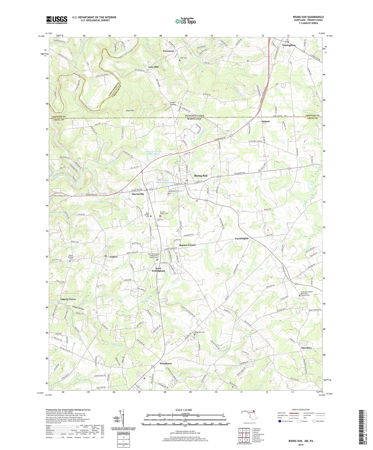
2019 topographic map quadrangle Rising Sun in the states of Maryland, Pennsylvania. Scale: 1:24000. Based on the newly updated USGS 7.5' US Topo map series, this map is in the following counties: Cecil, Chester, Lancaster. The map contains contour data, water features, and other items you are used to seeing on USGS maps, but also has updated roads and other features. This is the next generation of topographic maps. Printed on high-quality waterproof paper with UV fade-resistant inks.
Quads adjacent to this one:
West: Conowingo Dam
Northwest: Wakefield
North: Kirkwood
Northeast: Oxford
East: Bay View
Southeast: North East
South: Havre De Grace
Southwest: Aberdeen
Contains the following named places: Albeck Farms, Barnes Corner, Birmingham School, Blacks School, Brookview Cemetery, Brookview Chapel, Browns School, Buller School, Calvary Church, Calvary Missionary Baptist Church, Camp Horseshoe, Cathers Corner, Cecil Community Center, Cecil County Emergency Medical Services Paramedic Station 1, Chelsea of Nottingham, Cherry Grove School, Clearview, College Green, Colony Acres, Colora, Colora Meetinghouse, Colora Orchard, Colora Post Office, Community Fire Company of Rising Sun Station 8, Cooper School, Country Acres, Curtis Acres, Diddie Richardson Park, District 6 Rising Sun, Dove Valley Winery, Ebenezer Church, Ebenezer United Methodist Church Cemetery, Farmington, Farmington Airport, Farmington Post Office, Frank, Freemont, Friends School House, Goat Hill, Goat Hill Barrens, Greenfield Acres, Greenhurst, Harrisville, Highlands - Running Brook Mobile Home Park, Hillview Farms, Hog Run, Holland Acres, Honeysuckle Hollow, Hopewell Church, Hopewell Manor, Jackson Mill Farms, Janes Methodist Church, Jefferson School, Kincaid Farm, Krauss Family Cemetery, Lees Bridge, Lees Mill, Liberty Grove, Liberty Grove School House, Little Brick Friends Meetinghouse, Loves Run School, Lynch's Landing, Maple Hill Mobile Home Park, Marion School, Mason Dixon Village, Meadows Farm, Mount Hope Church, Mount Pleasant Acres, Mount Pleasant Cemetery, Mount Pleasant Church, Mount Pleasant Manor, Mount Pleasant View, Nesbitt Run, New Bridge Cemetery, New Bridge Church, North Hills, Nottingham, Nottingham Barrens, Nottingham Fields, Nottingham Park, Oak Grove, Oak Grove School, Octararo, Octararo Forge, Octararo Lakes, Orchard View, Orrs Acres, Oxford Airport, Pleasant View, Plumpton Park Zoological Gardens, Port Heights, Principio, Principio Heights, Principio Post Office, Proctors Seat, Pumpton County Park, Reynolds Run, Richards Oak, Richardson Park, Rising Sun, Rising Sun Branch Cecil County Public Library, Rising Sun Church of God, Rising Sun Community Pond, Rising Sun Elementary School, Rising Sun High School, Rising Sun Plaza Shopping Center, Rising Sun Police Department, Rising Sun Post Office, Rising Sun School, Rising Sun Town Hall, Rising Sun Waste Water Lagoon, Rising Sun Waste Water Lagoon Dam, Rocky Top Church, Rumbleway Farm, Sharon Run, Spring Meadow, Stone Run, Stone School House, Stubbs Hill Regional Park, Sunrise Estates, Sunset Gardens, Sunset Knoll, Sunview, Sweet Grass Meadow, Sylmar, Theodore, Timber Grove Mobile Home Park, Tome Estates, Tosh Farms, Town of Rising Sun, Township of West Nottingham, Union Cemetery, Union Church, Union Fire Company 1 Nottingham Station 21, Vinegar Hill, Waibelwood Park, Water Witch Fire Company Station 72, West Nottingham, West Nottingham Academy, West Nottingham Academy Historic District, West Nottingham Presbyterian Church, West Nottingham Presbyterian Church Cemetery, West Nottingham Township Police Department, William Penn State Forest, Winchester Village, Wood Chromite Mine, Woodlawn, Woodlawn Cemetery, Woodlawn Mobile Home Estates, Woodlawn Post Office, Woodlyn Heights, Wooldlawn Heights, ZIP Codes: 21911, 21917