MyTopo
Upper Marlboro Maryland US Topo Map
Couldn't load pickup availability
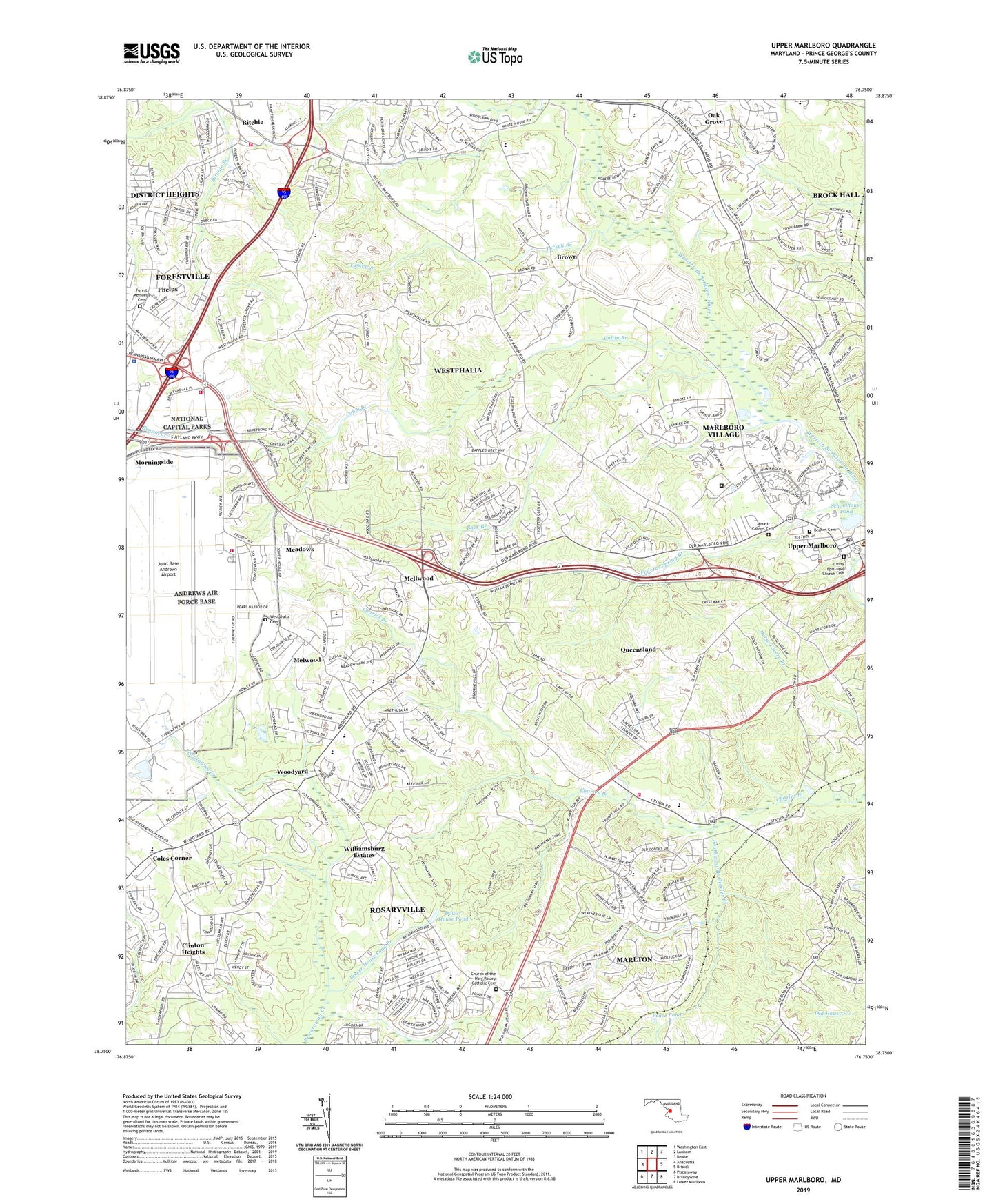
2019 topographic map quadrangle Upper Marlboro in the state of Maryland. Scale: 1:24000. Based on the newly updated USGS 7.5' US Topo map series, this map is in the following counties: Prince George's. The map contains contour data, water features, and other items you are used to seeing on USGS maps, but also has updated roads and other features. This is the next generation of topographic maps. Printed on high-quality waterproof paper with UV fade-resistant inks.
Quads adjacent to this one:
West: Anacostia
Northwest: Washington East
North: Lanham
Northeast: Bowie
East: Bristol
Southeast: Lower Marlboro
South: Brandywine
Southwest: Piscataway
Contains the following named places: Amazing Grace Baptist Church, Andrews Air Force Base Census Designated Place, Apostolic Christian Church, Arrowhead Elementary School, Back Branch, Barack Obama Elementary School, Beanes Cemetery, Berry Lane, Bladensburg Baptist Church, Brandywine County, Brock Hall, Brookridge Manor, Brookwood, Brown, Brown School, Brown Station Census Designated Place, Brown Station Road Landfill, Cabin Branch, Camp Springs Community Church, Charles Branch Stream Valley Park, Cheltenham Woods Community Park, Chester Grove, Church of the Holy Rosary, Church of the Holy Rosary Catholic Cemetery, Church of the Way, Clinton Christian School, Clinton Heights, Coles Corner, Croom, Croom Station, D'Arcy Hills, District 15 Mellwood, Divine Peace Elementary School, Divine Peace Lutheran Church, Doctor Henry A Wise Junior High School, Douglass School, Dower House Pond, Dower House Pond Branch, Fairgreen, Federal Law Enforcement Training Center, Federal Spring Recreation Center, Fellowship Baptist Church, Fernwood Mobile Home Park, First Baptist Church, Flower Village Mobile Home Park, Flying Change Farm, Forest Memorial Cemetery, Forest Memorial United Methodist Church, Forestville, Forestville Baptist Church, Forestville Census Designated Place, Forestville Fire Station Company 23, Forestville Free Methodist Church, Forestville Plaza Shopping Center, Forestville School, Forestville Volunteer Fire Department Station 823, Frederick Douglass High School, Frederick Sasscer High School, Greenwood Manor, Greenwood Manor Community Park, H Winship Wheatley Early Childhood Center, His Lordship's Kindness Horse Farm, Hollaway Estates, Holloway Estates Park, Imagine Foundations at Leeland School, James Madison Middle School, Jerusalem African Methodist Episcopal Church, Joint Base Andrews Airport, Joint Base Andrews Fire Station 2, Kingdom Christian Academy Elementary School, Kingdom Hall of Jehovahs Witnesses Forestville Congregation, Linton Hall, Little Washington, Little Washington Neighborhood Park, Marlboro Branch Prince George's County Memorial Library, Marlboro Country Club, Marlboro Village Census Designated Place, Marlboro Volunteer Fire Department Station 845, Marlton, Marlton Census Designated Place, Marlton Community Park, Marlton Elementary School, Marlton Golf Club, Marlton Neighborhood Park, Marlton Plaza Shopping Center, Maryland State Police Department Barrack L, Maryvale, Meadows, Mellwood, Mellwood Church of the Nazarene, Mellwood Hills Community Park, Mellwood Park, Mellwood Pond Community Park, Melwood Census Designated Place, Melwood Elementary School, Melwood Mall Shopping Center, Melwood Mobile Home Park, Mount Carmel Cemetery, Norbourne Mobile Home Park, North Forestville Elementary School, North Roblee Acres, Oak Grove, Oak Grove Substation, Osborne Shopping Center, Our Saviours School, Pence Pond, Penn-Belt South Industrial Park, Penn-East Business Park, Phelps, Piscataway Creek Park, Presidential Corporate Center, Prince George's County, Prince George's County Correctional Center, Public Documents Reference Library, Queensland, Queensland Census Designated Place, Randall Tract Recreation Area, Ridgely Church of God, Ritchie, Ritchie Baptist Church, Ritchie Branch, Ritchie Fire Station Company 37, Ritchie Volunteer Fire Department Station 837, Riverdale Baptist Church, Roblee Acres, Rolling Acres, Rolling Glen Farms, Rosaryville, Rosaryville Census Designated Place, Rosaryville Elementary School, Rosaryville Estates, Rosaryville State Park, Saint Lukes Church, Saint Marys Church, Saint Pauls Moravian Church, Saint Thomas Church, Schoolhouse Pond, Shiloh Abundant Life Ministries, Southwest Branch Charles Branch, Tanglewood Community Park, Tanglewood Regional School, The Commission Church of Christ, The Woods of Marlton, Town of Upper Marlboro, Trinity Episcopal Church, Trinity Episcopal Church Cemetery, Turkey Branch, Union Memorial Methodist Church, University of Maryland Tobacco Experiment Farm, Upper Marlboro Branch Library, Upper Marlboro Police Department, Upper Marlboro Post Office, Walker Mill Regional Park, Wallace Estates, Western Branch Stream Valley Park, Westphalia, Westphalia Cemetery, Westphalia Census Designated Place, Westphalia Estates, Westphalia Neighborhood Park, Westphalia School, Williamsburg Estates, Windsor Park, Windy Oaks, Woodyard, ZIP Codes: 20762, 20772, 20774