MyTopo
Walkersville Maryland US Topo Map
Couldn't load pickup availability
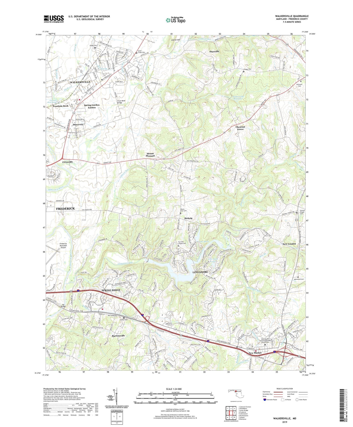
2019 topographic map quadrangle Walkersville in the state of Maryland. Scale: 1:24000. Based on the newly updated USGS 7.5' US Topo map series, this map is in the following counties: Frederick. The map contains contour data, water features, and other items you are used to seeing on USGS maps, but also has updated roads and other features. This is the next generation of topographic maps. Printed on high-quality waterproof paper with UV fade-resistant inks.
Quads adjacent to this one:
West: Frederick
Northwest: Catoctin Furnace
North: Woodsboro
Northeast: Union Bridge
East: Libertytown
Southeast: Damascus
South: Urbana
Southwest: Buckeystown
Contains the following named places: Addison Run, Alpine, Aspen, Auburn Farms, Aylor, Balmoral, Bartonsville, Bartonsville Census Designated Place, Bens Branch, Boyer Mill Heights, Cabbage Run, Calvary Assembly of God Church, Campers Hill, Central Chapel, Central Chapel Cemetery, Ceresville, Chapel Lutheran Church, Chapel Lutheran Church Cemetery, Cherry Run, Chestnut Grove, Coldstream, College Run, Collmus, Colony Village, Country Squire, Crum Road Bridge, Darby-Lux, Daysville, Daysville Acres, Deer Crossing Elementary, Deer Crossing Elementary School, Deerfield, Denneys Delight, Devil Branch, Discovery, Discovery Plaza Shopping Center, Discovery-Spring Garden Census Designated Place, District 13 Mount Pleasant, District 26 Walkersville, District 9 New Market, Double Tree Estates, Dublin Branch, Eaglehead Summerfield, East Branch, Elliot, Fairmont Cemetery, Fairview Chapel Cemetery, Fountain Rock, Fountain Rock Manor, Fountain Rock Spring, Fountain Rock Spring Park, Fox Pass, Frederick City Golf Course, Frederick County Evening High School, Frederick Filtration Plant, Glade Cemetery, Glade Elementary School, Glade Manor, Glade Town, Glade United Methodist Church, Grace Episcopal Church, Grace Trinity Reformed United Church of Christ, Green Village, Greenbrier, Hammond Cemetery, Harshman Estates, Hartman, Haul Road Dam, Hazelnut Run, Henleys, Hickory Hill, High Barbaree, Hines Woods, Holly Hills Country Club, Honey Hill, Hoot'N Hollow, Horse Shoe Farms Estates, Hughes Ford, Hunting Hills, Intercoastal Industrial Center, Islands of Balmoral, Israel Creek, Israel Creek Cemetery, Jug Bridge, Keyser, Lake Anita Louise, Lake Linganore, Lake Linganore Dam, Lake Marian, Lake Merle, Laurel Branch, Liberty Elementary School, Libertytown Shopping Center, Linganore Census Designated Place, Linganore Creek, Linganore Mill, Linganore-Bartonsville Census Designated Place, Long Branch, Longview, Martin, McKaig, Meadowlake Dam, Meadows, Mount Carmel Church, Mount Pleasant, Mount Pleasant East, Mount Pleasant Estates, Mount Pleasant Reformed Church, Mount Pleasant United Methodist Church, Mount Vernon United Brethren Church, Mount Zion Cemetery, Mount Zion Church, New London, New Market, New Market Community Park, New Market Elementary School, New Market Farms, New Market Historic District, New Market Middle School, New Market Post Office, New Market Shopping Center, New Market United Methodist Church, New Market United Methodist Church Cemetery, New Market Volunteer Fire Company Station 15, New Market West, Nightingale, North Shore, Oak Acres, Oakdale Elementary School, Oakdale Middle School, Olacin, Peace and Plenty, Pine Cliff, Pinehurst, Pleasant Estates, Pleasant Heights, Pleasant Oaks, Pleasant Ridge, Reichs Ford Estates, Remsburg Heights, Rhod-Ayr, Saint James African Methodist Episcopal Church, Saint Paul Lutheran Church, Saint Timothy Catholic Church, Sanandrews, Scouts Knoll, Silver Hill, Silver Hill Church, Simpson Methodist Episcopal Church, Sponsellers, Spring Garden Estates, Spring Ridge, Spring Ridge Census Designated Place, Spring Ridge Elementary School, Spring Ridge Fire Station 33, Stauffer, Ten Oaks, The Greens, Thompson Estates, Town Branch, Town of New Market, Town of Walkersville, Trinity Cemetery, Tuscarora Creek, Upper Pinehurst Dam, Vanishing Pond Farm, Venture and Luck Farms, View More Heights, Viewsite Estates, Walkers Village Shopping Center, Walkersville, Walkersville Branch Library, Walkersville Community Park, Walkersville Elementary School, Walkersville High School, Walkersville Library, Walkersville Middle School, Walkersville Post Office, Walkersville Reservoir, Walkersville Town Hall, Walkersville United Methodist Church, Walkersville Volunteer Fire Company Station 11, Walkersville Volunteer Rescue Company Station 24, Walnut Run, Wayman Church, Wayne, West Winds Country Club and Golf Course, Westwood, Whisperren Oaks, William Branch, Winter Springs, Wood Run, Woodridge, Woodspring, Woodsworth Estates, Yeager, ZIP Codes: 21701, 21774, 21793