MyTopo
Sterling Massachusetts US Topo Map
Couldn't load pickup availability
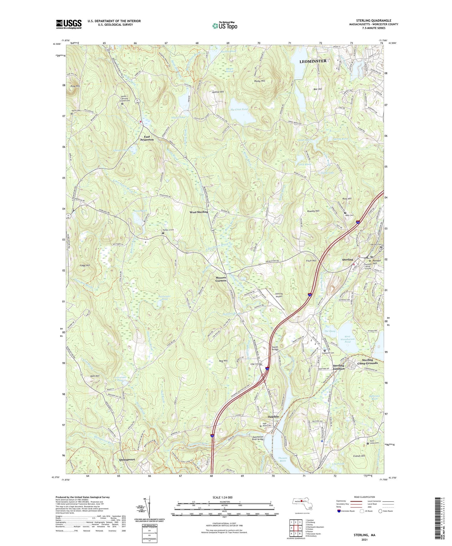
2021 topographic map quadrangle Sterling in the state of Massachusetts. Scale: 1:24000. Based on the newly updated USGS 7.5' US Topo map series, this map is in the following counties: Worcester. The map contains contour data, water features, and other items you are used to seeing on USGS maps, but also has updated roads and other features. This is the next generation of topographic maps. Printed on high-quality waterproof paper with UV fade-resistant inks.
Quads adjacent to this one:
West: Wachusett Mountain
Northwest: Gardner
North: Fitchburg
Northeast: Shirley
East: Clinton
Southeast: Shrewsbury
South: Worcester North
Southwest: Paxton
Contains the following named places: Babcock Brook, Bailey Brook, Ball Brook, Bartlett Pond, Bartlett Pond Brook, Bartlett Pond Dam, Bartlett Swamp, Bee Hill, Bethlehem Baptist Church, Butterick School, Chockset School, Chocksett Burial Ground, Clearview Farm, Cold Brook, Connelly Brook, Cookshire Cemetery, Cournoyer Pond, East Princeton, East Wachusett Brook, Fall Brook Elementary School Library, Fall Brook Reservoir, Fall Brook Reservoir Dam, Fall Brook School, First Church in Sterling, Fitch Basin, Fitch Basin Dam, Fitch Hill, Flagg Hill, French Hill, Glutner Pond, Governor Brook, Heywood Reservoir, Heywood Reservoir Dam, High Plain Cemetery, Hog Hill, Holt Hill, Houghton Brook, Hycrest Farm Pond Dam, Hy-Crest Pond, Justice Brook, Justice Hill, Kendall Hill, Keyes Brook, Lake Samoset, Lake Samoset Dam, Legg Cemetery, Legge Cemetery, Lily Ponds, Lynde Basins, Lynde Brook, Malden Brook, Maryellen Butterick School, Massachusetts Youth Institution, Mixter School, Moores Corners, Muddy Pond, Norco Sportsmens Club, Oak Hill Cemetery, Oakdale, Old Oak Apple Farm, Parker 2 Cemetery, Pine Hill, Poutwater Pond, Princeton Fire Department Station 2, Princeton School, Quabbin Aqueduct, Quinapoxet, Quinapoxet River, Quinepoxet River Bridge, Rock Church, Rocky Brook, Rocky Hill, Ross Hill, Rowley Hill, Saint Lukes Cemetery, Saint Richards Church, Samoset School, Scanlon Brook, Sholan Farms, Snow Pond, Snow Pond Dam, Spring Basin, Steam Mill Brook, Sterling, Sterling Airport, Sterling Camp Grounds, Sterling Center Historic District, Sterling Fire Department, Sterling Junction, Sterling Post Office, Sterling Town Hall, Stillwater Basin, Stillwater River, Stones Bridge, Stuart Pond, Stuart Pond Dam, The Quag, Thomas Basin, Thomas Prince Elementary School, Town of Sterling, Trout Brook, Tuttle Lake, Upper Lynde Basin Dam, Upper Lynde Basin Reservoir, Washburn Brook, Waushacum Brook, West Boylston Police Department, West Cemetery, West Sterling, West Waushacum Pond, Wilder Brook, ZIP Codes: 01522, 01564