MyTopo
Clinton Massachusetts US Topo Map
Couldn't load pickup availability
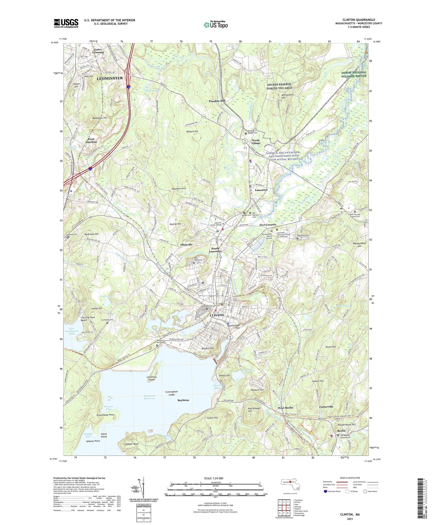
2024 topographic map quadrangle Clinton in the state of Massachusetts. Scale: 1:24000. Based on the newly updated USGS 7.5' US Topo map series, this map is in the following counties: Worcester. The map contains contour data, water features, and other items you are used to seeing on USGS maps, but also has updated roads and other features. This is the next generation of topographic maps. Printed on high-quality waterproof paper with UV fade-resistant inks.
Quads adjacent to this one:
West: Sterling
Northwest: Fitchburg
North: Shirley
Northeast: Ayer
East: Hudson
Southeast: Marlborough
South: Shrewsbury
Southwest: Worcester North
Contains the following named places: Abundant Life Fellowship, Apple Lane Orchard, Atlantic Union College, Ballard Hill, Ballville, Bartlett Pond, Berlin, Berlin Fire Department, Berlin Memorial School, Berlin Police Station, Berlin Town Hall, Bigelow Free Public Library, Bolton Flats Wildlife Management Area, Bolton Post Office, Bowers School, Boylston, Browning Elementary-South Lancaster Academy, Browning Memorial School, Burdett Hill, Carlisle Park, Carterville, Carville Basin, Cemetery Island, Central Park, Church of the God Shepherd, Clamshell Pond, Clinton, Clinton Area Chamber of Commerce, Clinton Census Designated Place, Clinton District Courthouse, Clinton Elementary School, Clinton Fire Station, Clinton Historical Society Building, Clinton Hospital, Clinton Junior-Senior High School, Clinton Middle School, Clinton Police Station, Clinton Post Office, Clinton Senior High School, Clinton Town Hall, Coachlace Pond, Coburn Hill, Congregation Shaarei Zedech, Convent of the Cenacle, Corcoran School, Cosgrove Aqueduct, Cunningham Ledge, Dame School, Deershorn Farm, Deershorns, Department of Corrections Pre-Release Center, Doctor Franklin Perkins School, Downtown Clinton Historic District, Duck Harbor, East Waushacum Pond, Eastwood Cemetery, Ebenville, Evangelical Congregational Church, Fairbanks Cemetery, Faith Bible Baptist Church, First Baptist Church of Clinton, First Church of Christ, First Church of Christ Scientist, First Parish Church of Berlin, Fiske Hill National Park, Fitch Pond, Five Corners, Forbes School, Four Ponds, Fuller Field, Fuller Pond, Fullerville, G Eric Jones Library, Gasna Gora School, Gates Crossing, George Hill, Goodridge Brook, Greenhalge Point, Greenly School, Hastings Cove, Hawthorn Hill, Hillside Cemetery, International Golf Club, Jasna Gora School, Kendall Cove, Lancaster, Lancaster Ambulance Service, Lancaster Fire Department Station 1 Headquarters, Lancaster Fire Department Station 2, Lancaster Historical Commission Library, Lancaster Memorial School, Lancaster Middle School, Lancaster Millpond, Lancaster Post Office, Lancaster State Forest, Lancaster Town Hall, Lancaster Town Police Department, Larkin Hill, Legate Hill, Living Stones Christian School, Major Walsh School, Mary Rowlandson Elementary School, Massachusetts State Industrial School for Girls, McGovern Brook, Meadowbrook Orchards, Middle Cemetery, Mossy Pond, Nashoba Regional High School, New England Montessori Children's House, New River Academy, Nicewicz Farm, North Nashua River, North Village, North Village Cemetery, Northbrook Greenhouses, Oak Hill Cemetery, Old Burying Ground Cemetery, Old Settlers Cemetery, Parkhurst School, Peach Hill, Perkins School, Pine Hill, Pinecrest Country Club, Ponakin Brook, Ponakin Mill, Powderhouse Hill, Pratt Junction, Pratts Pond, Presbyterian Church USA, Prescott Cove, Rattlesnake Hill, Redstone Hill, Reservoir Pines Cemetery, Reubens Hill, Ropers Brook, Runaway Brook Country Club, Saint Johns Cemetery, Saint Johns Church, Saint Johns School, Saint Joseph Church, Saint Nicholas Greek Orthodox Church, Sandy Pond, Sawyer Bluff, Schartner Farm, Seventh Day Adventist Village, Sholan Park, South Lancaster, South Lancaster Academy, South Lancaster Census Designated Place, South Lancaster Post Office, South Meadow Brook, South Meadow Pond, Spectacle Brook, Sterling Police Department, Sterling Town Beach, Still River, Sunny Crest Orchards, Sweat Hill, Tahanto Point, Terrace Shopping Center, Tolman Greenhouse, Town of Berlin, Town of Clinton, Town of Lancaster, Trinity Church, United Church, Wachusett Dam, Wachusett Reservoir, Wataquadock Hill, WBSO-AM (Clinton), Wekepeke Hill, Welch Pond, West Berlin, West Burying Ground Cemetery, Whittemore Hill, Wilson Hill, Wood Island, Woodlawn Cemetery, Woodruff Plaza, Worcester County Hospital, ZIP Codes: 01503, 01510, 01523, 01561