MyTopo
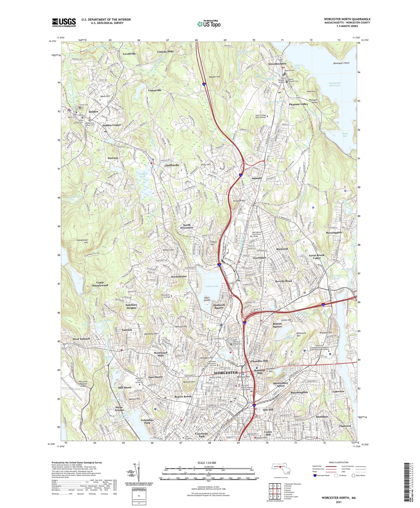
Worcester North Massachusetts US Topo Map
Couldn't load pickup availability
2024 topographic map quadrangle Worcester North in the state of Massachusetts. Scale: 1:24000. Based on the newly updated USGS 7.5' US Topo map series, this map is in the following counties: Worcester. The map contains contour data, water features, and other items you are used to seeing on USGS maps, but also has updated roads and other features. This is the next generation of topographic maps. Printed on high-quality waterproof paper with UV fade-resistant inks.
Quads adjacent to this one:
West: Paxton
Northwest: Wachusett Mountain
North: Sterling
Northeast: Clinton
East: Shrewsbury
Southeast: Grafton
South: Worcester South
Southwest: Leicester
This map covers the same area as the classic USGS quad with code k42071c7.
Contains the following named places: Andover Street School, Asnebumskit Brook, Atlantic Trade Heliport, Babcock Block, Barbers Crossing, Barbers Crossing Station, Barbers Station, Beaman Cemetery, Beaver Brook, Beaver Brook Park, Beaver Street Historic District, Bell Pond, Bell Pond Dam, Belmont Hill, Belmont Hospital, Beverly Road, Bloomingdale, Brittan Square, Bryant Pond, Burncoat, Burncoat Park, Burncoat Street Playground, Camp Kinneywood, Canada Mills, Carrolls Pond, Cascade Park, Castle Street Row, Chadwick Square, Chaffin Pond, Chaffin Pond Dam, Chaffins Brook, Chaffinville, Chandler Hill, Chandler Hill Park, City Farm Pond, City of Worcester, Coal Mine Brook, Coes Pond, Coes Reservoir, Coes Reservoir Dam, Columbus Park, Cook Pond, Cook Pond Dam, Country Club Plaza Shopping Center, Crompton Park, Dana Avenue Playground, Davenport Point, Davis Hill, Davis Tower, Dawson, Dawson Pond, Digital - Headmaster Heliport, Digital - Training Heliport, Doctors Hospital, Dodge Park, Dover Point, Drury Hill, Edwards Pond, Elm Park, Elm Street Historic District, Fairlawn Rehabilitation Hospital, Fay Street Historic District, Franklin Square, Galleria at Worcester Center, Galleria at Worcester Center Shopping Center, Gates Brook, Gates Cove, General Foley Stadium, Goddard Industrial Park, Goodale Park, Great Brook Valley, Greater Brook Valley Playground, Green Hill, Green Hill Golf Course, Green Hill Park, Green Hill Pond, Green Hill Pond Dam, Greendale, Greendale Station, Grove Cemetery, Hahnemann Hospital, Hamilton, Hammond Heights, Hancock Hill, Hermitage Pond, Higgins Industrial Park, Holden, Holden Center, Holden Center Historic District, Holden District Hospital, Holden Reservoir Number One Dam, Holden Reservoir Number Two, Holden Reservoir Number Two Dam, Holden Shopping Center, Houghton Street Historic District, Indian Hill, Indian Lake, Indian Lake Dam, Ingleside Avenue Historic District, Institute Park, Institutional District, Junction Shop and Herman Street Historic District, June Street, Kendrick Field, Lake Park, Lake Quinsigamond, Lakeview, Lamson Brook, Lee Street School, Lincoln Estate-Elm Park Historic District, Lincoln Plaza, Lincoln Plaza Shopping Center, Lincoln Square, Logan Field, Lovellville, Lower Pleasant Street District, Lynde Brook Reservoir Dam, Lynde Brook Reservoir Dike, Malden Hill, Marshall Pond, Marshall's Airport, Massachusetts Avenue Historic District, Massachusetts Biotech Research Park, May Street Historic District, Meadowbrook Shopping Center, Mechanics Hall District, Mid Town Mall, Mill Street, Millstone Hill, Moreland Hill, Morgan Park, Morningdale, Mount Vernon Cemetery, Mud Pond, Muddy Brook, Newton Hill, Norcross Pond Number Three, North High School, North Worcester, Northville, Norwich Place Shopping Center, Oak Hill, Old Burying Ground, Old Burying Ground Cemetery, Oread Castle Park, Oxford-Crown Historic District, Park Avenue Cemetery, Parker Aviation Heliport, Parker Heliport, Patch Pond, Patch Reservoir, Patch Reservoir Dam, Perkins Industrial Park, Pine Hill, Pinecrest, Pleasant Valley, Poor Farm Brook, Pout Pond, Prospect Hill, Providence Street Historic District, Quinsicamond State Park, Ramshorn Island Park, Regatta Point Park, Rockwood Field, Rural Cemetery and Crematory, Saint Mary's Cemetery, Salisbury Heights, Salisbury Park, Salisbury Pond, Salisbury Pond Dam, Scarletts Brook, Sears Island, Sewall Brook, Sholan Point, Shrewsbury Street, Smith Pond, South Bay, Stonehouse Hill, Stratton Hill, Summit, Summit Station, Swan Avenue, Tatnuck, Tatnuck Country Club, Tatnuck Hill, The Cascade, The Oval, Town of Holden, Town of West Boylston, Union Hill, Unionville, Unionville Pond, University of Massachusetts Medical Center - Memorial Campus, University of Massachusetts Medical Center Heliport, University of Massachusetts Memorial Medical Center University Campus, University Park, Wachusett Country Club, Wachusett Plaza Shopping Center, Walnut Hill, Warren Tannery Brook, WCUW-FM (Worcester), Weasel Brook, West Boylston, West Boylston Brook, West Brook, West Tatnuck, Westchester, Westwood Hills, WFTQ-AM (Worcester), White City East Shopping Center, WICN-FM (Worcester), Wigwam Hill, Williams Millpond, Winter Hill, WNEB-AM (Worcester), Worcester, Worcester Center, Worcester Center Galleria, Worcester City Hospital, Worcester Common, Worcester Country Club, Worcester County Hospital, Worcester Polytechnic Institute, Worcester Recovery Center and Hospital, Worcester Regional Airport, Worcester Station, WTAG-AM (Worcester), ZIP Codes: 01520, 01583, 01602, 01604, 01605, 01606, 01608, 01609