MyTopo
Wachusett Mountain Massachusetts US Topo Map
Couldn't load pickup availability
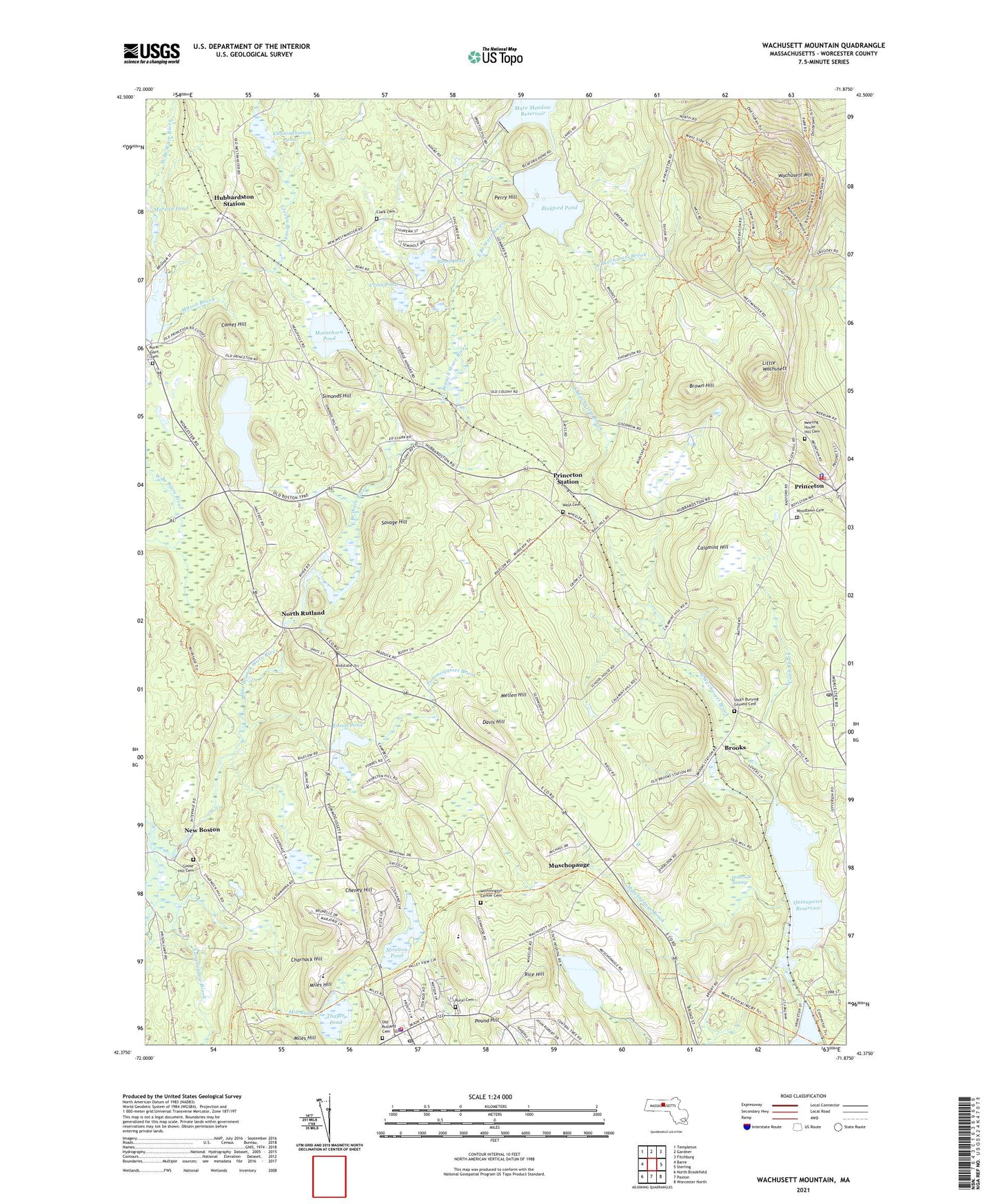
2021 topographic map quadrangle Wachusett Mountain in the state of Massachusetts. Scale: 1:24000. Based on the newly updated USGS 7.5' US Topo map series, this map is in the following counties: Worcester. The map contains contour data, water features, and other items you are used to seeing on USGS maps, but also has updated roads and other features. This is the next generation of topographic maps. Printed on high-quality waterproof paper with UV fade-resistant inks.
Quads adjacent to this one:
West: Barre
Northwest: Templeton
North: Gardner
Northeast: Fitchburg
East: Sterling
Southeast: Worcester North
South: Paxton
Southwest: North Brookfield
Contains the following named places: Asnacomet Pond, Asnacomet Pond Dam, Bems Pond, Bems Pond Dam, Bickford Pond, Bickford Pond Dam, Bickford Reservoir Dam, Brigham Pond, Brigham Pond Dam, Brooks, Brown Hill, Calamint Hill, Central New England Sanatorium, Charnock Hill, Cheney Hill, Clark Cemetery, Cobb Brook, Comet Hill, Cross Pond, Cross Pond Dam, Cunningham Pond, Davis Hill, Echo Lake, Edson Pond, First Congregational Church, Goose Hill Cemetery, Holbrook Swamp, Hubbardston Station, Hubbardston Wildlife Management Area, Joslin Brook, Ketonen - Clark Farm, Little Wachusett, Longmeadow Brook, Maple Spring Pond, Maple Spring Pond Dam, Marcan Pond, Mare Meadow Reservoir Dam, Mason Brook, Mellen Hill, Miles Hill, Mill Brook, Minns Wildlife Sanctuary, Moosehorn Pond, Moulton Pond, Muschopauge, Muschopauge Brook, Muschopauge Pond, Muschopauge Pond Dam, New Boston, North Rutland, North Woods, Perry Hill, Pommoqusset Brook, Pound Hill, Prince of Peace Parish Church, Princeton, Princeton Fire Department, Princeton First Congregational Church, Princeton Police Department, Princeton Post Office, Princeton Public Library, Princeton Station, Princetonw Town Hall, Quinapoxet Reservoir, Rice Hill, Rural Glen Cemetery, Ruralville, Rutland Fire Department, Rutland Free Public Library, Rutland Heights Hospital, Rutland Police Department, Rutland Post Office, Saint Patricks Church, Savage Hill, Simonds Hill, South Burying Ground Cemetery, South Wachusett Brook, Thayer Pond, Thomas Prince School, Town of Princeton, Town of Rutland, Wachusett Meadow Wildlife Sanctuary, Wachusett Mountain, Wachusett Mountain Ski Area, Wachusett Mountain State Reservation, West Cemetery, West Wachusett Brook, Woodlawn Cemetery, Worthington Center Cemetery, ZIP Codes: 01541, 01543