MyTopo
Allegan Michigan US Topo Map
Couldn't load pickup availability
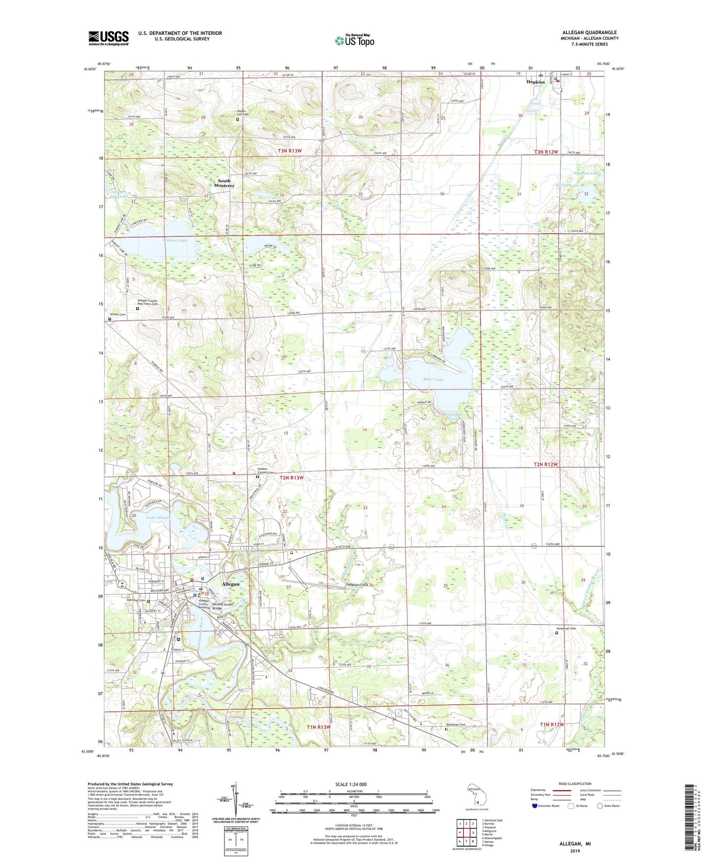
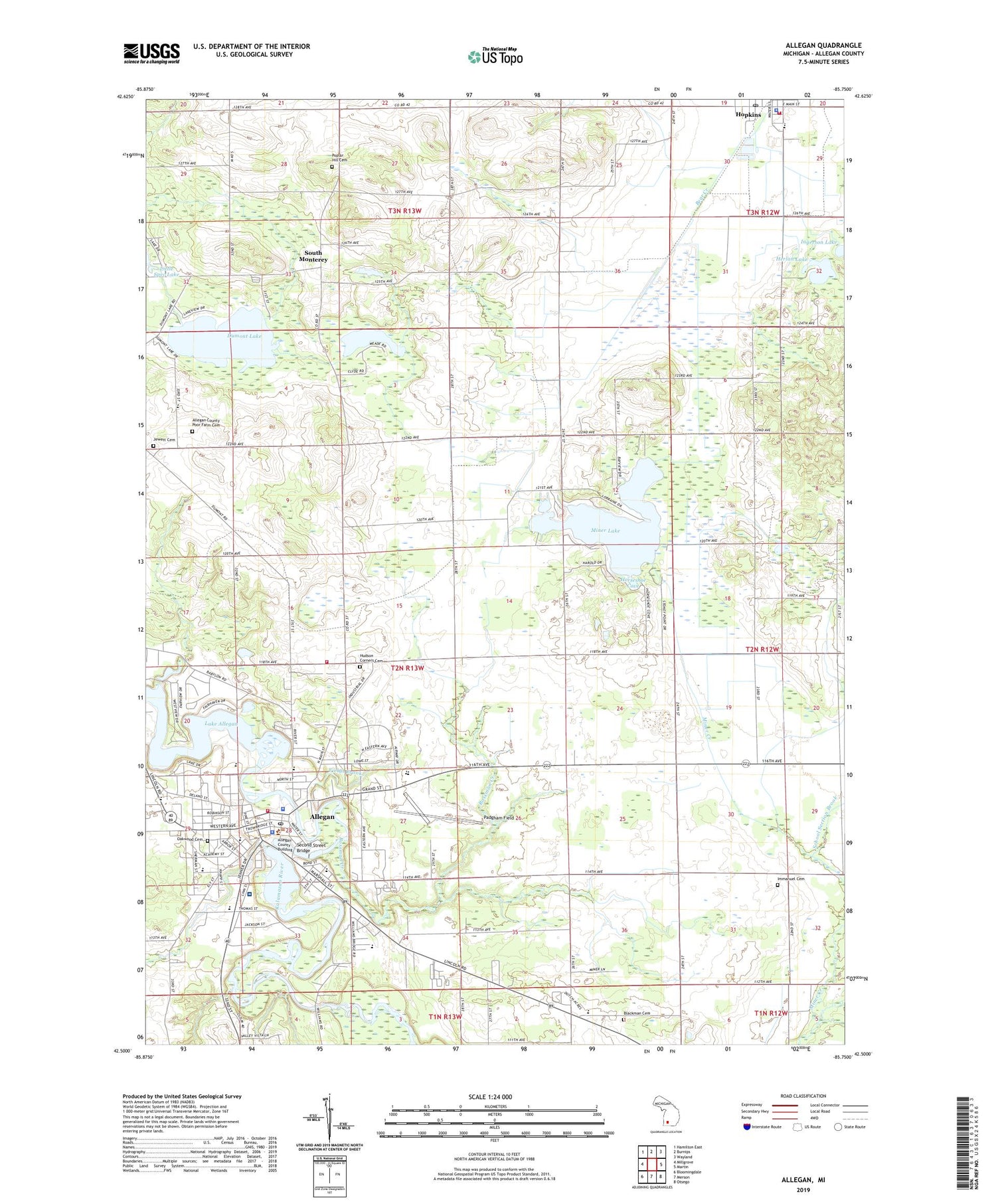
2019 topographic map quadrangle Allegan in the state of Michigan. Scale: 1:24000. Based on the newly updated USGS 7.5' US Topo map series, this map is in the following counties: Allegan. The map contains contour data, water features, and other items you are used to seeing on USGS maps, but also has updated roads and other features. This is the next generation of topographic maps. Printed on high-quality waterproof paper with UV fade-resistant inks.
Quads adjacent to this one:
West: Millgrove
Northwest: Hamilton East
North: Burnips
Northeast: Wayland
East: Martin
Southeast: Otsego
South: Merson
Southwest: Bloomingdale
Contains the following named places: Abronia Post Office, Abronia Station, Allegan, Allegan Bible Church, Allegan Christian Reformed Church, Allegan City Hall, Allegan County Courthouse, Allegan County Fairgrounds, Allegan County Historical Marker, Allegan County Poor Farm Cemetery, Allegan County Sheriff's Office, Allegan Fire District, Allegan Fire District Station 2, Allegan High School, Allegan Library, Allegan Medical Clinic, Allegan Mobile Estates, Allegan Police Department, Allegan Post Office, Allegan Station, Ascension Borgess Allegan Hospital, Assembly of God Church, Blackman Cemetery, Blackman School, Blessed Sacrament Catholic Church, Camp Beechpoint, Church of Jesus Christ of Latter Day Saints, City of Allegan, Dawson Elementary School, Dendel Orchards, Dumont Lake, Dumont Lake Campground, Dumont Lake County Park, Episcopal Church of the Good Shepherd, Episcopal Church of the Good Shepherd Historical Marker, Faith Baptist Church, Fields Brook, First Baptist Church of Allegan, First Church of God, First Congregational Church, First Presbyterian Church, Grace Community Church, Griswold Memorial Auditorium, Herlan Lake, Hopkins, Hopkins Area Fire Department / Rescue, Hopkins Community Reformed Church, Hopkins Elementary School, Hopkins High School, Hopkins Police Department, Hopkins Post Office, Hopkins Public Library, Hopkins Station, Horseshoe Cove, Hudson Corners Cemetery, Hudson Corners School, Immanuel Cemetery, Immanuel Church, Immanuel Lutheran Church, JayCee Park, Jewett Cemetery, Jewett School, Kellogg Post Office, Kellogg Station, Kingdom Hall, Life Emergency Medical Services Ambulance Allegan, Mahan Park, Mapleview School, Miner Creek, Miner Lake, Miner Lake School, Minerlake Post Office, North Ward School, Oakwood Cemetery, Old Jail Museum, Padgham Field, Pine Trails Elementary School, Poplar Hill Cemetery, Reorganized Church of Latter Day Saints, Riverfront Park, Rossman Creek, Rossman Esplanade Park, Saint John's Evangelical Lutheran Church, School Section Brook, Second Street Bridge, Second Street Bridge Historical Marker, Seventh-Day Adventist Church, South Monterey, South Monterey Church, South Monterey Post Office, Sue Lange Memorial Park, Township of Allegan, United Methodist Church, Wesleyan Church, West Ward Elementary School, Wetmore Lake, Wetmore School, White Junior High School, WKGH-FM (Allegan), WQXC-FM (Otsego), Wright School, ZIP Code: 49010