MyTopo
Belle Isle Michigan US Topo Map
Couldn't load pickup availability
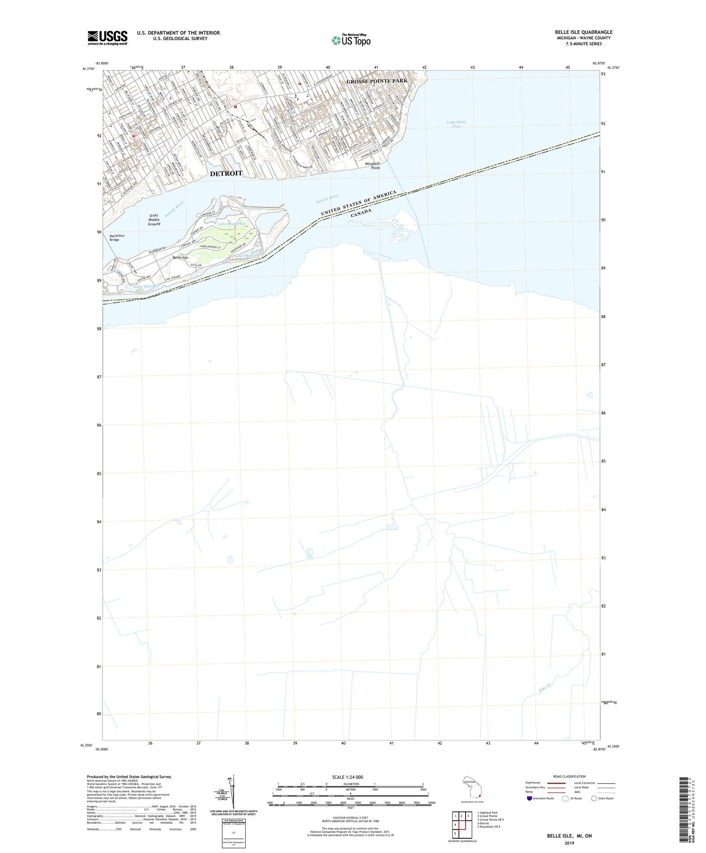
2023 topographic map quadrangle Belle Isle in the state of Michigan. Scale: 1:24000. Based on the newly updated USGS 7.5' US Topo map series, this map is in the following counties: Wayne. The map contains contour data, water features, and other items you are used to seeing on USGS maps, but also has updated roads and other features. This is the next generation of topographic maps. Printed on high-quality waterproof paper with UV fade-resistant inks.
Quads adjacent to this one:
West: Detroit
Northwest: Highland Park
North: Grosse Pointe
Northeast: Grosse Pointe OE E
Southwest: Wyandotte OE E
This map covers the same area as the classic USGS quad with code o42082c8.
Contains the following named places: Alfred Brush Ford Park, Annunciation School, Belle Isle, Belle Isle Aquarium, Belle Isle Golf Course, Belle Isle Historical Marker, Belle Isle Park, Blue Heron Lagoon, Boysville's of Michigan -Saint Rose, Brodhead Naval Armory Historical Marker, Brow Marina, Celestial Tabernacle Baptist Church, Chandler Park Academy-Philip, Christian Liberty Baptist Church, Church of Latter Day Saints Temple, City of Detroit Fire Department Emergency Medical Services Medic 12, City of Detroit Fire Department Engine 26 Ladder 14, City of Detroit Fire Department Engine 32, City of Detroit Fire Department Engine 38 Ladder 29, City of Detroit Launching Ramps, City of Grosse Pointe Park, Conners Creek, Conventional Baptist Church, Crib Light, Detroit Boat Club, Detroit Enterprise Academy, Detroit Yacht Club, Doctor Ossian Sweet Home Historical Marker, Dossin Great Lakes Museum, East Side Central Church of Christ, Eastside Bus Terminal, Engel Memorial Park, Ephiphany Lutheran Church, Erma Henderson Marina, Fishermans Marina, Fleming Channel, Foch School, Ford Park, Fox Creek, Fox Creek Post Office, Fox Indian Massacre Historical Marker, Gallagher Playground, Golightly Career and Technical Center, Golightly Career and Technical for Center, Guyton School, Hansen Playground, Harbor Hill Marina, Historic East Lake Baptist Church, Howe School, Indian Village Historical Marker, Iroquois Avenue Christ Lutheran Church, Iskcon School, Jefferson Avenue Church, Jefferson Avenue Presbyterian Church, Jefferson Avenue Presbyterian Church Historical Marker, Jefferson Post Office, Johnson H McKinney Day Treatment Center, Julia Ward Howe Elementary School, Keans Detroit Yacht Harbor, Keating School, Lake Muskoday, Lake Okonoka, Lake Tacoma, Lillibridge School, Lingemann School, MacArthur Bridge, Maharas Gentry School, Maheras Memorial Playground, Memorial Park Marina, Mercy Family Care, Monteith School, Mount Olive East Baptist Church, New Christian Missionary Baptist Church, New Mount Vernon Baptist Church, Nichols School, Original Primitive Baptist Church, Ossian Sweet Home Historical Marker, Owen Park, Peche Island Light, Pingree School, Police Dispatch Radio Historical Marker, Precinct 5 Police Station, Pure in Heart Baptist Church, Ransom Eli Olds Historical Marker, Reid Memorial Park, Remus Robinson Middle School, Revelation and Truth Missionary Baptist Church, Rising Saints in God Church, Riverbend Plaza Shopping Center, Rosstertial Marina, Safe Hope Church of God in Christ, Saint Clair Heights Post Office, Saint John Detroit Riverview Hospital, Saint Maron Cathedral, Saint Martin School, Samaritan Missionary Baptist Church, Scott Middle Ground, Scripps Annex School, Scripps School, Solid Rock Church of God in Christ, Southeastern High School, Stark School of Technology, Tendler School, Tennessee Missionary Baptist Church, Threemile Drive Park, Trombly Alternative High School, Trombly School, Waterworks Park, William Livingstone Memorial Light, Willis Temple Church of God in Christ, Windmill Point, Windmill Point Light, Windmill Point Lighthouse, Zion Progress Baptist Church, ZIP Code: 48214